File:Map of 1st. distrt. Campbell Co. Georgia - south of the Cherokee boundy. line LOC 2012655032.jpg
Jump to navigation
Jump to search

Size of this preview: 659 × 600 pixels. Other resolutions: 264 × 240 pixels | 528 × 480 pixels | 844 × 768 pixels | 1,126 × 1,024 pixels | 2,251 × 2,048 pixels | 6,594 × 5,999 pixels.
Original file (6,594 × 5,999 pixels, file size: 6.72 MB, MIME type: image/jpeg)
Captions
Captions
Add a one-line explanation of what this file represents
Summary
[edit]| Description |
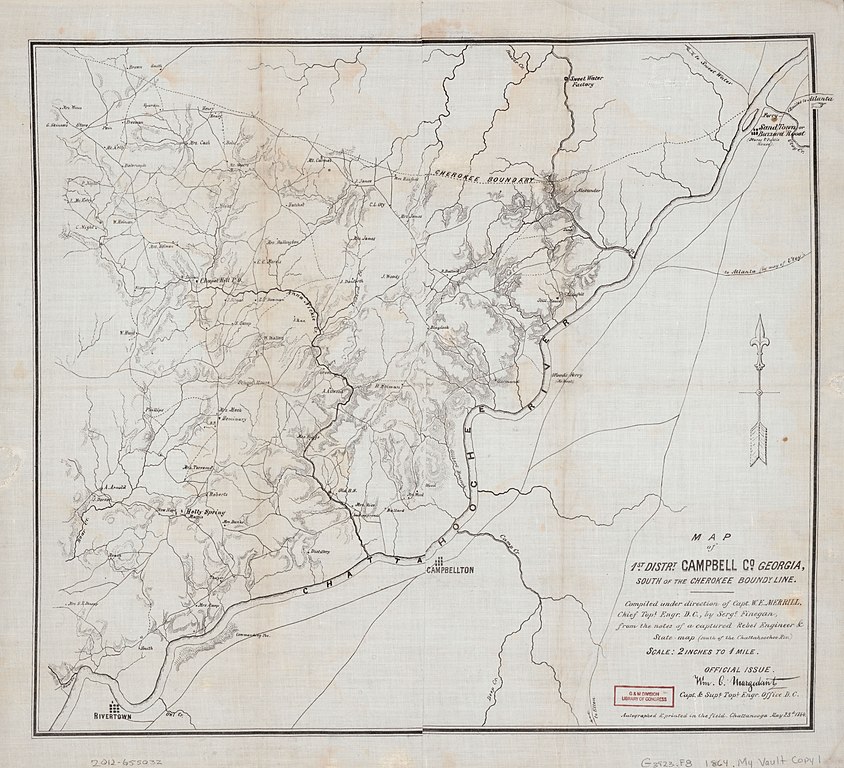
English: Shows local topography, roads, and names of some residents. Relief shown by hachures. " ... from the notes of a captured Rebel Engineer & State map (south of the Chattahoochee Riv.)." "Autographed & printed in the field. Chattanooga May 23d. 1864." "Official issue. Wm. C. Margedant, Capt. & Supt. Topl. Engr. Office D.C." Cloth map. Campbell County, Georgia was a county from 1828 to 1931. Divided at the Chattahoochee River the northwestern half of Campbell County became Douglas County in 1870 and the remainder was ceded to Fulton County at the end of 1931. LC copy imperfect: Discoloration along fold lines. Available also through the Library of Congress Web site as a raster image. |
||
| Title | Map of 1st. distrt. Campbell Co. Georgia : south of the Cherokee boundy. line | ||
| Shelf ID | G3923.F8 1864 .M4 | ||
| Date | |||
| Source | https://www.loc.gov/item/2012655032/ | ||
| Author | Merrill, W. E. (William Emery); Margedant, Wm. C. (William C.) | ||
| Permission (Reusing this file) |
|
||
| Other versions |
|
||
| Location | United States · Campbell County · Fulton County · Georgia | ||
| Part of | Military Battles And Campaigns · American Memory · Civil War Maps · Catalog · Geography And Map Division | ||
| Subject | Georgia · Campbell County · Civil War · United States · Maps · Fulton County · Fulton County (Ga.) · Campbell County (Ga.) · Landowners |


Licensing
[edit]
|
This is a faithful photographic reproduction of a two-dimensional, public domain work of art. The work of art itself is in the public domain for the following reason:
The official position taken by the Wikimedia Foundation is that "faithful reproductions of two-dimensional public domain works of art are public domain".
This photographic reproduction is therefore also considered to be in the public domain in the United States. In other jurisdictions, re-use of this content may be restricted; see Reuse of PD-Art photographs for details. | ||||
File history
Click on a date/time to view the file as it appeared at that time.
| Date/Time | Thumbnail | Dimensions | User | Comment | |
|---|---|---|---|---|---|
| current | 01:01, 10 May 2018 | | 6,594 × 5,999 (6.72 MB) | Fæ (talk | contribs) | LOC Maps https://www.loc.gov/item/2012655032/ #5118 |
You cannot overwrite this file.
File usage on Commons
The following page uses this file: