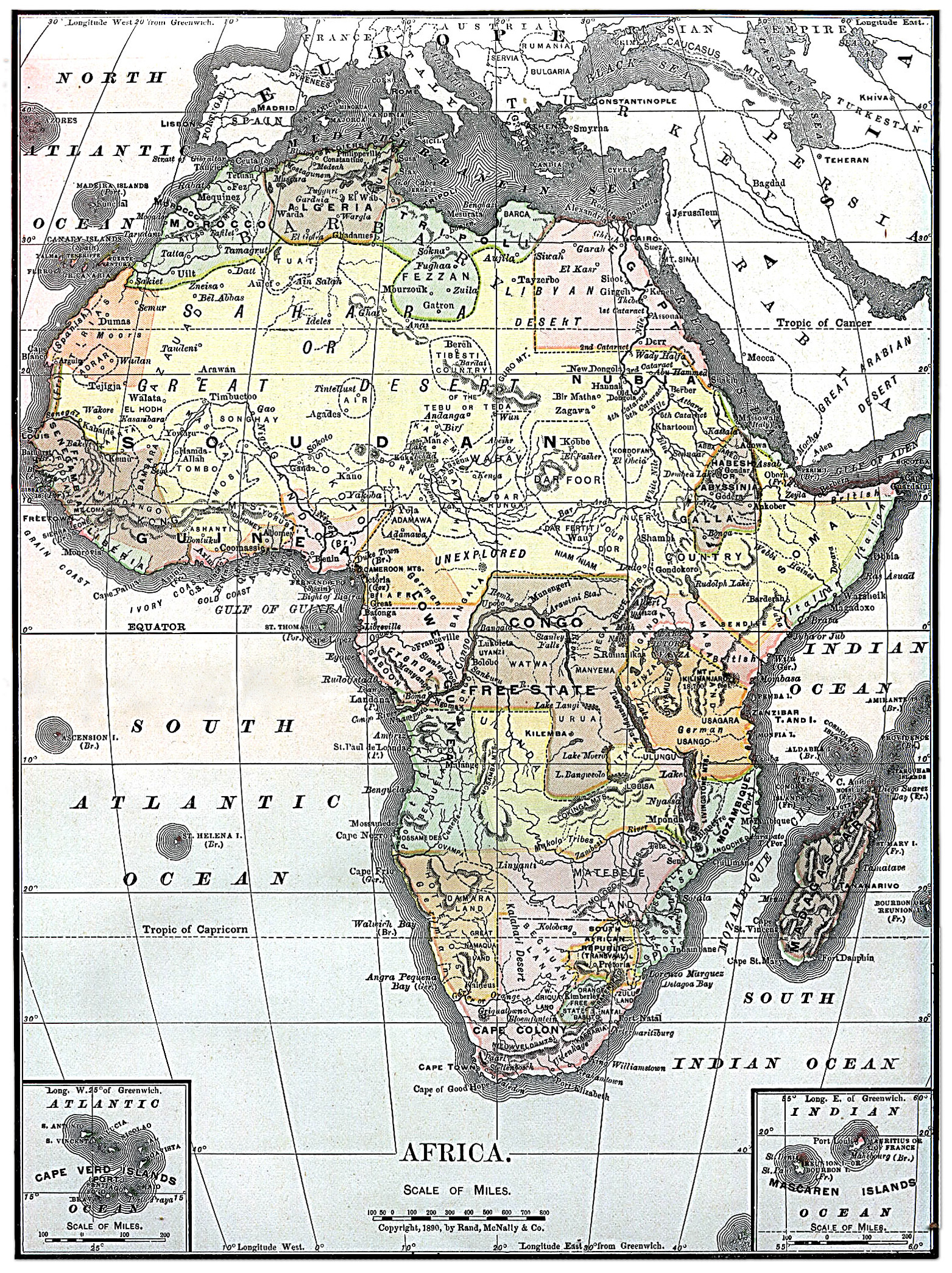
File:Map of Africa from Encyclopaedia Britannica 1890.jpg
Rozmiar pierwotny (1563 × 2090 pikseli, rozmiar pliku: 2,07 MB, typ MIME: image/jpeg)
Podpisy
Podpisy
Opis[edytuj]
Licencja[edytuj]
|
Ten materiał przeszedł do domeny publicznej w kraju pochodzenia, jak również w państwach i terytoriach, gdzie prawo autorskie wygasa w ciągu 70 lat po śmierci autora.
| |
| Plik rozpoznano jako wolny od znanych ograniczeń praw autorskich, włącznie z prawami zależnymi i pokrewnymi. | |
| This image comes from the 13th edition of the Encyclopædia Britannica or earlier. The copyrights for that book have expired in the United States because the book was first published in the US with the publication occurring before January 1, 1929. As such, this image is in the public domain in the United States. |  |
Ta grafika została wybrana grafiką dnia 24 czerwca 2005 roku. Została opisana następująco: Inne języki:
閩南語 / Bân-lâm-gú: 1890 nî Hui-chiu ê tē-tô·. Brezhoneg : Kartenn eus Afrika er bloaz 1890 Čeština: Mapa Afriky z roku 1890 Cymraeg: Map o Affrica yn y flwyddyn 1890 Dansk: Kort over Africa fra 1890 Deutsch: Karte von Afrika aus dem Jahr 1890 English: Map of Africa 1890 Español: Mapa de África del año 1890 Français : Carte du continent africain des années 1890. Galego: Mapa de África do ano 1890 Latina: Tabula geographica Africae, 1890 Nederlands: Kaart van Afrika uit 1890 Norsk nynorsk: Kart over Afrika frå 1890 Português: Mapa de África 1890 Slovenščina: Zemljevid Afrike, 1890. Suomi: Vuoden 1890 Encyclopaedia Britannican Afrikan kartta Svenska: En karta över Afrika från 1890. Русский: Карта Африки 1890-ого года ગુજરાતી : આફ્રિકાનો નક્શો, ૧૮૯૦ ไทย: แผนที่ทวีปแอฟริกา ค.ศ. ๑๘๙๐ 日本語: アフリカの地図 (1890年) 中文: 非洲1890年地图 中文(繁體): 非洲1890年地圖 粵語: 1890 年嘅非洲地圖 עברית : מפה של אפריקה מ1890 |
Historia pliku
Kliknij na odpowiedniej dacie/czasie, aby zobaczyć wersję pliku z tamtego okresu.
| Data/czas | Miniatura | Wymiary | Użytkownik | Opis | |
|---|---|---|---|---|---|
| aktualny | 18:30, 4 sie 2010 | | 1563 × 2090 (2,07 MB) | Orionist (dyskusja | edycje) | fixed warp on the top and removed the seam in the middle |
| 18:15, 4 sie 2010 |  | 1563 × 2090 (1,57 MB) | Orionist (dyskusja | edycje) | higher resolution version | |
| 06:48, 4 sie 2010 |  | 787 × 1054 (425 KB) | PawełMM (dyskusja | edycje) | warp on top fixed | |
| 12:03, 5 gru 2004 |  | 787 × 1054 (410 KB) | TOR (dyskusja | edycje) | Map of Africa from Encyclopaedia Britannica, 1890 {{PD}} |
Nie możesz nadpisać tego pliku.
Lokalne wykorzystanie pliku
Następujące strony korzystają z tego pliku:
- Africa
- Atlas of Africa
- Maps of Africa
- Old maps
- User:Orionist
- User:Orionist/Gallery
- Commons:Potd/2005-06 (fr)
- Commons:Potd/2005-06 (pl)
- Commons:Potd/2005-06 (pt)
- Commons:Potd/2005-06 (tr)
- File:Afryka 1890.jpg (przekierowanie do pliku)
- Template:Potd/2005-06
- Template:Potd/2005-06-24
- Template:Potd/2005-06-24 (br)
- Template:Potd/2005-06-24 (cs)
- Template:Potd/2005-06-24 (cy)
- Template:Potd/2005-06-24 (da)
- Template:Potd/2005-06-24 (de)
- Template:Potd/2005-06-24 (en)
- Template:Potd/2005-06-24 (es)
- Template:Potd/2005-06-24 (fi)
- Template:Potd/2005-06-24 (fr)
- Template:Potd/2005-06-24 (gl)
- Template:Potd/2005-06-24 (gu)
- Template:Potd/2005-06-24 (he)
- Template:Potd/2005-06-24 (ja)
- Template:Potd/2005-06-24 (la)
- Template:Potd/2005-06-24 (nan)
- Template:Potd/2005-06-24 (nl)
- Template:Potd/2005-06-24 (nn)
- Template:Potd/2005-06-24 (pl)
- Template:Potd/2005-06-24 (pt)
- Template:Potd/2005-06-24 (ru)
- Template:Potd/2005-06-24 (sl)
- Template:Potd/2005-06-24 (sv)
- Template:Potd/2005-06-24 (th)
- Template:Potd/2005-06-24 (yue)
- Template:Potd/2005-06-24 (zh-hans)
- Template:Potd/2005-06-24 (zh-hant)
Globalne wykorzystanie pliku
Ten plik jest wykorzystywany także w innych projektach wiki:
- Wykorzystanie na arz.wikipedia.org
- Wykorzystanie na azb.wikipedia.org
- Wykorzystanie na bg.wiktionary.org
- Wykorzystanie na da.wikipedia.org
- Wykorzystanie na en.wikipedia.org
- User:Kentfowl
- User:Enlil Ninlil
- User:Hibernian
- User:Pwjb
- User:Cold Water
- User:ForestAngel
- User:Mr A
- User:Orionist
- User:Reno vercetti
- User talk:Gidonb/Archive 2008
- User:PinkPanthress
- User:El monty
- Wikipedia talk:WikiProject History/Task force images
- User:Patricius Augustus
- User:1c33y37
- User:Bubbles02
- User:HalleluYHWH
- User:HalleluYHWH/Userboxes/Africa
- User:Secret Saturdays
- User:Alumnum
- User:Yertul
- User:Sparrowhawk64
- User:Saukkomies/My userboxes
- User:Sewati
- User:HypertimeTraveller
- User:SocialPhysics
- Wikipedia:Graphics Lab/Photography workshop/Archive/Aug 2010
- User:Orionist/Gallery
- User:Metallurgist/userboxes
- User:Pacificus Viridis
- User:Mikisrb
- User:BrunGunth
- User:FeleciaQ
- User:Smart30
- User:Lyaika
- User:Flinders Petrie
- User:Bouncingnewsgreen
- User:Polskivinnik
- User:Ilmurov
- User:Autioitua
- User:IjonTichyIjonTichy
- User:Yo222
- User:Terminator484/sandbox
- User:Oxyaena
- User:Bodney/sandbox
- User:GangGangQuokka2
Pokaż listę globalnego wykorzystania tego pliku.