File:Map of Distant Early Warning (DEW) Line.jpg
Jump to navigation
Jump to search

Size of this preview: 800 × 531 pixels. Other resolutions: 320 × 213 pixels | 640 × 425 pixels | 1,024 × 680 pixels | 1,280 × 850 pixels | 3,000 × 1,993 pixels.
Original file (3,000 × 1,993 pixels, file size: 3.38 MB, MIME type: image/jpeg)
Captions
Captions
Add a one-line explanation of what this file represents
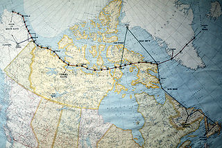
| Description | A map of North America near the Arctic Circle showing 30 radar sites spread out along the Distant Early Warning (DEW) Line. Running from Alaska, across Northern Canada to Greenland, the line is approximately 3,600 miles long. | |||
| Date | Taken on 20 February 1987 | |||
| Source | ID:DFST8803442 | |||
| Author |
Service Depicted: Air Force Command Shown: F3203 Camera Operator: TECH. SGT. DONALD L. WETTERMAN |
|||
| Permission (Reusing this file) |
|

File history
Click on a date/time to view the file as it appeared at that time.
| Date/Time | Thumbnail | Dimensions | User | Comment | |
|---|---|---|---|---|---|
| current | 00:06, 1 December 2006 | | 3,000 × 1,993 (3.38 MB) | Dual Freq (talk | contribs) | {{Information |Source=[http://www.dodmedia.osd.mil/Assets/1988/Air_Force/DF-ST-88-03442.JPEG ID:DFST8803442] |Author=Service Depicted: Air Force</br>Command Shown: F3203</br>Camera Operator: TECH. SGT. DONALD L. WETTERMAN |Description=A map of North Amer |
You cannot overwrite this file.
File usage on Commons
The following 2 pages use this file:
File usage on other wikis
The following other wikis use this file:
- Usage on da.wikipedia.org
- Usage on de.wikipedia.org
- Usage on en.wikipedia.org
- Usage on fr.wikipedia.org
- Usage on it.wikipedia.org
- Usage on ja.wikipedia.org
- Usage on no.wikipedia.org
- Usage on pl.wikipedia.org
- Usage on www.wikidata.org
_Line.jpg&oldid=708812491)