File:Map of Ethnic Groups (in Districts) in Afghanistan.jpg
Jump to navigation
Jump to search

Size of this preview: 792 × 599 pixels. Other resolutions: 317 × 240 pixels | 634 × 480 pixels | 1,015 × 768 pixels | 1,160 × 878 pixels.
Original file (1,160 × 878 pixels, file size: 303 KB, MIME type: image/jpeg)
Captions
Captions
Add a one-line explanation of what this file represents

_in_Afghanistan.jpg&action=edit&redlink=1)

|
File:Map of Ethnic Groups in Afghanistan, by district.svg is a vector version of this file. It should be used in place of this JPG file when not inferior.
File:Map of Ethnic Groups (in Districts) in Afghanistan.jpg → File:Map of Ethnic Groups in Afghanistan, by district.svg
For more information, see Help:SVG. |
 |
Summary[edit]
_in_Afghanistan.jpg&action=edit§ion=1)
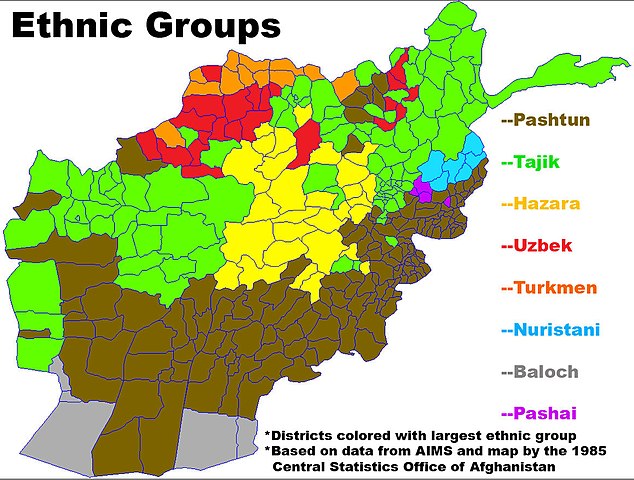
- Map showing the largest ethnic group in each district in Afghanistan.
- Based on data from AIMS and this map by the 1985 Central Statistics Office of Afghanistan.
- Made from this image on Commons by User:Rarelibra.
Licensing[edit]
_in_Afghanistan.jpg&action=edit§ion=2)
| I, the copyright holder of this work, release this work into the public domain. This applies worldwide. In some countries this may not be legally possible; if so: I grant anyone the right to use this work for any purpose, without any conditions, unless such conditions are required by law. |
File history
Click on a date/time to view the file as it appeared at that time.
| Date/Time | Thumbnail | Dimensions | User | Comment | |
|---|---|---|---|---|---|
| current | 03:00, 29 January 2008 | | 1,160 × 878 (303 KB) | Le Behnam (talk | contribs) | |
| 02:11, 22 January 2008 |  | 1,160 × 878 (765 KB) | Le Behnam (talk | contribs) | ||
| 04:10, 21 January 2008 |  | 1,160 × 878 (777 KB) | Le Behnam (talk | contribs) | == Summary == *Map showing the largest ethnic group in each district in Afghanistan. *Based on statistic from ''AIMS'' and [http://hazara.net/hazara/geography/ethnic/ethnicmap1.jpg this map] by the '''1985 Central Statistics Office of Afghanistan''. *Mad |
You cannot overwrite this file.
File usage on Commons
There are no pages that use this file.
File usage on other wikis
The following other wikis use this file:
- Usage on en.wikipedia.org
- Usage on fa.wikipedia.org
_in_Afghanistan.jpg&oldid=732462790)