File:Map of Finland with provinces (numbered).png
Jump to navigation
Jump to search
No higher resolution available.
Map_of_Finland_with_provinces_(numbered).png (150 × 260 pixels, file size: 2 KB, MIME type: image/png)
Captions
Captions
Add a one-line explanation of what this file represents

|
File:FI-provinces-numbered.svg is a vector version of this file. It should be used in place of this PNG file when not inferior.
File:Map of Finland with provinces (numbered).png → File:FI-provinces-numbered.svg
For more information, see Help:SVG. |
 |
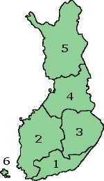
Map of Finland with the Province lines visible (numbered)
(c) adrian.benko, 2005, based on images by (c) helix84, 2005, based on images by (c) Jani Niemenmaa, 2003

|
Permission is granted to copy, distribute and/or modify this document under the terms of the GNU Free Documentation License, Version 1.2 or any later version published by the Free Software Foundation; with no Invariant Sections, no Front-Cover Texts, and no Back-Cover Texts. A copy of the license is included in the section entitled GNU Free Documentation License. |
| This file is licensed under the Creative Commons Attribution-Share Alike 3.0 Unported license. | ||
| ||
| This licensing tag was added to this file as part of the GFDL licensing update. |
File history
Click on a date/time to view the file as it appeared at that time.
| Date/Time | Thumbnail | Dimensions | User | Comment | |
|---|---|---|---|---|---|
| current | 15:37, 12 October 2007 | | 150 × 260 (2 KB) | Skies (talk | contribs) | Map of Finland with the Province lines visible (numbered) (c) adrian.benko, 2005, based on images by (c) helix84, 2005, based on images by (c) Jani Niemenmaa, 2003 {{GFDL}} [[Category:Locator m |
| 15:34, 12 October 2007 |  | 150 × 260 (2 KB) | Skies (talk | contribs) | Map of Finland with the Province lines visible (numbered) (c) adrian.benko, 2005, based on images by (c) helix84, 2005, based on images by (c) Jani Niemenmaa, 2003 {{GFDL}} [[Category:Locator m | |
| 18:32, 27 April 2005 |  | 150 × 261 (17 KB) | Adrian.benko~commonswiki (talk | contribs) | Map of Finland with the Province lines visible (numbered) (c) User:adrian.benko, 2005, based on images by (c) helix84, 2005, based on images by (c) Jani Niemenmaa, 2003 {{GFDL}} |
You cannot overwrite this file.
File usage on Commons
The following 2 pages use this file:
File usage on other wikis
The following other wikis use this file:
- Usage on ast.wikipedia.org
- Usage on be.wikipedia.org
- Usage on br.wikipedia.org
- Usage on bs.wikipedia.org
- Usage on da.wikipedia.org
- Usage on de.wikivoyage.org
- Usage on diq.wikipedia.org
- Usage on el.wikipedia.org
- Usage on en.wikipedia.org
- Usage on eu.wikipedia.org
- Usage on fi.wikipedia.org
- Usage on fi.wikivoyage.org
- Usage on fr.wikipedia.org
- Usage on gag.wikipedia.org
- Usage on he.wikipedia.org
- Usage on hu.wikipedia.org
- Usage on id.wikipedia.org
- Usage on incubator.wikimedia.org
- Usage on ko.wikipedia.org
- Usage on ms.wikipedia.org
- Usage on oc.wikipedia.org
- Usage on pl.wikipedia.org
- Usage on pt.wikipedia.org
- Usage on ro.wikipedia.org
- Usage on ru.wikipedia.org
- Usage on se.wikipedia.org
- Usage on sk.wikipedia.org
- Usage on su.wikipedia.org
- Usage on tg.wikipedia.org
- Usage on vec.wikipedia.org
.png&oldid=478005462)