File:Map of Gascon campaign of 1345.svg
Salta a la navegació
Salta a la cerca

Mida d'aquesta previsualització PNG del fitxer SVG: 552 × 599 píxels. Altres resolucions: 221 × 240 píxels | 442 × 480 píxels | 708 × 768 píxels | 943 × 1.024 píxels | 1.887 × 2.048 píxels | 914 × 992 píxels.
Fitxer original (fitxer SVG, nominalment 914 × 992 píxels, mida del fitxer: 295 Ko)
Llegendes
Llegendes
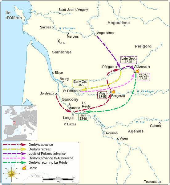
Mapa de la campanya gascona de 1345, emmarcada en la Guerra dels Cent Anys
Resum
[modifica]| Descripció |
English: Map of the Gascon campaign of 1345, part of the Hundred Years' War. This map shows the English and French army movements during the campaign and the most important battles. Català: Mapa de la campanya gascona de 1345, part de la Guerra dels Cent Anys. Aquest mapa mostra els moviments de l'exèrcit anglès i francès durant la campanya i les batalles més importants.
|
||||||||||||||||||||||||
| Data | |||||||||||||||||||||||||
| Font |
Treball propi Derived from; Information from:
|
||||||||||||||||||||||||
| Autor | Goran_tek-en | ||||||||||||||||||||||||
| Permís (Com reutilitzar aquest fitxer) |
This file is licensed under the Creative Commons Attribution-Share Alike 4.0 International license. Reconeixement: Goran tek-en
|
||||||||||||||||||||||||
| Altres versions |
|
||||||||||||||||||||||||
| SVG genesis | Aquesta imatge vectorial ha estat creada amb Inkscape. |
||||||||||||||||||||||||


| Posició de l'objecte | | Aquesta i altres imatges properes a: OpenStreetMap |
|---|


Historial del fitxer
Cliqueu una data/hora per veure el fitxer tal com era aleshores.
| Data/hora | Miniatura | Dimensions | Usuari/a | Comentari | |
|---|---|---|---|---|---|
| actual | 07:49, 2 oct 2023 | | 914 × 992 (295 Ko) | Lalpino (discussió | contribucions) | File uploaded using svgtranslate tool (https://svgtranslate.toolforge.org/). Added translation for ca. |
| 19:53, 9 nov 2021 |  | 914 × 992 (224 Ko) | Goran tek-en (discussió | contribucions) | View box, font size, color deficiency | |
| 17:56, 19 nov 2018 |  | 914 × 993 (128 Ko) | Goran tek-en (discussió | contribucions) | {{Information |description ={{en|1=Map of the Gascon campaign of 1345, part of the Hundred Years' War. This map shows the English and French army movements during the campaign and the most important battles.}} |date = |source ={{Own}}<br> Derived from; * [https://www.openstreetmap.org/#map=8/44.678/-0.324 OSM] Information from: * [https://thehistoryofengland.co.uk/2013/09/29/104-lancaster-and-the-battle-of-auberoche/ The history of England] * {{U|Newm30}} |author... |
No podeu sobreescriure aquest fitxer.
Ús del fitxer
Les 8 pàgines següents utilitzen aquest fitxer:
- User:Goran tek-en/Gallery/2018
- User:Magog the Ogre/Maps of conflicts/2018 November
- User:Magog the Ogre/Maps of conflicts/2021 November
- User:Magog the Ogre/Maps of conflicts/2023 October
- Commons:Graphic Lab/Map workshop/Archive/2018
- File:Map of Gascon campaign of 1345.svg
- File:Map of route of Black Prince chevauchée of 1355.svg
- File:Map of route of Lancaster's chevauchée of 1346.svg
Ús global del fitxer
Utilització d'aquest fitxer en altres wikis:
- Utilització a ca.wikipedia.org
- Utilització a en.wikipedia.org
- Utilització a fr.wikipedia.org
- Utilització a hr.wikipedia.org
- Utilització a it.wikipedia.org
- Utilització a zh.wikipedia.org