File:Map of Gettysburg and vicinity LOC 99446454.jpg
Jump to navigation
Jump to search

Size of this preview: 508 × 600 pixels. Other resolutions: 203 × 240 pixels | 406 × 480 pixels | 650 × 768 pixels | 867 × 1,024 pixels | 1,734 × 2,048 pixels | 15,248 × 18,009 pixels.
Original file (15,248 × 18,009 pixels, file size: 34.02 MB, MIME type: image/jpeg)
Captions
Captions
Add a one-line explanation of what this file represents
Summary
[edit]| Warning | The original file is very high-resolution. It might not load properly or could cause your browser to freeze when opened at full size. |
|---|
| Description |
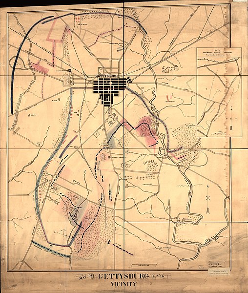
English: Shows Civil-War battle positions in rural districts surrounding Gettysburg (Pa.). Union lines are shown by blue dashes and Confederate lines by red ones. Also shows locations of artillery, significant features of the battlefield, some dwellings with names of residents, vegetation, drainage, roads, and railways. Pen-and-ink, watercolors, and rubber-stamped names. Typewritten label affixed at lower right corner reads: Under direction of Mrs. Georgia Wade McClellan 1898 for her personal use. Rubber-stamped on cloth backing: Exch., Iowa State Dept. of History & Archives, 4/10/42. Imperfect: brittle, water-stained along right side. Includes inset: Site of Gen. Gregg's cavalry operations, three miles east of Gettysburg. Scale 4 1/2 in. = 1 mile. LC Civil War Maps (2nd ed.), 355 Available also through the Library of Congress web site as raster image. Vault |
||
| Title | Map of Gettysburg and vicinity | ||
| Shelf ID | G3824.G3S5 1863 .W4 | ||
| Date | |||
| Source | https://www.loc.gov/item/99446454/ | ||
| Author | Weeks, Gaylord | ||
| Permission (Reusing this file) |
|
||
| Other versions |
|
||
| Location | Pennsylvania · United States · Gettysburg Region | ||
| Part of | Military Battles And Campaigns · American Memory · Civil War Maps · Catalog · Geography And Map Division | ||
| Subject | Maps, Manuscript · Gettysburg Region (Pa.) · Pennsylvania · Gettysburg, Battle Of, Gettysburg, Pa. · Civil War · United States · Maps · Gettysburg Region · History |


Licensing
[edit]
|
This is a faithful photographic reproduction of a two-dimensional, public domain work of art. The work of art itself is in the public domain for the following reason:
The official position taken by the Wikimedia Foundation is that "faithful reproductions of two-dimensional public domain works of art are public domain".
This photographic reproduction is therefore also considered to be in the public domain in the United States. In other jurisdictions, re-use of this content may be restricted; see Reuse of PD-Art photographs for details. | ||||
File history
Click on a date/time to view the file as it appeared at that time.
| Date/Time | Thumbnail | Dimensions | User | Comment | |
|---|---|---|---|---|---|
| current | 06:04, 1 June 2018 | | 15,248 × 18,009 (34.02 MB) | Fæ (talk | contribs) | LOC Maps https://www.loc.gov/item/99446454/ #16736 |
You cannot overwrite this file.
File usage on Commons
The following page uses this file: