File:Map of Greenbrier County, W.Va. - from actual survey LOC 2012593055.jpg
Jump to navigation
Jump to search

Size of this preview: 722 × 600 pixels. Other resolutions: 289 × 240 pixels | 578 × 480 pixels | 925 × 768 pixels | 1,233 × 1,024 pixels | 2,466 × 2,048 pixels | 11,515 × 9,563 pixels.
Original file (11,515 × 9,563 pixels, file size: 11.25 MB, MIME type: image/jpeg)
Captions
Captions
Add a one-line explanation of what this file represents
Summary[edit]
| Warning | The original file is very high-resolution. It might not load properly or could cause your browser to freeze when opened at full size. |
|---|
| Description |
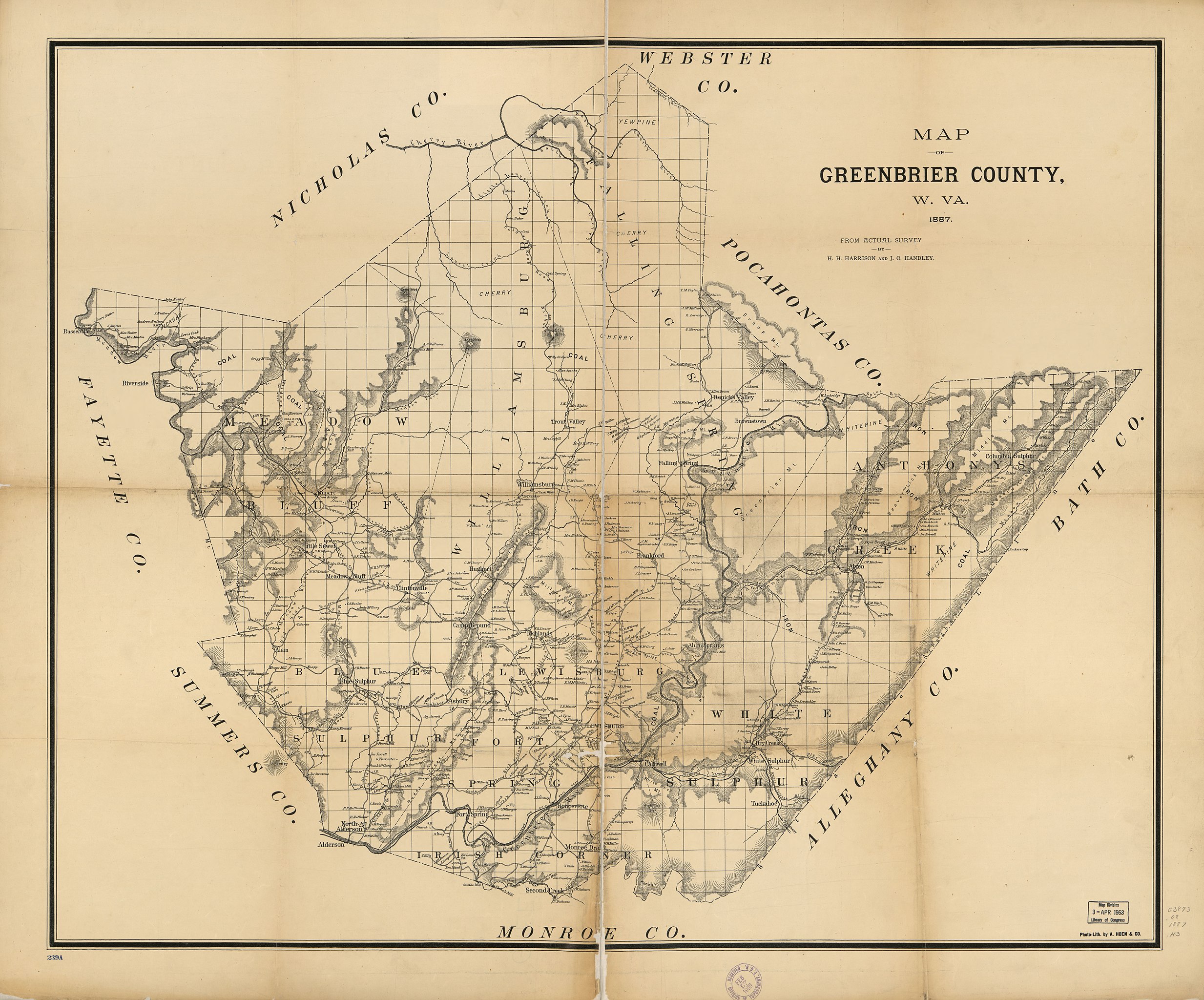
English: Shows administrative boundaries and the names of some residents. Relief shown by hachures. LC Land ownership maps, 1385 Copy imperfect: Darkened, torn and losses along fold-lined, mounted on cloth. In lower left corner stamped in blue ink: 239A. Available also through the Library of Congress Web site as a raster image. |
||
| Title | Map of Greenbrier County, W.Va. : from actual survey | ||
| Shelf ID | G3893.G8G46 1887 .H3 G3893.G8G46 1887 .H3 Copy 2 | ||
| Date | |||
| Source | https://www.loc.gov/item/2012593055/ | ||
| Author | Harrison, H. H.; Handley, J. O.; A. Hoen & Co. | ||
| Permission (Reusing this file) |
|
||
| Location | United States · Greenbrier County · W.Va. · West Virginia | ||
| Part of | American Memory · Catalog · County Landownership Maps · Geography And Map Division · Cultural Landscapes | ||
| Subject | United States · Maps · Greenbrier County · West Virginia · Greenbrier County (W.Va.) · Real Property · Landowners |

Licensing[edit]
|
This is a faithful photographic reproduction of a two-dimensional, public domain work of art. The work of art itself is in the public domain for the following reason:
The official position taken by the Wikimedia Foundation is that "faithful reproductions of two-dimensional public domain works of art are public domain".
This photographic reproduction is therefore also considered to be in the public domain in the United States. In other jurisdictions, re-use of this content may be restricted; see Reuse of PD-Art photographs for details. | ||||
File history
Click on a date/time to view the file as it appeared at that time.
| Date/Time | Thumbnail | Dimensions | User | Comment | |
|---|---|---|---|---|---|
| current | 06:41, 23 May 2018 | | 11,515 × 9,563 (11.25 MB) | Fæ (talk | contribs) | LOC Maps https://www.loc.gov/item/2012593055/ #13618 |
You cannot overwrite this file.
File usage on Commons
There are no pages that use this file.