File:Map of Greene County, Virginia LOC 2012589208.jpg
Jump to navigation
Jump to search
Size of this preview: 595 × 600 pixels. Other resolutions: 238 × 240 pixels | 476 × 480 pixels | 762 × 768 pixels | 1,016 × 1,024 pixels | 2,032 × 2,048 pixels | 7,816 × 7,876 pixels.
Original file (7,816 × 7,876 pixels, file size: 8.71 MB, MIME type: image/jpeg)
Captions
Captions
Add a one-line explanation of what this file represents
Summary
[edit]| Description |
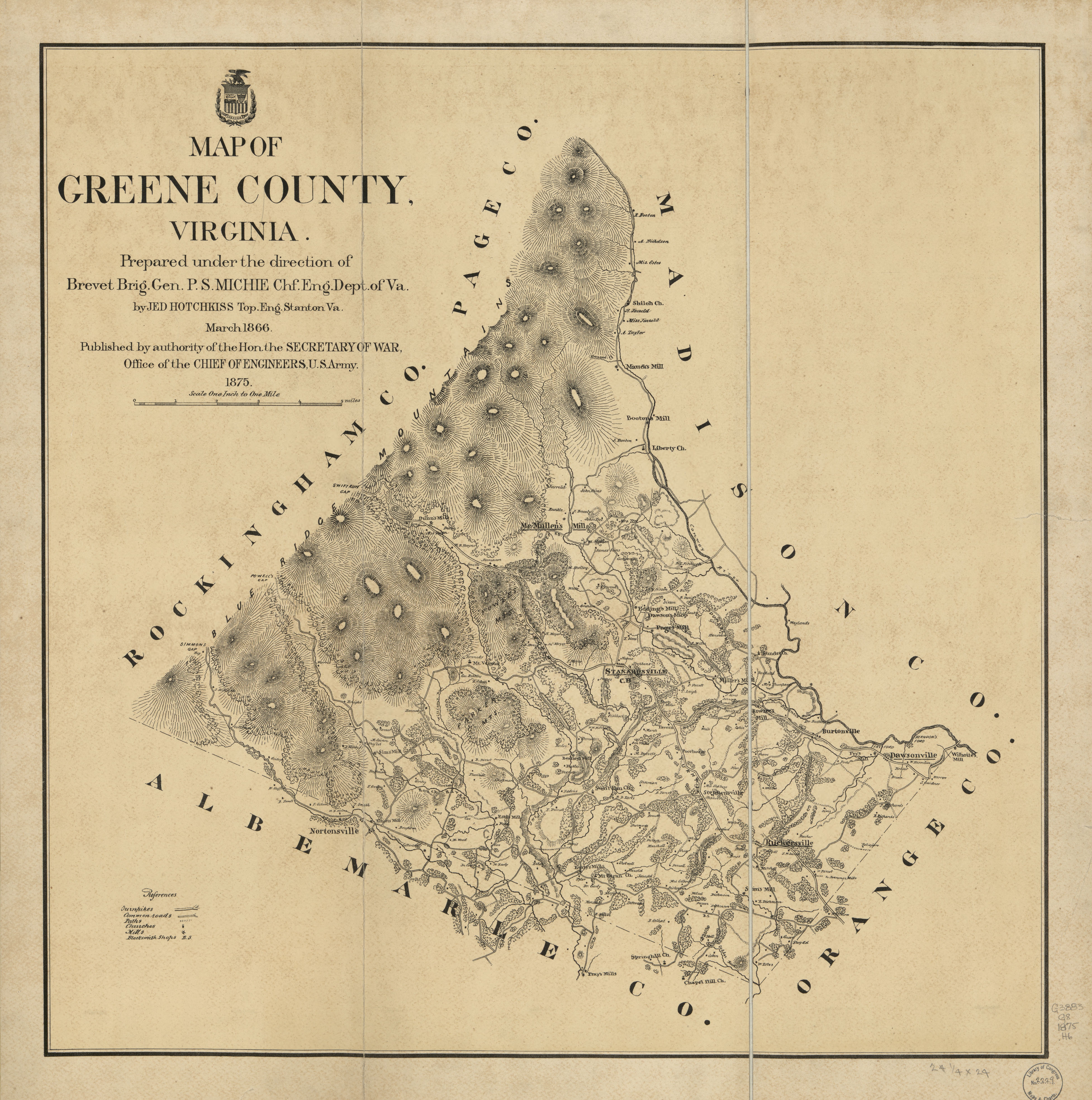
English: Relief shown by hachures. Shows the names of some residents. "March 1866." "Published by the authority of the Hon the Secretary of War, Office of the Chief of Engineers, U.S. Army. 1875." LC Land ownership maps, 1268 Available also through the Library of Congress Web site as a raster image. Copy imperfect: Mounted on cloth backing, torn along fold line. |
||
| Title | Map of Greene County, Virginia | ||
| Shelf ID | G3883.G8G46 1875 .H6 | ||
| Date | |||
| Source | https://www.loc.gov/item/2012589208/ | ||
| Author | Hotchkiss, Jedediah; United States. Army. Office Of The Chief Of Engineers | ||
| Permission (Reusing this file) |
|
||
| Other versions |
|
||
| Location | United States · Greene County · Virginia | ||
| Part of | American Memory · Catalog · County Landownership Maps · Geography And Map Division · Cultural Landscapes | ||
| Subject | Cadastral Maps · Greene County · Virginia · United States · Maps · Greene County (Va.) · Landowners |

Licensing
[edit]
|
This is a faithful photographic reproduction of a two-dimensional, public domain work of art. The work of art itself is in the public domain for the following reason:
The official position taken by the Wikimedia Foundation is that "faithful reproductions of two-dimensional public domain works of art are public domain".
This photographic reproduction is therefore also considered to be in the public domain in the United States. In other jurisdictions, re-use of this content may be restricted; see Reuse of PD-Art photographs for details. | ||||
File history
Click on a date/time to view the file as it appeared at that time.
| Date/Time | Thumbnail | Dimensions | User | Comment | |
|---|---|---|---|---|---|
| current | 21:09, 19 July 2018 | | 7,816 × 7,876 (8.71 MB) | Fæ (talk | contribs) | LOC Maps https://www.loc.gov/item/2012589208/ #5029 |
You cannot overwrite this file.
File usage on Commons
The following page uses this file: