File:Map of Japanese dispositions around Cape Gloucester.jpg
Jump to navigation
Jump to search

Size of this preview: 472 × 600 pixels. Other resolutions: 189 × 240 pixels | 378 × 480 pixels | 604 × 768 pixels | 1,159 × 1,473 pixels.
Original file (1,159 × 1,473 pixels, file size: 401 KB, MIME type: image/jpeg)
Captions
Captions
Add a one-line explanation of what this file represents
| Description |
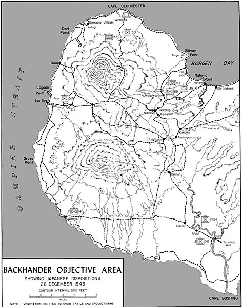
English: Map of Japanese dispositions around Cape Gloucester, late 1943 |
|||
| Date | ||||
| Source | Shaw, Henry I. & Douglas T. Kane (1963) Volume II: Isolation of Rabaul, Washington, D.C.: U.S. Marine Corps Government Printing Office, p. 320 OCLC: 432730347. | |||
| Author | R.F Stibil | |||
| Permission (Reusing this file) |
|

File history
Click on a date/time to view the file as it appeared at that time.
| Date/Time | Thumbnail | Dimensions | User | Comment | |
|---|---|---|---|---|---|
| current | 07:31, 9 February 2018 | | 1,159 × 1,473 (401 KB) | AustralianRupert (talk | contribs) | {{Information |Description ={{en|1=Map of Japanese dispositions around Cape Gloucester, late 1943}} |Source ={{cite book| author= Shaw, Henry I. & Douglas T. Kane | year = 1963 | url = http://www.ibiblio.org/hyperwar/USMC/II/index.html |... |
You cannot overwrite this file.
File usage on Commons
There are no pages that use this file.
File usage on other wikis
The following other wikis use this file:
- Usage on en.wikipedia.org
- Usage on eu.wikipedia.org
- Usage on ru.wikipedia.org