File:Map of North-Brookfield LOC 2003620494.jpg
Jump to navigation
Jump to search

Size of this preview: 523 × 600 pixels. Other resolutions: 209 × 240 pixels | 418 × 480 pixels | 669 × 768 pixels | 893 × 1,024 pixels | 1,785 × 2,048 pixels | 5,254 × 6,027 pixels.
Original file (5,254 × 6,027 pixels, file size: 5.39 MB, MIME type: image/jpeg)
Captions
Captions
Add a one-line explanation of what this file represents
Summary[edit]
| Description |
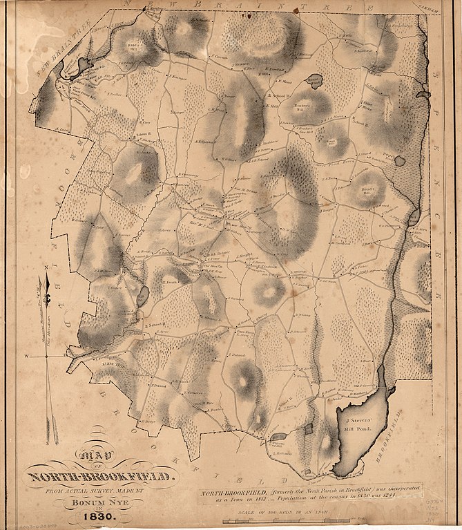
English: Cadastral map showing householders' names. Relief shown by hachures. Note affixed to map at lower right: North-Brookfield (formerly the North Parish in Brookfield) was incorporated as a town in 1812. Population at the census in 1830 was 1,241. Copy imperfect: Darkened, stained, top and bottom margins cut off. Available also through the Library of Congress Web site as a raster image. Acquisitions control no.: 2003-36 |
||
| Title | Map of North-Brookfield | ||
| Shelf ID | G3764.N73 1830 .N9 | ||
| Date | |||
| Source | https://www.loc.gov/item/2003620494/ | ||
| Author | Nye, Bonum | ||
| Permission (Reusing this file) |
|
||
| Other versions |
|
||
| Location | United States · North Brookfield · North Brookfield (Town) · Massachusetts · Town | ||
| Part of | American Memory · Cities And Towns · Catalog · Geography And Map Division | ||
| Subject | North Brookfield (Town) · North Brookfield (Mass. : Town) · United States · Maps · Massachusetts · Real Property |

Licensing[edit]
|
This is a faithful photographic reproduction of a two-dimensional, public domain work of art. The work of art itself is in the public domain for the following reason:
The official position taken by the Wikimedia Foundation is that "faithful reproductions of two-dimensional public domain works of art are public domain".
This photographic reproduction is therefore also considered to be in the public domain in the United States. In other jurisdictions, re-use of this content may be restricted; see Reuse of PD-Art photographs for details. | ||||
File history
Click on a date/time to view the file as it appeared at that time.
| Date/Time | Thumbnail | Dimensions | User | Comment | |
|---|---|---|---|---|---|
| current | 18:29, 20 May 2018 | | 5,254 × 6,027 (5.39 MB) | Fæ (talk | contribs) | LOC Maps https://www.loc.gov/item/2003620494/ #12419 |
You cannot overwrite this file.
File usage on Commons
The following page uses this file: