File:Map of Platt National Park, Murray County, Oklahoma LOC 2018585320.jpg
Jump to navigation
Jump to search

Size of this preview: 800 × 360 pixels. Other resolutions: 320 × 144 pixels | 640 × 288 pixels | 1,024 × 461 pixels | 1,280 × 576 pixels | 2,560 × 1,153 pixels | 9,952 × 4,481 pixels.
Original file (9,952 × 4,481 pixels, file size: 3.53 MB, MIME type: image/jpeg)
Captions
Captions
Add a one-line explanation of what this file represents
Summary
[edit]| Description |
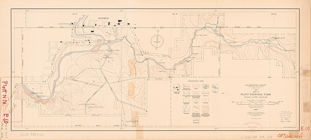
English: Relief shown by contours and spot heights. "Surveyed in 1908." Includes list of conventional signs. LC copy taped along torn line with red and brown pencil writings throughout. Stamped on: Property of C.S. Hammond & Co. Editorial Dept. Date acquired. Available also through the Library of Congress Web site as a raster image. |
||
| Title | Map of Platt National Park, Murray County, Oklahoma | ||
| Shelf ID | G4022.P55 1909 .G4 | ||
| Date | |||
| Source | https://www.loc.gov/item/2018585320/ | ||
| Author | Geological Survey (U.S.) | ||
| Permission (Reusing this file) |
|
||
| Other versions |
|
||
| Location | Platt National Park · United States · Oklahoma · Platt National Park. | ||
| Part of | American Memory · General Maps · Catalog · Geography And Map Division | ||
| Subject | United States · Maps · Oklahoma · Platt National Park (Okla.) · Platt National Park |


Licensing
[edit]
|
This is a faithful photographic reproduction of a two-dimensional, public domain work of art. The work of art itself is in the public domain for the following reason:
The official position taken by the Wikimedia Foundation is that "faithful reproductions of two-dimensional public domain works of art are public domain".
This photographic reproduction is therefore also considered to be in the public domain in the United States. In other jurisdictions, re-use of this content may be restricted; see Reuse of PD-Art photographs for details. | ||||
File history
Click on a date/time to view the file as it appeared at that time.
| Date/Time | Thumbnail | Dimensions | User | Comment | |
|---|---|---|---|---|---|
| current | 10:34, 18 June 2019 | | 9,952 × 4,481 (3.53 MB) | Fæ (talk | contribs) | LOC Maps https://www.loc.gov/item/2018585320/ #11094 |
You cannot overwrite this file.
File usage on Commons
The following page uses this file: