File:Map of Poland and Lithuania (1618-1667).svg
Pāriet uz navigāciju
Pāriet uz meklēšanu

Size of this PNG preview of this SVG file: 750 × 599 pikseļi. Citi izmēri: 300 × 240 pikseļi | 601 × 480 pikseļi | 961 × 768 pikseļi | 1 280 × 1 023 pikseļi | 2 560 × 2 046 pikseļi | 1 205 × 963 pikseļi.
Sākotnējais fails (SVG fails, definētais izmērs 1 205 × 963 pikseļi, faila izmērs: 116 KB)
Captions
Captions
Pievieno vienas rindiņas aprakstu, ko šis fails attēlo
| Apraksts |
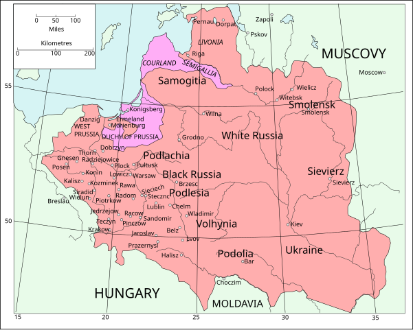
English: Map of Poland and Lithuania following the Union of Lublin in 1569.
|
||
| Datums | (UTC) | ||
| Avots | Map of Poland and Lithuania after the Union of Lublin (1569).jpg | ||
| Autors |
|
||
| SVG veidošana |
|
.jpg)
Šis fails tiek izplatīts saskaņā ar licences Creative Commons Atsauce-Līdzīgi Noteikumi 3.0 Vispārējiem noteikumiem.
- Jūs varat brīvi:
- koplietot – kopēt, izplatīt un pārraidīt darbu
- remiksēt – pielāgot darbu
- Saskaņā ar šādiem nosacījumiem:
- atsaucoties – Tev ir jānorāda autors, saite uz licenci un to, vai veiktas kādas izmaiņas. To var darīt jebkādā saprātīgā veidā, bet ne tādā, kas norādītu, ka licencētājs atbalsta tevi vai veidu, kā tu izmanto šo darbu.
- nemainot licenci – Ja tu miksē, pārveido vai izmanto materiālu, tev savs devums jāpublicē ar to pašu vai saderīgu licenci kā oriģināls.
| File | Type | Details |
|---|---|---|
| File:Polish-Lithuania map (1450-1600).svg | Large SVG | Map showing conflicts and territorial changes on the Polish-Lithuanian—Russian border, 1450–1600 |
| File:Duchy of Prussia.svg | Small SVG | Map of the Duchy of Prussia |
| File:Livonian war map (1558-1560).svg | Small SVG | Map showing campaigns in Livonia, 1558–1560. |
| File:Map of Poland and Lithuania after the Union of Lublin (1569).svg | Large SVG | Map of the w:Polish-Lithuanian Commonwealth after the Union of Lublin in 1569. |
| File:Livonian war map (1570-1577).svg | Small SVG | Map showing areas of Russian and Polish-Lithuanian forces, 1570–1577. |
| File:Campaigns of Stefan Batory.svg | Small SVG | Map of the campaign of Stefan Batory in Livonia (1575–1580). |
| File:Map of Poland and Lithuania in 1600.svg | Small SVG | Map of Livonia in 1600 |
| See also: User:Halibutt/maps, by Halibutt (diskusija · devums). | ||
.svg)
.svg)
.svg)
.svg)
Original upload log
[labot šo sadaļu].svg&action=edit§ion=1)
This image is a derivative work of the following images:
- Map of Poland and Lithuania after the Union of Lublin (1569).jpg licensed with PD-1923, PD-UK-unknown
- 2011-04-12T13:13:53Z Grandiose 1660x1027 (1008090 Bytes) Improve colouring.
- 2011-04-12T12:58:38Z Grandiose 1660x1027 (402170 Bytes) {{Information |Description ={{en|1=Map of Poland and Lithuania following the Union of Lublin in 1569. Taken from "The Cambridge Modern History Atlas", 1912, London: Cambridge University Press. Editors were Sir Adolphus W
Faila hronoloģija
Uzklikšķini uz datums/laiks kolonnā esošās saites, lai apskatītos, kā šis fails izskatījās tad.
| Datums/Laiks | Attēls | Izmēri | Dalībnieks | Komentārs | |
|---|---|---|---|---|---|
| tagadējais | 2011. gada 9. maijs, plkst. 16.44 | | 1 205 × 963 (116 KB) | Grandiose (diskusija | devums) | Done my best on the Swedish coastline |
| 2011. gada 14. aprīlis, plkst. 10.29 |  | 1 205 × 963 (116 KB) | Grandiose (diskusija | devums) | A couple more places, Duchy statuses. | |
| 2011. gada 13. aprīlis, plkst. 17.05 |  | 1 205 × 963 (117 KB) | Grandiose (diskusija | devums) | {{Information |Description={{en|1=Map of Poland and Lithuania following the Union of Lublin in 1569. Adapted from "The Cambridge Modern History Atlas", 1912, London: Cambridge University Press. (See source file for more information.)}} |Source=*[[:File:M |
Šo failu nevar pārrakstīt.
Faila lietojums
Šo failu izmanto šajās 5 lapās:
.svg&redirect=no)
Globālais faila lietojums
Šīs Vikipēdijas izmanto šo failu:
- Izmantojums ca.wikipedia.org
- Izmantojums de.wikipedia.org
- Izmantojums fr.wikipedia.org
- Izmantojums uk.wikipedia.org
.svg&oldid=718557400)