File:Map of Puerto Rico (1801).jpg
Jump to navigation
Jump to search

Size of this preview: 800 × 561 pixels. Other resolutions: 320 × 224 pixels | 640 × 449 pixels | 1,024 × 718 pixels | 1,280 × 897 pixels | 2,560 × 1,795 pixels | 2,994 × 2,099 pixels.
Original file (2,994 × 2,099 pixels, file size: 3.68 MB, MIME type: image/jpeg)
Captions
Captions
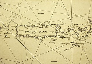
Map of Puerto Rico (1801)
Summary
[edit].jpg&action=edit§ion=1)
| Description |
English: Extracted from "A New and Correct General Chart of the West Indies ... ", published in 1801 by William Heather (London). |
| Date | |
| Source | Digital scan of map (extracted) |
| Author | William Heather |
Licensing
[edit].jpg&action=edit§ion=2)
|
This work is in the public domain in its country of origin and other countries and areas where the copyright term is the author's life plus 100 years or fewer. This work is in the public domain in the United States because it was published (or registered with the U.S. Copyright Office) before January 1, 1929. | |
| This file has been identified as being free of known restrictions under copyright law, including all related and neighboring rights. | |
File history
Click on a date/time to view the file as it appeared at that time.
| Date/Time | Thumbnail | Dimensions | User | Comment | |
|---|---|---|---|---|---|
| current | 13:26, 29 August 2022 | | 2,994 × 2,099 (3.68 MB) | Indies1 (talk | contribs) | Uploaded a work by William Heather from Digital scan of map (extracted) with UploadWizard |
You cannot overwrite this file.
File usage on Commons
There are no pages that use this file.
.jpg&oldid=712404070)