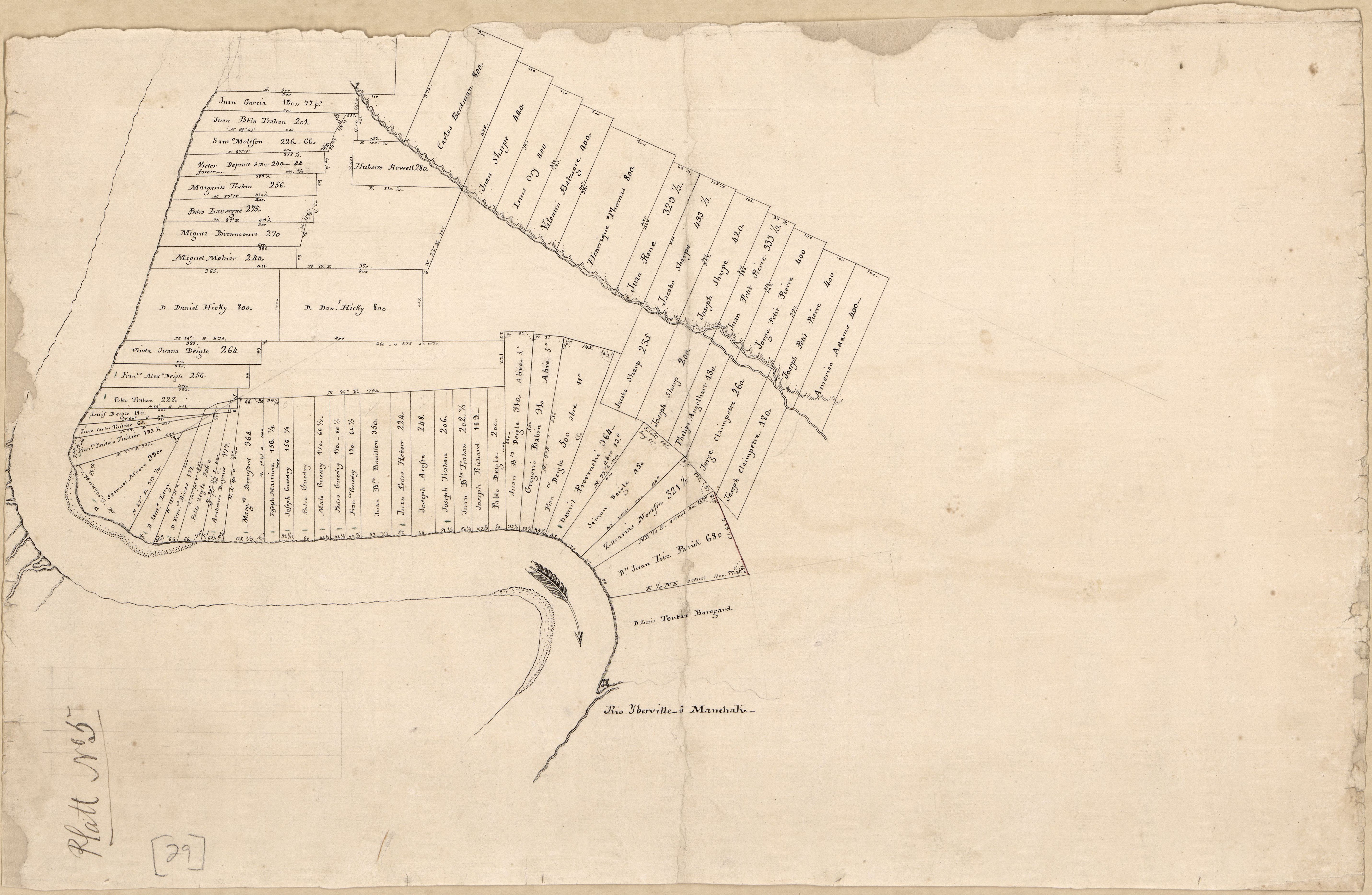
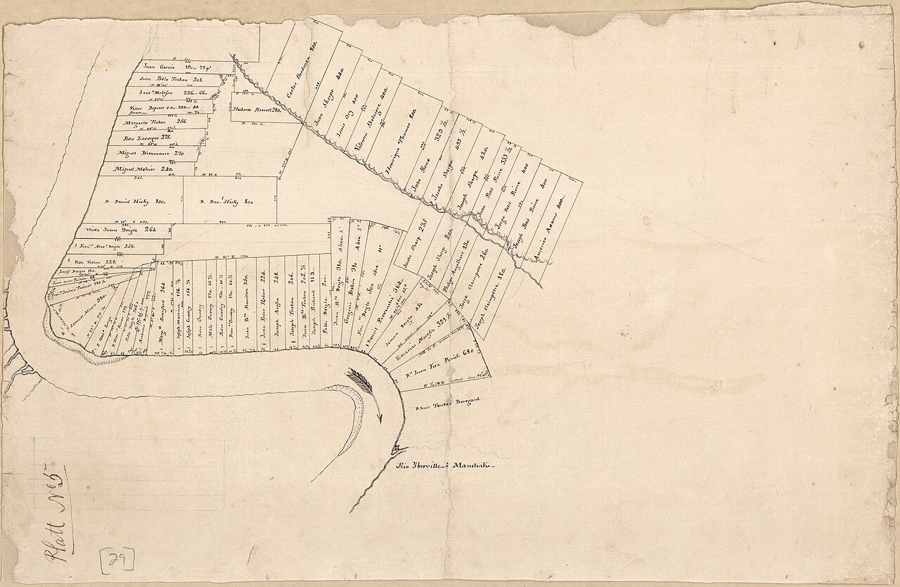
File:Map of a portion of Manchac District, Spanish West Florida. LOC 2013585039.jpg
Jump to navigation
Jump to search
Size of this preview: 800 × 522 pixels. Other resolutions: 320 × 209 pixels | 640 × 418 pixels | 1,024 × 668 pixels | 1,280 × 835 pixels | 2,560 × 1,671 pixels | 5,723 × 3,735 pixels.
Original file (5,723 × 3,735 pixels, file size: 2.87 MB, MIME type: image/jpeg)
Captions
Captions
Add a one-line explanation of what this file represents
Summary
[edit]| Description |
English: Cadastral map. Relief shown by hachures. Title from John R. Hébert's list of maps. Pen-and-ink. Watermarks: Stroud & Co and horn in a shield surmounted by a crown over the year 1802. From the papers of Vicente Sebastián Pintado. Described in: Vicente Sebastián Pintado, Surveyor General of Spanish West Florida, 1805-17 : the man and his maps / by John R. Hébert. Imago mundi, v. 39, pp. 50-72. 1987. p. 64, no. 29. LC Luso-Hispanic World, 924 In lower left corner: Platt no 5. Available also through the Library of Congress Web site as a raster image. |
||
| Title | [Map of a portion of Manchac District, Spanish West Florida]. | ||
| Shelf ID | G4014.M25G46 1805 .M2 | ||
| Date | |||
| Source | https://www.loc.gov/item/2013585039/ | ||
| Author | Pintado, Vicente Sebastián | ||
| Permission (Reusing this file) |
|
||
| Other versions |
|
||
| Location | Manchac (East Baton Rouge Parish) · United States · Lousiana · Manchac · Louisiana · East Baton Rouge Parish | ||
| Part of | American Memory · Catalog · Geography And Map Division · Cultural Landscapes | ||
| Subject | Cadastral Maps · Manchac (East Baton Rouge Parish) · Manchac (East Baton Rouge Parish, La.) · United States · Maps · Real Property · Louisiana · Manuscript Maps |


Licensing
[edit]
|
This is a faithful photographic reproduction of a two-dimensional, public domain work of art. The work of art itself is in the public domain for the following reason:
The official position taken by the Wikimedia Foundation is that "faithful reproductions of two-dimensional public domain works of art are public domain".
This photographic reproduction is therefore also considered to be in the public domain in the United States. In other jurisdictions, re-use of this content may be restricted; see Reuse of PD-Art photographs for details. | ||||
File history
Click on a date/time to view the file as it appeared at that time.
| Date/Time | Thumbnail | Dimensions | User | Comment | |
|---|---|---|---|---|---|
| current | 04:40, 3 June 2018 | | 5,723 × 3,735 (2.87 MB) | Fæ (talk | contribs) | LOC Maps https://www.loc.gov/item/2013585039/ #3121 |
You cannot overwrite this file.
File usage on Commons
The following 3 pages use this file:
._LOC_2013585039.jpg&redirect=no)