File:Map of current Interstates.svg
Aller à la navigation
Aller à la recherche

Taille de cet aperçu PNG pour ce fichier SVG : 689 × 432 pixels. Autres résolutions : 320 × 201 pixels | 640 × 401 pixels | 1 024 × 642 pixels | 1 280 × 803 pixels | 2 560 × 1 605 pixels.
Fichier d’origine (Fichier SVG, nominalement de 689 × 432 pixels, taille : 518 kio)
Légendes
Légendes
Ajoutez en une ligne la description de ce que représente ce fichier
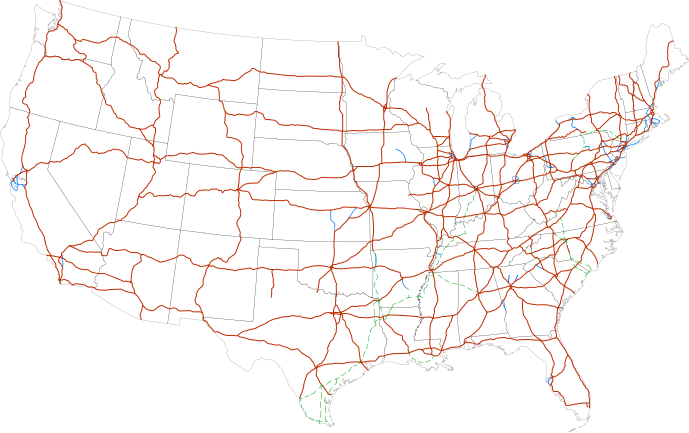
Interstate highway system

|
This file requires updating because: Multiple Interstates and future Interstate are Missing In doing so, you could add a timestamp to the file.
|
Description[modifier]
| Description |
Labels:
One or Two-digit interstates (dark orange line)
Selected three-digit interstates (blue line)
Selected planned interstates (green dashed line) |
| Date | |
| Source | National Atlas |
| Auteur | SPUI |
Conditions d’utilisation[modifier]
| Cette œuvre a été placée dans le domaine public par son auteur, SPUI. Ceci s’applique dans le monde entier. Dans certains pays, ceci peut ne pas être possible ; dans ce cas : |
| Annotations | Cette image est annotée : Voir les annotations sur Wikimedia Commons |
Historique du fichier
Cliquer sur une date et heure pour voir le fichier tel qu'il était à ce moment-là.
| Date et heure | Vignette | Dimensions | Utilisateur | Commentaire | |
|---|---|---|---|---|---|
| actuel | 13 février 2013 à 11:19 | | 689 × 432 (518 kio) | Scott5114 (d | contributions) | Add I-49 in Missouri |
| 11 janvier 2013 à 06:39 |  | 689 × 432 (519 kio) | Agricolae (d | contributions) | add I-376 rebranding north to I-80, planned I-99 from I-80 to I-86 | |
| 2 juillet 2011 à 07:27 |  | 689 × 432 (485 kio) | Jkirkuslamont (d | contributions) | Changed hues to improve legibility for the colour blind | |
| 10 janvier 2010 à 04:36 |  | 689 × 432 (754 kio) | Techman224 (d | contributions) | Made three-dight Interstates near Atlanta, Georgia blue | |
| 23 décembre 2009 à 21:32 |  | 689 × 432 (754 kio) | Clorox (d | contributions) | added I69 | |
| 29 février 2008 à 06:12 |  | 689 × 432 (744 kio) | Alex43223 (d | contributions) | Updated a couple highways | |
| 22 juin 2007 à 02:38 |  | 689 × 432 (687 kio) | Fran Rogers (d | contributions) | Reverted to earlier revision | |
| 22 juin 2007 à 02:37 |  | 689 × 432 (687 kio) | Fran Rogers (d | contributions) | {{spuimap}} Map of the present Interstate Highway System. Base map is [http://www.nationalatlas.gov/printable/images/pdf/reference/genref.pdf] (public domain US Federal Government). *Purple: two-digit *Blue: selected three-digit *Green: selected future ro | |
| 13 juillet 2006 à 16:07 |  | 689 × 432 (687 kio) | SPUI~commonswiki (d | contributions) | {{spuimap}} |
Vous ne pouvez pas remplacer ce fichier.
Utilisations locales du fichier
Les 6 pages suivantes utilisent ce fichier :
Utilisations du fichier sur d’autres wikis
Les autres wikis suivants utilisent ce fichier :
- Utilisation sur an.wikipedia.org
- Utilisation sur ar.wikipedia.org
- Utilisation sur ast.wikipedia.org
- Utilisation sur az.wikipedia.org
- Utilisation sur bg.wikipedia.org
- Utilisation sur bs.wikipedia.org
- Utilisation sur ca.wikipedia.org
- Utilisation sur da.wikipedia.org
- Utilisation sur de.wikipedia.org
- Utilisation sur en.wikipedia.org
- Economy of the United States
- Transportation in the United States
- List of gaps in Interstate Highways
- List of auxiliary Interstate Highways
- Controlled-access highway
- List of business routes of the Interstate Highway System
- User:Master son/US Roads
- User:Master son/US Roads/MTF
- Driving in the United States
- Trucking industry in the United States
- 1956 in the United States
- List of transport megaprojects
- User:Stephen100002/sandbox
- User:Vigneshdm1990/sandbox
- User:44Nifty/sandbox
- User:XanUltra
- Transportation policy of the United States
- Talk:United States/Archive 102
- Portal:Transport/Highway media
- Wikipedia talk:External links/Archive 42
- Wikipedia:Village pump (technical)/Archive 208
- Utilisation sur en.wikibooks.org
- Utilisation sur eo.wikipedia.org
- Utilisation sur es.wikipedia.org
- Utilisation sur et.wikipedia.org
- Utilisation sur eu.wikipedia.org
- Utilisation sur fa.wikipedia.org
- Utilisation sur fi.wikipedia.org
Voir davantage sur l’utilisation globale de ce fichier.