File:Map of current Interstates.svg
跳至導覽
跳至搜尋

此 SVG 檔案的 PNG 預覽的大小:689 × 432 像素。 其他解析度:320 × 201 像素 | 640 × 401 像素 | 1,024 × 642 像素 | 1,280 × 803 像素 | 2,560 × 1,605 像素。
原始檔案 (SVG 檔案,表面大小:689 × 432 像素,檔案大小:518 KB)
說明
說明
添加單行說明來描述出檔案所代表的內容
Interstate highway system
摘要[編輯]
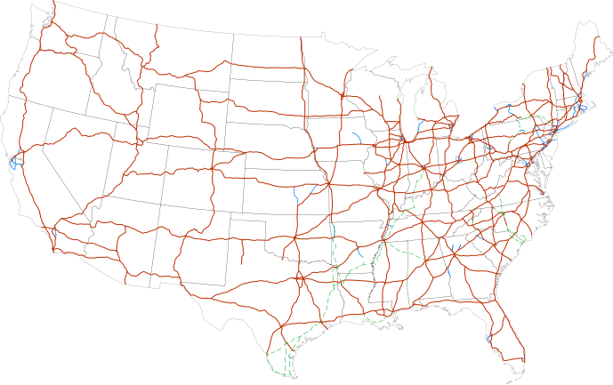
| 描述 |
Labels:
One or Two-digit interstates (dark orange line)
Selected three-digit interstates (blue line)
Selected planned interstates (green dashed line) |
| 日期 | |
| 來源 | National Atlas |
| 作者 | SPUI |
授權條款[編輯]
| 此作品已由其作者,SPUI,釋出至公有領域。此授權條款在全世界均適用。 這可能在某些國家不合法,如果是的話: |
| 註解 | 該圖片含有註解:在維基媒體共享資源上查看註解 |
檔案歷史
點選日期/時間以檢視該時間的檔案版本。
| 日期/時間 | 縮圖 | 尺寸 | 用戶 | 備註 | |
|---|---|---|---|---|---|
| 目前 | 2013年2月13日 (三) 11:19 | | 689 × 432(518 KB) | Scott5114(對話 | 貢獻) | Add I-49 in Missouri |
| 2013年1月11日 (五) 06:39 |  | 689 × 432(519 KB) | Agricolae(對話 | 貢獻) | add I-376 rebranding north to I-80, planned I-99 from I-80 to I-86 | |
| 2011年7月2日 (六) 07:27 |  | 689 × 432(485 KB) | Jkirkuslamont(對話 | 貢獻) | Changed hues to improve legibility for the colour blind | |
| 2010年1月10日 (日) 04:36 |  | 689 × 432(754 KB) | Techman224(對話 | 貢獻) | Made three-dight Interstates near Atlanta, Georgia blue | |
| 2009年12月23日 (三) 21:32 |  | 689 × 432(754 KB) | Clorox(對話 | 貢獻) | added I69 | |
| 2008年2月29日 (五) 06:12 |  | 689 × 432(744 KB) | Alex43223(對話 | 貢獻) | Updated a couple highways | |
| 2007年6月22日 (五) 02:38 |  | 689 × 432(687 KB) | Fran Rogers(對話 | 貢獻) | Reverted to earlier revision | |
| 2007年6月22日 (五) 02:37 |  | 689 × 432(687 KB) | Fran Rogers(對話 | 貢獻) | {{spuimap}} Map of the present Interstate Highway System. Base map is [http://www.nationalatlas.gov/printable/images/pdf/reference/genref.pdf] (public domain US Federal Government). *Purple: two-digit *Blue: selected three-digit *Green: selected future ro | |
| 2006年7月13日 (四) 16:07 |  | 689 × 432(687 KB) | SPUI~commonswiki(對話 | 貢獻) | {{spuimap}} |
無法覆蓋此檔案。
檔案用途
下列6個頁面有用到此檔案:
全域檔案使用狀況
以下其他 wiki 使用了這個檔案:
- an.wikipedia.org 的使用狀況
- ar.wikipedia.org 的使用狀況
- ast.wikipedia.org 的使用狀況
- az.wikipedia.org 的使用狀況
- bg.wikipedia.org 的使用狀況
- bs.wikipedia.org 的使用狀況
- ca.wikipedia.org 的使用狀況
- da.wikipedia.org 的使用狀況
- de.wikipedia.org 的使用狀況
- en.wikipedia.org 的使用狀況
- Economy of the United States
- Transportation in the United States
- List of gaps in Interstate Highways
- List of auxiliary Interstate Highways
- Controlled-access highway
- List of business routes of the Interstate Highway System
- User:Master son/US Roads
- User:Master son/US Roads/MTF
- Driving in the United States
- Trucking industry in the United States
- 1956 in the United States
- List of transport megaprojects
- User:Stephen100002/sandbox
- User:Vigneshdm1990/sandbox
- User:44Nifty/sandbox
- User:XanUltra
- Transportation policy of the United States
- Talk:United States/Archive 102
- Portal:Transport/Highway media
- Wikipedia talk:External links/Archive 42
- Wikipedia:Village pump (technical)/Archive 208
- en.wikibooks.org 的使用狀況
- eo.wikipedia.org 的使用狀況
- es.wikipedia.org 的使用狀況
- et.wikipedia.org 的使用狀況
- eu.wikipedia.org 的使用狀況
- fa.wikipedia.org 的使用狀況
- fi.wikipedia.org 的使用狀況
檢視此檔案的更多全域使用狀況。