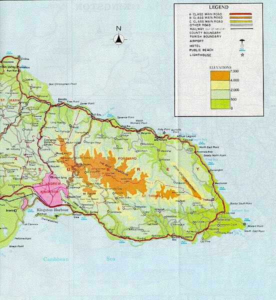
File:Map of eastern jamaica (169055035).jpg
From Wikimedia Commons, the free media repository
Jump to navigation
Jump to search

Size of this preview: 552 × 600 pixels. Other resolutions: 221 × 240 pixels | 442 × 480 pixels | 736 × 800 pixels.
Original file (736 × 800 pixels, file size: 155 KB, MIME type: image/jpeg)
File information
Structured data
Captions
Captions
Add a one-line explanation of what this file represents
Summary[edit]
| DescriptionMap of eastern jamaica (169055035).jpg |
The Center for Global Understanding, where Temple University students stay while in Jamaica, is located on the spit of land between the first of the Yallahs salt ponds and the Caribbean Sea. You can identify the salt ponds on the map above as the southernmost points along the southeastern coast. Drag your cursor across the map and one of the boxes identifies the ponds. The coastal road, in red, wraps around Jamaica's easternmost parishes of St. Thomas and Portland. We explored all four corners of this map: Ocho Rios in the northwest, Kingston in the southwest, Morant Point in the southeast and Long Bay further north along the eastern coastline. Plus we explored parts of the center as we hiked up and over the Cunha Cunha Pass Trail, connecting St. Thomas and Portland the old fashioned way. Morant Bay is the largest town in the parish, and the location of the Women's Center that we have been working in partnership with. |
| Date | |
| Source | map of eastern jamaica |
| Author | Michael L. Dorn from Kansas City, Missouri, United States of America |
| Camera location | 17° 56′ 18.82″ N, 76° 17′ 04.56″ W | View this and other nearby images on: OpenStreetMap |
|---|
Licensing[edit]
This file is licensed under the Creative Commons Attribution-Share Alike 2.0 Generic license.
- You are free:
- to share – to copy, distribute and transmit the work
- to remix – to adapt the work
- Under the following conditions:
- attribution – You must give appropriate credit, provide a link to the license, and indicate if changes were made. You may do so in any reasonable manner, but not in any way that suggests the licensor endorses you or your use.
- share alike – If you remix, transform, or build upon the material, you must distribute your contributions under the same or compatible license as the original.
| This image was originally posted to Flickr by Edu-Tourist at https://flickr.com/photos/55968903@N00/169055035. It was reviewed on 4 November 2020 by FlickreviewR 2 and was confirmed to be licensed under the terms of the cc-by-sa-2.0. |
4 November 2020
File history
Click on a date/time to view the file as it appeared at that time.
| Date/Time | Thumbnail | Dimensions | User | Comment | |
|---|---|---|---|---|---|
| current | 09:59, 4 November 2020 |  | 736 × 800 (155 KB) | JotaCartas (talk | contribs) | Transferred from Flickr via #flickr2commons |
You cannot overwrite this file.
File usage on Commons
There are no pages that use this file.