File:Map of route of Black Prince chevauchée of 1355.svg
Jump to navigation
Jump to search

Size of this PNG preview of this SVG file: 725 × 599 pixels. Other resolutions: 290 × 240 pixels | 581 × 480 pixels | 929 × 768 pixels | 1,239 × 1,024 pixels | 2,478 × 2,048 pixels | 1,049 × 867 pixels.
Original file (SVG file, nominally 1,049 × 867 pixels, file size: 427 KB)
Captions
Captions
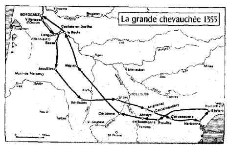
Route of Black Prince's chevauchée of 1355
Summary[edit]
| Description |
English: Map of the route of the Black Prince's chevauchée of 1355, part of the Hundred Years' War. This map shows the Black Prince's movements during the campaign.
|
|||||||||||||||||||||
| Date | ||||||||||||||||||||||
| Source |
Own work Derived from; Information from:
|
|||||||||||||||||||||
| Author | Goran_tek-en | |||||||||||||||||||||
| Permission (Reusing this file) |
This file is licensed under the Creative Commons Attribution-Share Alike 4.0 International license. Attribution: Goran tek-en
|
|||||||||||||||||||||
| Other versions |
|
|||||||||||||||||||||
| SVG development | This vector image was created with Inkscape. |
|||||||||||||||||||||


| Object location | | View this and other nearby images on: OpenStreetMap |
|---|


File history
Click on a date/time to view the file as it appeared at that time.
| Date/Time | Thumbnail | Dimensions | User | Comment | |
|---|---|---|---|---|---|
| current | 15:45, 9 November 2021 | | 1,049 × 867 (427 KB) | Goran tek-en (talk | contribs) | Changed view box, font size |
| 11:26, 1 December 2019 |  | 1,049 × 867 (439 KB) | Goran tek-en (talk | contribs) | {{Information |description ={{en|1=Map of the route of the Black Prince's chevauchée of 1355, part of the Hundred Years' War. This map shows the Black Prince's movements during the campaign}} |date = |source ={{Own}}<br> {{Derived from|Ccaa-spain.png|BlankMap-World gray.svg}} Derived from; * [https://www.openstreetmap.org/#map=7/43.787/1.664 OSM] Information from: * [https://conservancy.umn.edu/bitstream/handle/11299/171443/Madden_umn_0130E_15639.pdf page 10] * [http:/... |
You cannot overwrite this file.
File usage on Commons
The following 6 pages use this file:
File usage on other wikis
The following other wikis use this file:
- Usage on en.wikipedia.org
- Usage on it.wikipedia.org
- Usage on sh.wikipedia.org