File:Map of the Border of the King's Dominion in the Northern America WDL2663.png
Jump to navigation
Jump to search

Size of this preview: 800 × 429 pixels. Other resolutions: 320 × 172 pixels | 640 × 343 pixels | 1,024 × 550 pixels | 1,280 × 687 pixels | 1,908 × 1,024 pixels.
Original file (1,908 × 1,024 pixels, file size: 3.41 MB, MIME type: image/png)
Captions
Captions
Add a one-line explanation of what this file represents
Summary[edit]
| Author |
Русский: Фора, Николас де ла (Год рождения 1730?)
Français : Fora, Nicolas de la (Né 1730 ?)
English: Fora, Nicolas de la (Born 1730?)
中文:Fora, Nicolas de la (出生于 1730 年?)
Português: Fora, Nicolas de la (Nascido em 1730?)
العربية: فورا, نيكولاس دي لا (ولد في 1730؟)
Español: Fora, Nicolás de la (nacido circa 1730) |
| Title |
Русский: Карта границы владений Короля в Северной Америке
Français : Carte de la frontière du Dominion du Roi en Amérique du Nord
English: Map of the Border of the King's Dominion in the Northern America
中文:北美洲金多明尼欧主题乐园边境地图
Português: Mapa da Fronteira do King's Dominion na América do Norte
العربية: خريطة الحدود لممتلكات الملك في أمريكا الشمالية
Español: Mapa de la frontera de los dominios del rey en América del Norte |
| Description |
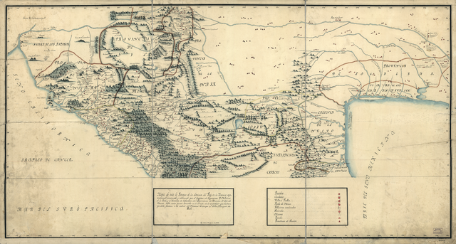
Русский: Эта карта, выполненная чернилами и акварелью, с изображением внутренних провинций Новой Испании (современная Мексика и юго-восток США), является составной картой, созданной на основе карты 1771 года, выполненной Хосе де Уррутия и Николя де ла Фора по результатам предпринятой ими экспедиции с целью изучения расположения военных крепостей и оборонительных сооружений в Новой Испании. В примечании к карте указывается, что это — копия, изготовленная в Мексике 7 августа 1816 года. На карте графически изображены горные цепи, реки, административные границы, крепости, поселения европейцев и коренных жителей, шахты, миссии, береговые линии и береговые ориентиры. В числе географических объектов, отчетливо изображенных на карте, — река Колорадо, Калифорнийский залив, Мексиканский залив и регионы, населенные индейцами апачи.
Français : Cette carte des provinces intérieures de la Nouvelle-Espagne, dessinée à l'encre et à l'aquarelle (aujourd'hui le Mexique et les U.S.A Sud-Ouest) est un composite réalisé à partir d'une carte de 1771 produite par José de Urrútia et Nicolas de la Fora sur la base de leur expédition de 1766-68 pour étudier les presidios (forts royaux) et défenses du nord de la Nouvelle-Espagne. Une note sur la carte indique qu'il s'agit d'une copie réalisée au Mexique le 7 août 1816. La carte comprend une représentation graphique des chaînes de montagnes, cours d'eau, limites administratives, presidios (forts royaux), colonies européennes et américaines, mines, missions, et du littoral et des côtes. Les caractéristiques géographiques clairement indiquées sur la carte comprennent la Rivière Colorado, le Golfe de Californie, le Golfe du Mexique, et les terres habitées par les Indiens Apache.
English: This pen-and-ink and watercolor map of the internal provinces of New Spain (present-day Mexico and the U.S. Southwest) is a composite prepared from a map of 1771 produced by José de Urrútia and Nicolas de la Fora on the basis of their 1766-68 expedition to survey the presidios and defenses of northern New Spain. A note on the map indicates that it is a copy made in Mexico on August 7, 1816. The map includes pictorial representation of mountain ranges, streams, administrative boundaries, presidios, European and Native American settlements, mines, missions, and the coastline and coastal features. Geographic features clearly shown on the map include the Colorado River, the Gulf of California, the Gulf of Mexico, and the lands inhabited by the Apache Indians.
中文:这幅新西班牙(今墨西哥与美国西南部)内部省份的笔墨水彩地图 基于 1771 年何塞·德·苏扎乌鲁蒂亚和尼古拉斯·德拉·弗雷的地图制作而成,他们的地图根据其在 1766-68 年间调查新西班牙北部要塞和防御体系的探险绘制而成。 地图的一处标记说明了这幅地图于 1816 年 8 月 7 日在墨西哥绘制。 地图描绘出山脉、河流、行政边界、要塞、欧洲和本土美洲人定居点、矿山、传教区以及海岸线和沿海特征的图形。 地图清晰描述的地理特征包括科罗拉多河、加利福尼亚湾、墨西哥湾以及阿帕奇印第安人居住的领地。
Português: Este mapa, em bico-de-pena e aquarela, das províncias internas da Nova Espanha (atualmente México e Sudoeste dos EUA) é um compósito feito de um mapa de 1771 produzido por José de Urrútia e Nicolas de la Fora, com base em sua expedição em 1766-68 para pesquisar os presídios e defesas do norte da Nova Espanha. Uma observação no mapa indica que é uma cópia feita no México em 7 de agosto de 1816. O mapa inclui representações pictóricas de cadeias de montanhas, córregos, fronteiras administrativas, presídios, povoados europeus e indígenas, minas, missões e o litoral e aspectos litorâneos. Aspectos geográficos mostrados claramente no mapa incluem o rio Colorado, o Golfo da Califórnia, o Golfo do México e as terras habitadas pelos índios apache.
العربية: إن هذه الخريطة للمقاطعات الداخلية لإسبانيا الجديدة (المكسيك وجنوب غرب الولايات المتحدة حاليا) المرسومة بالريشة والحبر والألوان المائية هي خريطة مركبة من تلك التي أنتجها خوسيه دي أوروتيا ونيكولاس دي لا فورا في 1771 استنادا على البعثة التي قاما بها في 1766-68 لمسح الحصون ومواقع الدفاع في شمال إسبانيا الجديدة. تشير ملاحظة على الخريطة إلى أنها نسخة أُعدت في المكسيك يوم 7 آب 1816. وتتضمن الخريطة تمثيلا مصورا لسلاسل الجبال والجداول والحدود الإدارية والحصون والمستوطنات الأمريكية والأوروبية والمناجم والبعثات والخط الساحلي والمعالم الساحلية. وتشمل المعالم الجغرافية المبينة بوضوح على الخريطة نهر كولورادو وخليج كاليفورنيا وخليج المكسيك والأراضي التي يقطنها هنود الأباتشي.
Español: Este mapa en pluma y tinta, y acuarela de las provincias interiores de Nueva España (actualmente México y el suroeste de EE. UU.) es una composición preparada a partir de un mapa de 1771 elaborado por José de Urrútia y Nicolás de la Fora, basándose en su expedición de 1766-1768 para estudiar los presidios y defensas del norte de Nueva España. Una nota en el mapa indica que se trata de una copia hecha en México el 7 de agosto de 1816. El mapa incluye una representación pictórica de cordilleras, arroyos, límites administrativos, presidios, asentamientos europeos y de nativos americanos, minas, misiones, riberas y accidentes costeros. Los accidentes geográficos que aparecen claramente representados en el mapa incluyen el río Colorado, el golfo de California, el golfo de México, y las islas habitadas por los indios apache. |
| Date | 1816 |
| Medium |
Русский: Карты
Français : Cartes
English: Maps
中文:地图
Português: Mapas
العربية: خرائط
Español: Mapas |
| Dimensions |
English: 1 pen-and-ink and watercolor map, 67 x 127 centimeters |
| Collection |
Русский: Библиотека Конгресса
Français : Bibliothèque du Congrès
English: Library of Congress
中文:国会图书馆
Português: Biblioteca do Congresso
العربية: مكتبة الكونغرس
Español: Biblioteca del Congreso |
| Place of creation |
Русский: Мексика
Français : Mexique
English: Mexico
中文:墨西哥
Português: México
العربية: المكسيك
Español: México |
| Notes |
Original language title: Mapa de Toda la Frontera de los Dominios del Rey en la America Septentrional Русский: Приблизительный масштаб 1:3 375 000
Français : Échelle approximative 1:3 375 000
English: Scale approximately 1:3,375,000
中文:比例尺约为 1:3,375,000
Português: Escala de aproximadamente 1:3,375,000
العربية: المقياس نحو 1:3,375,000
Español: Escala 1:3.375.000 aproximadamente |
| References | http://hdl.loc.gov/loc.wdl/dlc.2663 |
| Source/Photographer |
|
Licensing[edit]
|
This is a faithful photographic reproduction of a two-dimensional, public domain work of art. The work of art itself is in the public domain for the following reason:
The official position taken by the Wikimedia Foundation is that "faithful reproductions of two-dimensional public domain works of art are public domain".
This photographic reproduction is therefore also considered to be in the public domain in the United States. In other jurisdictions, re-use of this content may be restricted; see Reuse of PD-Art photographs for details. | ||||
File history
Click on a date/time to view the file as it appeared at that time.
| Date/Time | Thumbnail | Dimensions | User | Comment | |
|---|---|---|---|---|---|
| current | 11:36, 11 March 2014 | | 1,908 × 1,024 (3.41 MB) | Fæ (talk | contribs) | =={{int:filedesc}}== {{Artwork |artist = |author ={{ru|1=Фора, Николас де ла (Год рождения 1730?)}} {{fr|1=Fora, Nicolas de la (Né 1730 ?)}} {{en|1=Fora, Nicolas de la (Born 1730?)}} {{zh|1=Fora, Nicolas de la (出生于 1730... |
You cannot overwrite this file.
File usage on Commons
The following page uses this file:
File usage on other wikis
The following other wikis use this file:
- Usage on es.wikipedia.org