File:Map of the County of Stephenson Illinois LOC 2013593094.jpg
Jump to navigation
Jump to search

Size of this preview: 634 × 599 pixels. Other resolutions: 254 × 240 pixels | 508 × 480 pixels | 813 × 768 pixels | 1,084 × 1,024 pixels | 2,167 × 2,048 pixels | 17,645 × 16,676 pixels.
Original file (17,645 × 16,676 pixels, file size: 41.06 MB, MIME type: image/jpeg)
Captions
Captions
Add a one-line explanation of what this file represents
Summary
[edit]| Warning | The original file is very high-resolution. It might not load properly or could cause your browser to freeze when opened at full size. |
|---|
| Description |
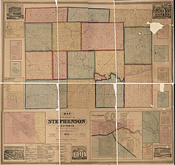
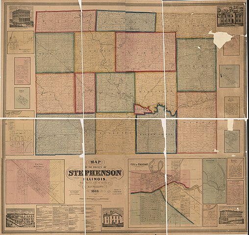
English: "Entered according to Act of Congress in the year 1859 by H.F. Walling in the Clerk's Office of the District Court of the United States for the Southern District of New York." LC Land ownership maps, 132 Available also through the Library of Congress Web site as a raster image. Includes business directories, advertisements, views of residential, public, and commercial buildings. Insets: Orangeville, Onego -- Louisa, West Point -- Loran -- Cedarville -- Lena (West Point) -- City of Freeport -- [illegible due to torn] Grove -- Oneco -- Davis (Rock Run) -- Huron, Erin -- Winslow -- Dakota (Buckeye) -- Stanton (Florence and Loran) -- Nevada (Ridot) LC copy hand colored and accompanied by a title portion cut-out from a second copy. |
||
| Title | Map of the County of Stephenson Illinois | ||
| Shelf ID | G4103.S9G46 1859 .W3 | ||
| Date | |||
| Source | https://www.loc.gov/item/2013593094/ | ||
| Author | Walling, Henry Francis | ||
| Permission (Reusing this file) |
|
||
| Location | Stephenson County · United States · Illinois | ||
| Part of | American Memory · Catalog · County Landownership Maps · Geography And Map Division · Cultural Landscapes | ||
| Subject | Stephenson County · Illinois · United States · Maps · Real Property · Landowners |

Licensing
[edit]
|
This is a faithful photographic reproduction of a two-dimensional, public domain work of art. The work of art itself is in the public domain for the following reason:
The official position taken by the Wikimedia Foundation is that "faithful reproductions of two-dimensional public domain works of art are public domain".
This photographic reproduction is therefore also considered to be in the public domain in the United States. In other jurisdictions, re-use of this content may be restricted; see Reuse of PD-Art photographs for details. | ||||
File history
Click on a date/time to view the file as it appeared at that time.
| Date/Time | Thumbnail | Dimensions | User | Comment | |
|---|---|---|---|---|---|
| current | 06:22, 18 September 2018 | | 17,645 × 16,676 (41.06 MB) | Fæ (talk | contribs) | LOC Maps https://www.loc.gov/item/2013593094/ #31334 |
You cannot overwrite this file.
File usage on Commons
There are no pages that use this file.