File:Map of the Electoral Palatinate (1505)-NL.svg
Jump to navigation
Jump to search

Size of this PNG preview of this SVG file: 440 × 600 pixels. Other resolutions: 176 × 240 pixels | 352 × 480 pixels | 564 × 768 pixels | 751 × 1,024 pixels | 1,503 × 2,048 pixels | 855 × 1,165 pixels.
Original file (SVG file, nominally 855 × 1,165 pixels, file size: 384 KB)
Captions
Captions
Add a one-line explanation of what this file represents
Summary
[edit]-NL.svg&action=edit§ion=1)
| Description |
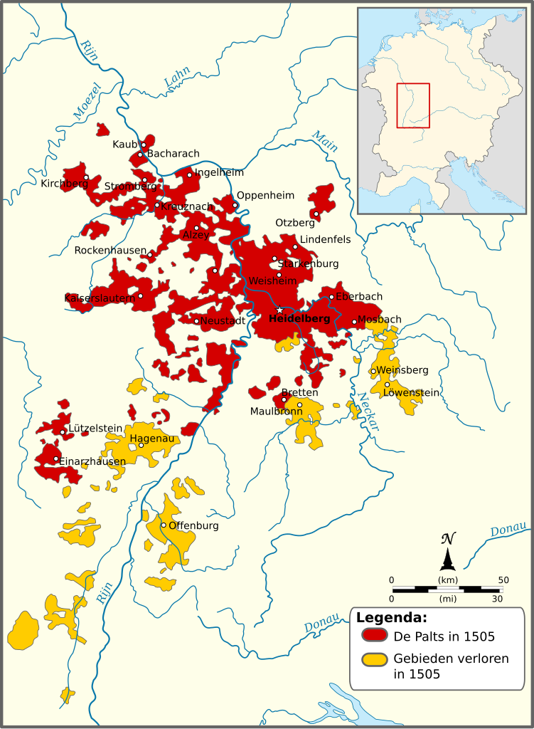
English: Map of the Electorate of the Palatinate in 1505. Areas lost during the War of Succession in Landshut are marked yellow. The Upper-Palatinate is not depicted. Dutch version.
Nederlands: Kaart van de Palts in 1505. De gebieden die verloren werden tijdens de Landshuter Successieoorlog zijn geel afgebeeld. De Opper-Palts is niet weergegeven. |
| Date | |
| Source | Own work, based on a map in Kleine geschichte der Kurpfalz by A. Kohnle |
| Author | Sir Iain |
| Other versions | Derivative works of this file: Map of the Electoral Palatinate (1505)-DE.svg |
-DE.svg)
Licensing
[edit]-NL.svg&action=edit§ion=2)
I, the copyright holder of this work, hereby publish it under the following licenses:

|
Permission is granted to copy, distribute and/or modify this document under the terms of the GNU Free Documentation License, Version 1.2 or any later version published by the Free Software Foundation; with no Invariant Sections, no Front-Cover Texts, and no Back-Cover Texts. A copy of the license is included in the section entitled GNU Free Documentation License. |
This file is licensed under the Creative Commons Attribution-Share Alike 3.0 Unported license.
- You are free:
- to share – to copy, distribute and transmit the work
- to remix – to adapt the work
- Under the following conditions:
- attribution – You must give appropriate credit, provide a link to the license, and indicate if changes were made. You may do so in any reasonable manner, but not in any way that suggests the licensor endorses you or your use.
- share alike – If you remix, transform, or build upon the material, you must distribute your contributions under the same or compatible license as the original.
You may select the license of your choice.
File history
Click on a date/time to view the file as it appeared at that time.
| Date/Time | Thumbnail | Dimensions | User | Comment | |
|---|---|---|---|---|---|
| current | 13:45, 23 October 2010 | | 855 × 1,165 (384 KB) | Sir Iain (talk | contribs) | {{Information |Description={{en|1=Map of the Electoral Palatinate in 1505. Areas lost during the War of Succession in Landshut are marked yellow. The Upper-Palatinate is not depicted. Dutch version.}} {{nl|1=Kaart van de Palts in 1505. De gebieden die ver |
You cannot overwrite this file.
File usage on Commons
The following page uses this file:
File usage on other wikis
The following other wikis use this file:
- Usage on nl.wikipedia.org
-NL.svg&oldid=488950161)