File:Map of the European Long Distance Path E6.png
Aller à la navigation
Aller à la recherche

Taille de cet aperçu : 587 × 600 pixels. Autres résolutions : 235 × 240 pixels | 470 × 480 pixels | 752 × 768 pixels | 1 002 × 1 024 pixels | 1 835 × 1 875 pixels.
Fichier d’origine (1 835 × 1 875 pixels, taille du fichier : 2,65 Mio, type MIME : image/png)
Légendes
Légendes
Ajoutez en une ligne la description de ce que représente ce fichier
Description
[modifier]| Description |
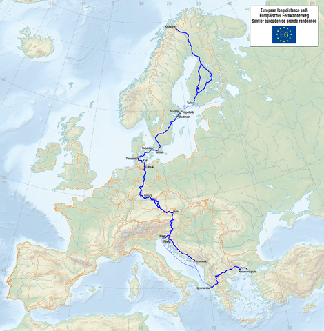
Deutsch: Karte des Europäischen Fernwanderwegs E6
English: Map of the European long distance path E6
Français : Carte du sentier européen de grande randonnée E6 |
| Date | see file history |
| Source |
Travail personnel, using
The information of the contents is from the following sources: |
| Auteur | Maximilian Dörrbecker (Chumwa) |
| Autorisation (Réutilisation de ce fichier) |
Moi, en tant que détenteur des droits d’auteur sur cette œuvre, je la publie sous la licence suivante : Ce fichier est disponible selon les termes de la licence Creative Commons Attribution – Partage dans les Mêmes Conditions 3.0 (non transposée).
Sie dürfen das Bild zu den folgenden Bedingungen nutzen:
|
| Autres versions |
|


|
Cette carte a été créée ou améliorée dans le Kartenwerkstatt (Atelier cartographique allemand). Vous pouvez également y proposer des cartes à améliorer.
|
Historique du fichier
Cliquer sur une date et heure pour voir le fichier tel qu'il était à ce moment-là.
| Date et heure | Vignette | Dimensions | Utilisateur | Commentaire | |
|---|---|---|---|---|---|
| actuel | 14 juin 2015 à 17:15 | | 1 835 × 1 875 (2,65 Mio) | Chumwa (d | contributions) |
Vous ne pouvez pas remplacer ce fichier.
Utilisations locales du fichier
Les 18 pages suivantes utilisent ce fichier :
- User:Chumwa/Gallery
- User:Chumwa/OgreBot/Transport Maps/2015 June 11-20
- User:Chumwa/gallery
- File:Map of the European Long Distance Path E1.png
- File:Map of the European Long Distance Path E10.png
- File:Map of the European Long Distance Path E11.png
- File:Map of the European Long Distance Path E12.png
- File:Map of the European Long Distance Path E2.png
- File:Map of the European Long Distance Path E3.png
- File:Map of the European Long Distance Path E4.png
- File:Map of the European Long Distance Path E5.png
- File:Map of the European Long Distance Path E6.png
- File:Map of the European Long Distance Path E7.png
- File:Map of the European Long Distance Path E8.png
- File:Map of the European Long Distance Path E9.png
- File:Map of the European Long Distance Paths.png
- File:Map of the European long distance paths.svg
- Category:E6 European long distance path
Utilisations du fichier sur d’autres wikis
Les autres wikis suivants utilisent ce fichier :
- Utilisation sur de.wikipedia.org
- Utilisation sur de.wikivoyage.org
- Utilisation sur en.wikipedia.org
- Utilisation sur fi.wikipedia.org
- Utilisation sur fr.wikipedia.org
- Utilisation sur hu.wikipedia.org
- Utilisation sur it.wikipedia.org
- Utilisation sur nl.wikipedia.org
- Utilisation sur pl.wikipedia.org
- Utilisation sur ru.wikipedia.org
- Utilisation sur sl.wikipedia.org
- Utilisation sur www.wikidata.org