File:Map of the Federated States of Micronesia CIA.jpg
跳转到导航
跳转到搜索

本预览的尺寸:740 × 599像素。 其他分辨率:296 × 240像素 | 593 × 480像素 | 948 × 768像素 | 1,200 × 972像素。
原始文件 (1,200 × 972像素,文件大小:312 KB,MIME类型:image/jpeg)
说明
说明
添加一行文字以描述该文件所表现的内容
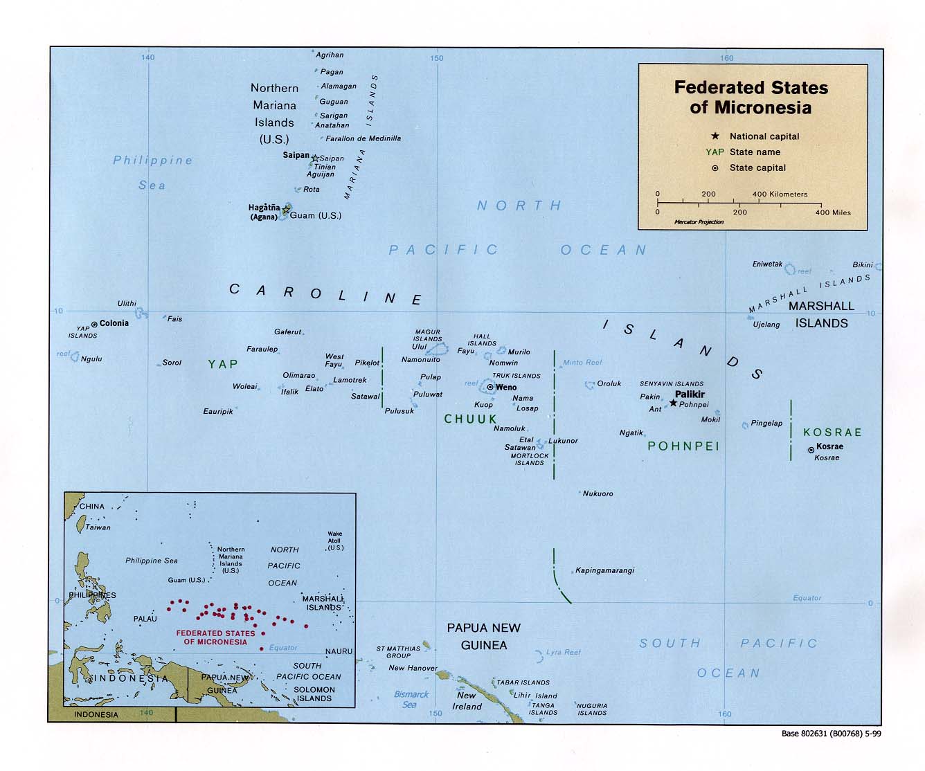
Map of the Federated States of Micronesia showing constituent states
摘要[编辑]
| 描述 |
English: Map of the Federated States of Micronesia — in the Micronesia regon. |
| 日期 | |
| 来源 | Federated States of Micronesia (Political) 1999 from Perry-Castañeda Library Map Collection: Federated States of Micronesia Maps |
| 作者 | U.S. Central Intelligence Agency |
| 授权 (二次使用本文件) |
Public domain |
许可协议[编辑]
| 本图像是中央情报局雇员的职务作品。作为美国联邦政府的作品,本图像或媒体属于公有领域。
|

|
文件历史
点击某个日期/时间查看对应时刻的文件。
| 日期/时间 | 缩略图 | 大小 | 用户 | 备注 | |
|---|---|---|---|---|---|
| 当前 | 2010年9月17日 (五) 15:57 | | 1,200 × 972(312 KB) | Ras67(留言 | 贡献) | rotated 0.22 degree ccw, cropped |
| 2005年1月22日 (六) 09:09 |  | 1,336 × 1,114(140 KB) | Hoshie(留言 | 贡献) | CIA map of FSM. {{PD-PCL|http://www.lib.utexas.edu/maps/islands_oceans_poles/micronesia_pol99.jpg}} |
您不可以覆盖此文件。
文件用途
以下6个页面使用本文件:
全域文件用途
以下其他wiki使用此文件:
- af.wikipedia.org上的用途
- ami.wikipedia.org上的用途
- an.wikipedia.org上的用途
- ar.wikipedia.org上的用途
- ary.wikipedia.org上的用途
- avk.wikipedia.org上的用途
- az.wikipedia.org上的用途
- bg.wikipedia.org上的用途
- bn.wikipedia.org上的用途
- ca.wikipedia.org上的用途
- cs.wikipedia.org上的用途
- cv.wikipedia.org上的用途
- da.wikipedia.org上的用途
- de.wikipedia.org上的用途
- el.wikipedia.org上的用途
- en.wikipedia.org上的用途
- Federated States of Micronesia
- History of the Federated States of Micronesia
- Geography of the Federated States of Micronesia
- Ecclesiastical provinces and dioceses of the Episcopal Church
- User:Jonny-mt/Gallery of current first-level administrative country subdivisions maps
- Outline of the Federated States of Micronesia
- Index of Federated States of Micronesia–related articles
- Isokelekel
- List of islands of the Federated States of Micronesia
- Naval Base Ulithi
- US Naval Base Carolines
- 2023 Micronesian constitutional referendum
- eo.wikipedia.org上的用途
- es.wikipedia.org上的用途
- eu.wikipedia.org上的用途
- fa.wikipedia.org上的用途
- fi.wikipedia.org上的用途
- fr.wikipedia.org上的用途
查看本文件的更多全域用途。