File:Map of the Grand Duchy of Lithuania (pink) and the Crown of the Kingdom of Poland (red) in 1386 - 1434.png
跳至導覽
跳至搜尋

預覽大小:609 × 599 像素。 其他解析度:244 × 240 像素 | 488 × 480 像素 | 781 × 768 像素 | 1,041 × 1,024 像素 | 2,082 × 2,048 像素 | 2,977 × 2,929 像素。
原始檔案 (2,977 × 2,929 像素,檔案大小:2.14 MB,MIME 類型:image/png)
說明
說明
添加單行說明來描述出檔案所代表的內容
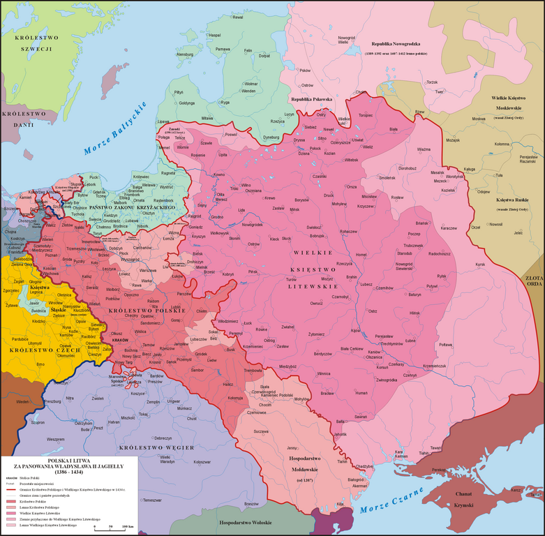
Map of Poland and Lithuania during the reign of Władysław II Jagiełło (1386 - 1434)


|
本圖片是以PNG、GIF或JPEG格式上傳。然而,其中包含的資料或訊息,應該重新建立成可縮放向量圖形(SVG)檔案,以更有效率或更準確的方式儲存。如有可能,請上傳本圖片的SVG格式版本。在上傳之後,請修改維基各姊妹計畫中所有使用舊版圖片的條目(列在圖像連結章節中),替換為新版圖片,並在舊圖片的描述頁中加入{{Vector version available|新圖片名稱.svg}}模板,同時移除本模板。
|
摘要
[編輯]_and_the_Crown_of_the_Kingdom_of_Poland_(red)_in_1386_-_1434.png&action=edit§ion=1)
| 描述 |
English: Map of the Grand Duchy of Lithuania (pink) and the Crown of the Kingdom of Poland (red) under the reign of Władysław II Jagiełło (Jogaila) in 1386 - 1434.
Polski: Mapa Polski i Litwy za panowania Władysława II Jagiełły (1386 - 1434).
Lietuvių: Lietuvos Didžiosios Kunigaikštystės (rožinė) ir Lenkijos Karalystės Karūnos (raudona) žemėlapis valdant Jogailai 1386 - 1434 m. |
| 日期 | |
| 來源 | 我個人以下列物件為基礎來創作: Sienkiewicz, Witold (2006年) (波蘭文) 《 Ilustrowany atlas historii Polski》、華沙: Demart 國際標準書號: 9788374272179. 連線電腦圖書館中心: 838949217. |
| 作者 | Poznaniak |
| 授權許可 (重用此檔案) |
我,本作品的著作權持有者,決定用以下授權條款發佈本作品: 此檔案採用創用CC 姓名標示-相同方式分享 3.0 未在地化版本授權條款。
|
檔案歷史
點選日期/時間以檢視該時間的檔案版本。
_and_the_Crown_of_the_Kingdom_of_Poland_(red)_in_1386_-_1434.png&uselang=zh-hant&dir=prev)
_and_the_Crown_of_the_Kingdom_of_Poland_(red)_in_1386_-_1434.png&uselang=zh-hant&offset=20100220202203)
_and_the_Crown_of_the_Kingdom_of_Poland_(red)_in_1386_-_1434.png&uselang=zh-hant&offset=&limit=20)
_and_the_Crown_of_the_Kingdom_of_Poland_(red)_in_1386_-_1434.png&uselang=zh-hant&offset=&limit=50)
_and_the_Crown_of_the_Kingdom_of_Poland_(red)_in_1386_-_1434.png&uselang=zh-hant&offset=&limit=100)
_and_the_Crown_of_the_Kingdom_of_Poland_(red)_in_1386_-_1434.png&uselang=zh-hant&offset=&limit=250)
_and_the_Crown_of_the_Kingdom_of_Poland_(red)_in_1386_-_1434.png&uselang=zh-hant&offset=&limit=500)
| 日期/時間 | 縮圖 | 尺寸 | 使用者 | 備註 | |
|---|---|---|---|---|---|
| 目前 | 2016年5月12日 (四) 18:34 | | 2,977 × 2,929(2.14 MB) | Poznaniak(留言 | 貢獻) | Rewert po wandalu |
| 2016年5月10日 (二) 17:32 |  | 2,977 × 2,929(2.17 MB) | Julieta39(留言 | 貢獻) | Same map without mistakes : read please the explanations on the discussion page. | |
| 2013年8月16日 (五) 12:46 |  | 2,977 × 2,929(2.14 MB) | Poznaniak(留言 | 貢獻) | Rewert - Mołdawia była lennem i tak też jest zaznaczona | |
| 2013年8月16日 (五) 09:42 |  | 2,977 × 2,929(2.14 MB) | Spiridon Ion Cepleanu(留言 | 貢獻) | Little changes: Moldavia was a vassal (1387-1497), not a part of Polish kingdom; Kilia was on the south side of Chilia arm (Danube delta was moldavian till 1484); Akkerman is the turkish name (1484) of Bialgorod. | |
| 2013年2月24日 (日) 12:48 |  | 2,977 × 2,929(2.14 MB) | Poznaniak(留言 | 貢獻) | popr. | |
| 2013年2月23日 (六) 19:50 |  | 2,977 × 2,929(2.14 MB) | Poznaniak(留言 | 貢獻) | popr. | |
| 2013年2月23日 (六) 16:19 |  | 2,977 × 2,929(2.13 MB) | Poznaniak(留言 | 貢獻) | popr. | |
| 2012年1月1日 (日) 10:54 |  | 2,977 × 2,930(1.61 MB) | Poznaniak(留言 | 貢獻) | Reverted to version as of 20:22, 20 February 2010 | |
| 2011年12月31日 (六) 17:41 |  | 2,963 × 2,916(1.35 MB) | Ras67(留言 | 貢獻) | cropped and optimized | |
| 2010年2月20日 (六) 20:22 |  | 2,977 × 2,930(1.61 MB) | Poznaniak(留言 | 貢獻) | popr. |
無法覆蓋此檔案。
檔案用途
下列6個頁面有用到此檔案:
全域檔案使用狀況
以下其他 wiki 使用了這個檔案:
- ar.wikipedia.org 的使用狀況
- ast.wikipedia.org 的使用狀況
- azb.wikipedia.org 的使用狀況
- az.wikipedia.org 的使用狀況
- ba.wikipedia.org 的使用狀況
- be-tarask.wikipedia.org 的使用狀況
- be.wikipedia.org 的使用狀況
- bg.wikipedia.org 的使用狀況
- ca.wikipedia.org 的使用狀況
- cs.wikipedia.org 的使用狀況
- da.wikipedia.org 的使用狀況
- el.wikipedia.org 的使用狀況
- en.wikipedia.org 的使用狀況
- Władysław II Jagiełło
- Grand Duchy of Lithuania
- Crown of the Kingdom of Poland
- Vytautas
- History of Pomerania
- Natural border
- Pact of Vilnius and Radom
- Union of Horodło
- Union of Grodno (1432)
- Portal:Lithuania
- Polish–Lithuanian–Teutonic War
- Lithuania–Poland relations
- Pomerania during the Early Middle Ages
- List of national founders
- History of Transnistria to 1792
- Duchy of Pomerania-Stolp
- Battle of Grunwald
- History of Poland during the Jagiellonian dynasty
檢視此檔案的更多全域使用狀況。
_and_the_Crown_of_the_Kingdom_of_Poland_(red)_in_1386_-_1434.png)
_and_the_Crown_of_the_Kingdom_of_Poland_(red)_in_1386_-_1434.png&oldid=853177847)