File:Map of the Imperial Circles (1512)-en.png
Aller à la navigation
Aller à la recherche

Pas de plus haute résolution disponible.
Map_of_the_Imperial_Circles_(1512)-en.png (610 × 599 pixels, taille du fichier : 321 kio, type MIME : image/png)
Légendes
Légendes
Ajoutez en une ligne la description de ce que représente ce fichier
Description[modifier]
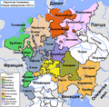
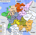
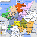
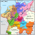
en:User:Silverhelm is the author of this image file.
Its contents are based in part on a map published in the "Historical Atlas" by Prof. William R Shepherd, pub. Henry Holt & Co. (New York, 1911).
Other versions:
[]
1512[modifier]
-
 български (PNG)
 -
 Deutsch (PNG)
 -
 English (PNG)
 -
 français
 -
 magyar (PNG)
-bg.png)
-de.png)
-en.png)
-fr.svg)
.png)
1560[modifier]
-
 Deutsch
 -
 English (original)
 -
 español
 -
 Latina
 -
 Nederlands
-de.svg)
-en.svg)
-es.svg)
-la.svg)
-nl.svg)
-en.png&action=edit§ion=1)
derivative works[modifier]
-en.png&action=edit§ion=2)
Œuvres dérivées de ce fichier : Map of the Imperial Circles (1512)-bg.png
Conditions d’utilisation[modifier]
-en.png&action=edit§ion=3)
Ce fichier est disponible selon les termes de la licence Creative Commons Attribution – Partage dans les Mêmes Conditions 2.5 Générique
- Vous êtes libre :
- de partager – de copier, distribuer et transmettre cette œuvre
- d’adapter – de modifier cette œuvre
- Sous les conditions suivantes :
- paternité – Vous devez donner les informations appropriées concernant l'auteur, fournir un lien vers la licence et indiquer si des modifications ont été faites. Vous pouvez faire cela par tout moyen raisonnable, mais en aucune façon suggérant que l’auteur vous soutient ou approuve l’utilisation que vous en faites.
- partage à l’identique – Si vous modifiez, transformez, ou vous basez sur cette œuvre, vous devez distribuer votre contribution sous la même licence ou une licence compatible avec celle de l’original.
Historique du fichier
Cliquer sur une date et heure pour voir le fichier tel qu'il était à ce moment-là.
| Date et heure | Vignette | Dimensions | Utilisateur | Commentaire | |
|---|---|---|---|---|---|
| actuel | 17 juin 2006 à 01:39 | | 610 × 599 (321 kio) | ~Pyb (d | contributions) | en:User:Silverhelm is the author of this image file. Its contents are based in part on a map published in the "Historical Atlas" by Prof. William R Shepherd, pub. Henry Holt & Co. (New York, 1911). Category:Maps of the Holy Roman Empire |
Vous ne pouvez pas remplacer ce fichier.
Utilisations locales du fichier
Les 30 pages suivantes utilisent ce fichier :
- Atlas of Austria
- Atlas of Belgium
- Atlas of Germany
- Atlas of Luxembourg
- Atlas of Slovenia
- Atlas of Switzerland
- Atlas of the Czech Republic
- Atlas of the Netherlands
- File:Imperial Circles-2005-10-15-en.png (redirection de fichier)
- File:Imperial Circles 1512 en.png (redirection de fichier)
- File:Map of the Imperial Circles (1512)-bg.png
- File:Map of the Imperial Circles (1512)-de.png
- File:Map of the Imperial Circles (1512)-en.png
- File:Map of the Imperial Circles (1512)-fr.svg
- File:Map of the Imperial Circles (1560)-de.svg
- File:Map of the Imperial Circles (1560)-en.svg
- File:Map of the Imperial Circles (1560)-es.svg
- File:Map of the Imperial Circles (1560)-la.svg
- File:Map of the Imperial Circles (1560)-nl.svg
- File:Német-római Birodalom körzetei (1512).png
- Template:Other versions/Map of the Imperial Circles
Utilisations du fichier sur d’autres wikis
Les autres wikis suivants utilisent ce fichier :
- Utilisation sur azb.wikipedia.org
- Utilisation sur az.wikipedia.org
- Utilisation sur be.wikipedia.org
- Utilisation sur bg.wikipedia.org
- История на Германия
- Бургундски имперски окръг
- Имперски окръг
- Баварски имперски окръг
- Австрийски имперски окръг
- Доленрейнски-Вестфалски имперски окръг
- Долносаксонски имперски окръг
- Шаблон:Имперски окръзи на Свещената Римска империя
- Франконски имперски окръг
- Саксонски имперски окръг
- Швабски имперски окръг
- Куррейнски имперски оркръг
- Горносаксонски имперски окръг
- Utilisation sur ca.wikipedia.org
- Utilisation sur cs.wikipedia.org
- Utilisation sur cv.wikipedia.org
- Utilisation sur de.wikipedia.org
- Utilisation sur dsb.wikipedia.org
- Utilisation sur el.wikipedia.org
- Utilisation sur en.wikipedia.org
- History of Germany
- Holy Roman Empire
- Lower Saxony
- Imperial circle
- Talk:Wilhelmus
- History of Silesia
- 1632 series
- Austrian Circle
- Bavarian Circle
- Category:Circles of the Holy Roman Empire
- Burgundian Circle
- Franconian Circle
- Lower Saxon Circle
- Upper Saxon Circle
- User:Silverhelm/Maps
- Electoral Rhenish Circle
- Lower Rhenish–Westphalian Circle
- Swabian Circle
- Upper Rhenish Circle
- House of Schwarzenberg
- Wikipedia:WikiProject Former countries/Holy Roman Empire task force
- Template:Circles of the Holy Roman Empire
- User:Conservativegbd
- Talk:Nicolaus Copernicus/Archive 5
Voir davantage sur l’utilisation globale de ce fichier.
-en.png)
-en.png&oldid=619138038)