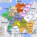
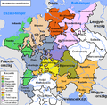
File:Map of the Imperial Circles (1512)-en.png
跳转到导航
跳转到搜索

没有更高的分辨率。
Map_of_the_Imperial_Circles_(1512)-en.png (610 × 599像素,文件大小:321 KB,MIME类型:image/png)
说明
说明
添加一行文字以描述该文件所表现的内容
摘要
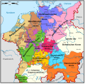
[编辑]en:User:Silverhelm is the author of this image file.
Its contents are based in part on a map published in the "Historical Atlas" by Prof. William R Shepherd, pub. Henry Holt & Co. (New York, 1911).
Other versions:
[]
1512
[编辑]-
 български (PNG)
 -
 català
 -
 Deutsch (PNG)
 -
 English (PNG)
 -
 español
 -
 français
 -
 magyar (PNG)
-bg.png)
-ca.svg&lang=ca)
-de.png)
-en.png)
-es.svg)
-fr.svg)
.png)
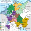
1560
[编辑]-
 català
 -
 Deutsch
 -
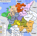
 English (original)
 -
 español
 -
 Latina
 -
 Nederlands
-ca.svg&lang=ca)
-de.svg)
-en.svg)
-es.svg)
-la.svg)
-nl.svg)
-en.png&action=edit§ion=1)
derivative works
[编辑]-en.png&action=edit§ion=2)
Derivative works of this file: Map of the Imperial Circles (1512)-bg.png
许可协议
[编辑]-en.png&action=edit§ion=3)
本文件采用知识共享署名-相同方式共享 2.5 通用许可协议授权。
- 您可以自由地:
- 共享 – 复制、发行并传播本作品
- 修改 – 改编作品
- 惟须遵守下列条件:
- 署名 – 您必须对作品进行署名,提供授权条款的链接,并说明是否对原始内容进行了更改。您可以用任何合理的方式来署名,但不得以任何方式表明许可人认可您或您的使用。
- 相同方式共享 – 如果您再混合、转换或者基于本作品进行创作,您必须以与原先许可协议相同或相兼容的许可协议分发您贡献的作品。
文件历史
点击某个日期/时间查看对应时刻的文件。
| 日期/时间 | 缩略图 | 大小 | 用户 | 备注 | |
|---|---|---|---|---|---|
| 当前 | 2006年6月17日 (六) 01:39 | | 610 × 599(321 KB) | ~Pyb(留言 | 贡献) | en:User:Silverhelm is the author of this image file. Its contents are based in part on a map published in the "Historical Atlas" by Prof. William R Shepherd, pub. Henry Holt & Co. (New York, 1911). Category:Maps of the Holy Roman Empire |
您不可以覆盖此文件。
文件用途
以下33个页面使用本文件:
- Atlas of Austria
- Atlas of Belgium
- Atlas of Germany
- Atlas of Luxembourg
- Atlas of Slovenia
- Atlas of Switzerland
- Atlas of the Czech Republic
- Atlas of the Netherlands
- File:Imperial Circles-2005-10-15-en.png(文件重定向)
- File:Imperial Circles 1512 en.png(文件重定向)
- File:Map of the Imperial Circles (1512)-bg.png
- File:Map of the Imperial Circles (1512)-ca.svg
- File:Map of the Imperial Circles (1512)-de.png
- File:Map of the Imperial Circles (1512)-en.png
- File:Map of the Imperial Circles (1512)-es.svg
- File:Map of the Imperial Circles (1512)-fr.svg
- File:Map of the Imperial Circles (1560)-ca.svg
- File:Map of the Imperial Circles (1560)-de.svg
- File:Map of the Imperial Circles (1560)-en.svg
- File:Map of the Imperial Circles (1560)-es.svg
- File:Map of the Imperial Circles (1560)-la.svg
- File:Map of the Imperial Circles (1560)-nl.svg
- File:Német-római Birodalom körzetei (1512).png
- Template:Other versions/Map of the Imperial Circles
-ca.svg)
-ca.svg)
全域文件用途
以下其他wiki使用此文件:
- azb.wikipedia.org上的用途
- az.wikipedia.org上的用途
- be.wikipedia.org上的用途
- bg.wikipedia.org上的用途
- История на Германия
- Бургундски имперски окръг
- Имперски окръг
- Баварски имперски окръг
- Австрийски имперски окръг
- Доленрейнски-Вестфалски имперски окръг
- Долносаксонски имперски окръг
- Шаблон:Имперски окръзи на Свещената Римска империя
- Франконски имперски окръг
- Саксонски имперски окръг
- Швабски имперски окръг
- Куррейнски имперски оркръг
- Горносаксонски имперски окръг
- cs.wikipedia.org上的用途
- cv.wikipedia.org上的用途
- de.wikipedia.org上的用途
- dsb.wikipedia.org上的用途
- el.wikipedia.org上的用途
- en.wikipedia.org上的用途
- History of Germany
- Holy Roman Empire
- Lower Saxony
- Imperial circle
- Talk:Wilhelmus
- History of Silesia
- 1632 series
- Austrian Circle
- Bavarian Circle
- Category:Circles of the Holy Roman Empire
- Burgundian Circle
- Franconian Circle
- Lower Saxon Circle
- Upper Saxon Circle
- User:Silverhelm/Maps
- Electoral Rhenish Circle
- Lower Rhenish–Westphalian Circle
- Swabian Circle
- Upper Rhenish Circle
- House of Schwarzenberg
- Wikipedia:WikiProject Former countries/Holy Roman Empire task force
- Template:Circles of the Holy Roman Empire
- User:Conservativegbd
- Talk:Nicolaus Copernicus/Archive 5
- History of the Catholic Church in Germany
- User:InforManiac/Navbox04
- Territories of the Holy Roman Empire outside the Imperial Circles
查看此文件的更多全域用途。
-en.png)
-en.png&oldid=619138038)