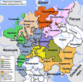
File:Map of the Imperial Circles (1512)-en.png
跳至導覽
跳至搜尋

無更高解析度可提供。
Map_of_the_Imperial_Circles_(1512)-en.png (610 × 599 像素,檔案大小:321 KB,MIME 類型:image/png)
說明
說明
添加單行說明來描述出檔案所代表的內容
摘要
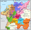
[編輯]en:User:Silverhelm is the author of this image file.
Its contents are based in part on a map published in the "Historical Atlas" by Prof. William R Shepherd, pub. Henry Holt & Co. (New York, 1911).
Other versions:
[]
1512
[編輯]-
 български (PNG)
 -
 català
 -
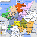
 Deutsch (PNG)
 -
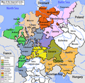 English (PNG)
 -
 español
 -
 français
 -
 magyar (PNG)
-bg.png)
-ca.svg&lang=ca)
-de.png)
-en.png)
-es.svg)
-fr.svg)
.png)
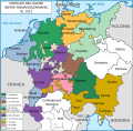
1560
[編輯]-
 català
 -
 Deutsch
 -
 English (original)
 -
 español
 -
 Latina
 -
 Nederlands
-ca.svg&lang=ca)
-de.svg)
-en.svg)
-es.svg)
-la.svg)
-nl.svg)
-en.png&action=edit§ion=1)
derivative works
[編輯]-en.png&action=edit§ion=2)
此檔案衍生的作品: Map of the Imperial Circles (1512)-bg.png
授權條款
[編輯]-en.png&action=edit§ion=3)
此檔案採用創用CC 姓名標示-相同方式分享 2.5 通用版授權條款。
- 您可以自由:
- 分享 – 複製、發佈和傳播本作品
- 重新修改 – 創作演繹作品
- 惟需遵照下列條件:
- 姓名標示 – 您必須指名出正確的製作者,和提供授權條款的連結,以及表示是否有對內容上做出變更。您可以用任何合理的方式來行動,但不得以任何方式表明授權條款是對您許可或是由您所使用。
- 相同方式分享 – 如果您利用本素材進行再混合、轉換或創作,您必須基於如同原先的相同或兼容的條款,來分布您的貢獻成品。
檔案歷史
點選日期/時間以檢視該時間的檔案版本。
| 日期/時間 | 縮圖 | 尺寸 | 使用者 | 備註 | |
|---|---|---|---|---|---|
| 目前 | 2006年6月17日 (六) 01:39 | | 610 × 599(321 KB) | ~Pyb(留言 | 貢獻) | en:User:Silverhelm is the author of this image file. Its contents are based in part on a map published in the "Historical Atlas" by Prof. William R Shepherd, pub. Henry Holt & Co. (New York, 1911). Category:Maps of the Holy Roman Empire |
無法覆蓋此檔案。
檔案用途
下列33個頁面有用到此檔案:
- Atlas of Austria
- Atlas of Belgium
- Atlas of Germany
- Atlas of Luxembourg
- Atlas of Slovenia
- Atlas of Switzerland
- Atlas of the Czech Republic
- Atlas of the Netherlands
- File:Imperial Circles-2005-10-15-en.png (檔案重新導向)
- File:Imperial Circles 1512 en.png (檔案重新導向)
- File:Map of the Imperial Circles (1512)-bg.png
- File:Map of the Imperial Circles (1512)-ca.svg
- File:Map of the Imperial Circles (1512)-de.png
- File:Map of the Imperial Circles (1512)-en.png
- File:Map of the Imperial Circles (1512)-es.svg
- File:Map of the Imperial Circles (1512)-fr.svg
- File:Map of the Imperial Circles (1560)-ca.svg
- File:Map of the Imperial Circles (1560)-de.svg
- File:Map of the Imperial Circles (1560)-en.svg
- File:Map of the Imperial Circles (1560)-es.svg
- File:Map of the Imperial Circles (1560)-la.svg
- File:Map of the Imperial Circles (1560)-nl.svg
- File:Német-római Birodalom körzetei (1512).png
- Template:Other versions/Map of the Imperial Circles
-ca.svg)
-ca.svg)
全域檔案使用狀況
以下其他 wiki 使用了這個檔案:
- azb.wikipedia.org 的使用狀況
- az.wikipedia.org 的使用狀況
- be.wikipedia.org 的使用狀況
- bg.wikipedia.org 的使用狀況
- История на Германия
- Бургундски имперски окръг
- Имперски окръг
- Баварски имперски окръг
- Австрийски имперски окръг
- Доленрейнски-Вестфалски имперски окръг
- Долносаксонски имперски окръг
- Шаблон:Имперски окръзи на Свещената Римска империя
- Франконски имперски окръг
- Саксонски имперски окръг
- Швабски имперски окръг
- Куррейнски имперски оркръг
- Горносаксонски имперски окръг
- cs.wikipedia.org 的使用狀況
- cv.wikipedia.org 的使用狀況
- de.wikipedia.org 的使用狀況
- dsb.wikipedia.org 的使用狀況
- el.wikipedia.org 的使用狀況
- en.wikipedia.org 的使用狀況
- History of Germany
- Holy Roman Empire
- Lower Saxony
- Imperial circle
- Talk:Wilhelmus
- History of Silesia
- 1632 series
- Austrian Circle
- Bavarian Circle
- Category:Circles of the Holy Roman Empire
- Burgundian Circle
- Franconian Circle
- Lower Saxon Circle
- Upper Saxon Circle
- User:Silverhelm/Maps
- Electoral Rhenish Circle
- Lower Rhenish–Westphalian Circle
- Swabian Circle
- Upper Rhenish Circle
- House of Schwarzenberg
- Wikipedia:WikiProject Former countries/Holy Roman Empire task force
- Template:Circles of the Holy Roman Empire
- User:Conservativegbd
- Talk:Nicolaus Copernicus/Archive 5
- History of the Catholic Church in Germany
- User:InforManiac/Navbox04
- Territories of the Holy Roman Empire outside the Imperial Circles
檢視此檔案的更多全域使用狀況。
-en.png)
-en.png&oldid=619138038)