File:Map of the Indian Territory showing Oklahoma country LOC 2013592013.jpg
Jump to navigation
Jump to search

Size of this preview: 800 × 491 pixels. Other resolutions: 320 × 197 pixels | 640 × 393 pixels | 1,024 × 629 pixels | 1,280 × 786 pixels | 2,560 × 1,573 pixels | 12,886 × 7,916 pixels.
Original file (12,886 × 7,916 pixels, file size: 13.77 MB, MIME type: image/jpeg)
Captions
Captions
Add a one-line explanation of what this file represents
Summary[edit]
| Warning | The original file is very high-resolution. It might not load properly or could cause your browser to freeze when opened at full size. |
|---|
| Description |
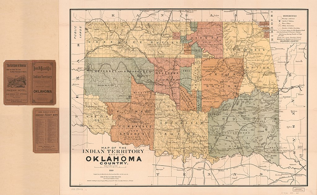
English: Shows townships, military and Indian reservations, and mail service. Relief shown by hachures. Title from cover: Rand, McNally & Co's official map of the Indian Territory. "Entered according to the act of Congress 1884, by Rand, McNally & Co., Map Publishers, Chicago." Available also through the Library of Congress Web site as a raster image. Dealer: Michael D. Heaston. Acquisitions control no. 2005-130 |
||
| Title | Map of the Indian Territory showing Oklahoma country | ||
| Shelf ID | G4020 1889 .R4 | ||
| Date | |||
| Source | https://www.loc.gov/item/2013592013/ | ||
| Author | Rand Mcnally And Company; United States. General Land Office | ||
| Permission (Reusing this file) |
|
||
| Other versions |
|
||
| Location | United States · Oklahoma. · Oklahoma · Indian Territory | ||
| Part of | American Memory · General Maps · Catalog · Geography And Map Division | ||
| Subject | United States · Maps · Oklahoma · Indian Territory · Historical Geography |


Licensing[edit]
|
This is a faithful photographic reproduction of a two-dimensional, public domain work of art. The work of art itself is in the public domain for the following reason:
The official position taken by the Wikimedia Foundation is that "faithful reproductions of two-dimensional public domain works of art are public domain".
This photographic reproduction is therefore also considered to be in the public domain in the United States. In other jurisdictions, re-use of this content may be restricted; see Reuse of PD-Art photographs for details. | ||||
File history
Click on a date/time to view the file as it appeared at that time.
| Date/Time | Thumbnail | Dimensions | User | Comment | |
|---|---|---|---|---|---|
| current | 14:48, 26 May 2019 | | 12,886 × 7,916 (13.77 MB) | Fæ (talk | contribs) | LOC Maps https://www.loc.gov/item/2013592013/ #11374 |
You cannot overwrite this file.
File usage on Commons
The following page uses this file: