File:Map of the Kingdom of Agron of the Ardiaei (English).png
Salta a la navegació
Salta a la cerca

Mida d'aquesta previsualització: 600 × 600 píxels. Altres resolucions: 240 × 240 píxels | 480 × 480 píxels | 768 × 768 píxels | 1.024 × 1.024 píxels | 2.000 × 2.000 píxels.
Fitxer original (2.000 × 2.000 píxels, mida del fitxer: 3,95 Mo, tipus MIME: image/png)
Llegendes
Llegendes
Afegeix una explicació d'una línia del que representa aquest fitxer
Resum[modifica]
.png&action=edit§ion=1)

|
File:Map of the Kingdom of Agron of the Ardiaei (English).svg és una versió vectorial (SVG) d'aquest fitxer. En cas de ser millor, hauria de ser emprada en lloc d'aquesta imatge tramada.
File:Map of the Kingdom of Agron of the Ardiaei (English).png → File:Map of the Kingdom of Agron of the Ardiaei (English).svg
Per a més informació pel que fa als gràfics vectorials, llegiu la transició a SVG en Commons. També hi ha informació quant a la compatibilitat del MediaWiki amb les imatges SVG. |
.svg) |
| Descripció |
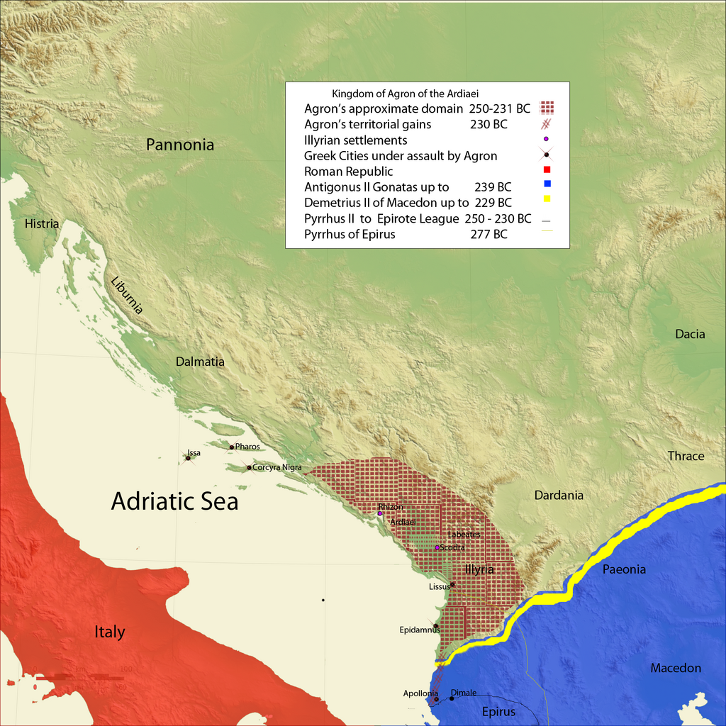
Kingdom of Agron of the Ardiaei and neighboring kingdoms.
|
| Data | |
| Font | Treball propi |
| Autor | Megistias |
| Altres versions |
Derivative works of this file: |
Llicència[modifica]
.png&action=edit§ion=2)
| Jo, el titular del copyright d'aquesta obra, l'allibero al domini públic. Això s'aplica a tot el món. En alguns països això pot no ser legalment possible, en tal cas: Jo faig concessió a tothom del dret d'usar aquesta obra per a qualsevol propòsit, sense cap condició llevat d'aquelles requerides per la llei. |
Historial del fitxer
Cliqueu una data/hora per veure el fitxer tal com era aleshores.
| Data/hora | Miniatura | Dimensions | Usuari/a | Comentari | |
|---|---|---|---|---|---|
| actual | 17:12, 18 feb 2010 | | 2.000 × 2.000 (3,95 Mo) | Megistias (discussió | contribucions) | Legend |
| 11:23, 18 feb 2010 |  | 2.000 × 2.000 (3,95 Mo) | Megistias (discussió | contribucions) | {{Information |Description=Kingdom of Agron of the Ardiaei and neighboring kingdoms. *A History of Macedonia: 336-167 B.C By Nicholas Geoffrey Lempriere Hammond, Frank William Walbank,1988,ISBN-0198148151 *Epire, Illyrie, Macedoine: melanges offerts au pr |
No podeu sobreescriure aquest fitxer.
Ús del fitxer
Les 15 pàgines següents utilitzen aquest fitxer:
.png)
Ús global del fitxer
Utilització d'aquest fitxer en altres wikis:
- Utilització a bg.wikipedia.org
- Utilització a bs.wikipedia.org
- Utilització a de.wikipedia.org
- Utilització a el.wikipedia.org
- Utilització a en.wikipedia.org
- Utilització a es.wikipedia.org
- Utilització a fa.wikipedia.org
- Utilització a fi.wikipedia.org
- Utilització a fr.wikipedia.org
- Utilització a fy.wikipedia.org
- Utilització a gl.wikipedia.org
- Utilització a hr.wikipedia.org
- Utilització a it.wikipedia.org
- Utilització a ja.wikipedia.org
- Utilització a ka.wikipedia.org
- Utilització a ko.wikipedia.org
- Utilització a la.wikipedia.org
- Utilització a lt.wikipedia.org
- Utilització a lv.wikipedia.org
- Utilització a mg.wikipedia.org
- Utilització a mk.wikipedia.org
- Utilització a nl.wikipedia.org
- Utilització a nrm.wikipedia.org
- Utilització a oc.wikipedia.org
- Utilització a pl.wikipedia.org
- Utilització a ro.wikipedia.org
- Utilització a ru.wikipedia.org
- Utilització a sh.wikipedia.org
- Utilització a simple.wikipedia.org
- Utilització a sl.wikipedia.org
- Utilització a sr.wikipedia.org
- Utilització a tr.wikipedia.org
- Utilització a uk.wikipedia.org
- Utilització a xmf.wikipedia.org
.png&oldid=698042222)
Categories:
- Maps showing 3rd-century BC history
- Maps of the ancient Kingdom of Illyria
- Antigonus II Gonatas
- Antigonid dynasty
- 240s BC
- 250s BC
- Maps of the Hellenistic world
- Maps of the history of the ancient Balkans
- Maps of the history of Albania in ancient times
- Maps of the history of Montenegro in ancient times
- Maps of the history of Kosovo in ancient times
- Agron of Illyria