File:Map of the Kingdom of Agron of the Ardiaei (English).png
Sautar la navigacion
Sautar la recèrca

Talha d'aquesta previsualizacion: 600 × 600 pixèls. Autras resolucions : 240 × 240 pixèls | 480 × 480 pixèls | 768 × 768 pixèls | 1 024 × 1 024 pixèls | 2 000 × 2 000 pixèls.
Fichièr d'origina (2 000 × 2 000 pixèl, talha del fichièr: 3,95 Mo, tipe MIME: image/png)
Llegendes
Llegendes
Afegeix una explicació d'una línia del que representa aquest fitxer
Descripcion
[modificar].png&action=edit§ion=1)

|
Una version vectoriala d'aqueste imatge existís, dins lo format "SVG".
Deuriá èsser utilizada a la plaça de la presenta version per d'afichatges en dimensions mai grandas o que necessitan una resolucion melhora. File:Map of the Kingdom of Agron of the Ardiaei (English).png → File:Map of the Kingdom of Agron of the Ardiaei (English).svg
Per mai d'entresenhas suls imatges vectorials, consultatz la pagina de transicion de Commons cap al format SVG. Vejatz tanben las entresenhas a prepaus del biais que lo logicial MediaWiki supòrta los imatges al format SVG. |
.svg) |
| Descripcion |
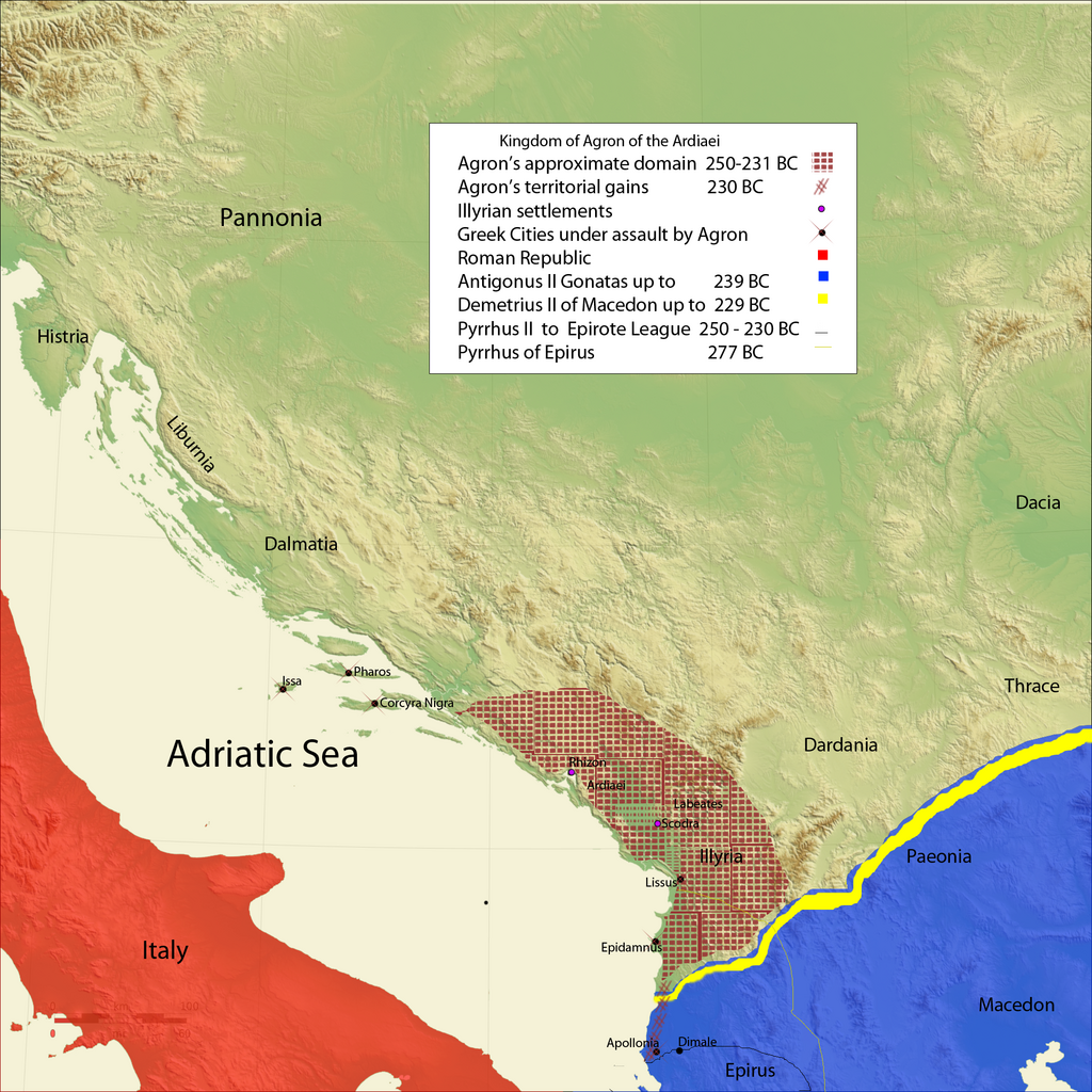
Kingdom of Agron of the Ardiaei and neighboring kingdoms.
|
| Data | |
| Font | Trabalh personal |
| Autor | Megistias |
| Autras versions |
Derivative works of this file: |
Publicat jos licéncia(s)
[modificar].png&action=edit§ion=2)
| Jo, el titular del copyright d'aquesta obra, l'allibero al domini públic. Això s'aplica a tot el món. En alguns països això pot no ser legalment possible, en tal cas: Jo faig concessió a tothom del dret d'usar aquesta obra per a qualsevol propòsit, sense cap condició llevat d'aquelles requerides per la llei. |
Istoric del fichièr
Clicar sus una data e una ora per veire lo fichièr tal coma èra a aqueste moment
| Data e ora | Miniatura | Dimensions | Utilizaire | Comentari | |
|---|---|---|---|---|---|
| actual | 18 febrièr de 2010 a 17.12 | | 2 000 × 2 000 (3,95 Mo) | Megistias (discussion | contribucions) | Legend |
| 18 febrièr de 2010 a 11.23 |  | 2 000 × 2 000 (3,95 Mo) | Megistias (discussion | contribucions) | {{Information |Description=Kingdom of Agron of the Ardiaei and neighboring kingdoms. *A History of Macedonia: 336-167 B.C By Nicholas Geoffrey Lempriere Hammond, Frank William Walbank,1988,ISBN-0198148151 *Epire, Illyrie, Macedoine: melanges offerts au pr |
Podètz pas remplaçar aqueste fichièr.
Paginas que contenon lo fichièr
Las paginas çaijós compòrtan aqueste imatge :
.png)
Usatge global del fichièr
Los autres wikis seguents utilizan aqueste imatge :
- Utilizacion sus bg.wikipedia.org
- Utilizacion sus bs.wikipedia.org
- Utilizacion sus de.wikipedia.org
- Utilizacion sus el.wikipedia.org
- Utilizacion sus en.wikipedia.org
- Utilizacion sus es.wikipedia.org
- Utilizacion sus fa.wikipedia.org
- Utilizacion sus fi.wikipedia.org
- Utilizacion sus fr.wikipedia.org
- Utilizacion sus fy.wikipedia.org
- Utilizacion sus gl.wikipedia.org
- Utilizacion sus hr.wikipedia.org
- Utilizacion sus it.wikipedia.org
- Utilizacion sus ja.wikipedia.org
- Utilizacion sus ka.wikipedia.org
- Utilizacion sus ko.wikipedia.org
- Utilizacion sus la.wikipedia.org
- Utilizacion sus lt.wikipedia.org
- Utilizacion sus lv.wikipedia.org
- Utilizacion sus mg.wikipedia.org
- Utilizacion sus mk.wikipedia.org
- Utilizacion sus nl.wikipedia.org
- Utilizacion sus nrm.wikipedia.org
- Utilizacion sus oc.wikipedia.org
- Utilizacion sus pl.wikipedia.org
- Utilizacion sus ro.wikipedia.org
- Utilizacion sus ru.wikipedia.org
- Utilizacion sus sh.wikipedia.org
- Utilizacion sus simple.wikipedia.org
- Utilizacion sus sl.wikipedia.org
- Utilizacion sus sr.wikipedia.org
- Utilizacion sus tr.wikipedia.org
- Utilizacion sus uk.wikipedia.org
- Utilizacion sus xmf.wikipedia.org
.png&oldid=698042222)
Categorias :
- Maps showing 3rd-century BC history
- Maps of the ancient Kingdom of Illyria
- Antigonus II Gonatas
- Antigonid dynasty
- 240s BC
- 250s BC
- Maps of the Hellenistic world
- Maps of the history of the ancient Balkans
- Maps of the history of Albania in ancient times
- Maps of the history of Montenegro in ancient times
- Maps of the history of Kosovo in ancient times
- Agron of Illyria