File:Map of the MENA region in 1798.svg
Перейти к навигации
Перейти к поиску

Размер этого PNG-превью для исходного SVG-файла: 800 × 522 пкс. Другие разрешения: 320 × 209 пкс | 640 × 417 пкс | 1024 × 668 пкс | 1280 × 835 пкс | 2560 × 1669 пкс | 1543 × 1006 пкс.
Исходный файл (SVG-файл, номинально 1543 × 1006 пкс, размер файла: 528 КБ)
Краткие подписи
Краткие подписи
Добавьте однострочное описание того, что собой представляет этот файл
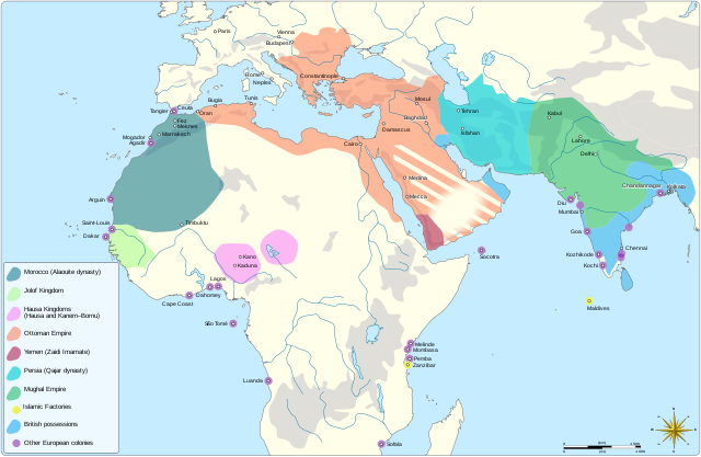
The MENA region in 1798
Краткое описание
[править]| Описание |
English: Map showing the political entities of the Middle East and North Africa in 1798, namely: the Alaouite dynasty, the Kingdom of Jolof, the Hausa Kingdoms, the Ottoman empire, the Yemeni Zaidi State, the Qajar dynasty and the Mughal Empire. |
| Дата | |
| Источник |
Собственная работа Information from: |
| Автор | Goran tek-en, following request by and knowledge from Flaspec |
| Права (Повторное использование этого файла) |
Этот файл доступен по лицензии Creative Commons Attribution-Share Alike 4.0 International Атрибуция: Goran tek-en
|
| Другие версии |
|
| SVG‑разработка | Это векторное изображение было создано с помощью Inkscape. |

| Местоположение объекта | | Это и другие изображения по их местоположению на OpenStreetMap |
|---|

История файла
Нажмите на дату/время, чтобы увидеть версию файла от того времени.
| Дата/время | Миниатюра | Размеры | Участник | Примечание | |
|---|---|---|---|---|---|
| текущий | 10:03, 4 мая 2021 | | 1543 × 1006 (528 КБ) | Goran tek-en (обсуждение | вклад) | Change in legend requested by Flaspec |
| 09:21, 3 мая 2021 |  | 1543 × 1006 (528 КБ) | Goran tek-en (обсуждение | вклад) | {{Information |description ={{en|Map showing the political entities of the Middle East and North Africa in 1798.}} |date =2021-05-03 |source ={{Own}}<br> {{Derived from|امتداد الدولة العلوية سنة 1798م.png|BlankMap-World-Compact.svg}} Information from: * [http://medias.sciences-po.fr/Lexpansion_europeenne_1798/medias/domain2/media0/133-0glgaklmem-whr.jpg 1798] * {{U|Flaspec}} |author =Goran tek-en, following request by... |
Вы не можете перезаписать этот файл.
Использование файла
Следующие 2 страницы используют этот файл:
Глобальное использование файла
Данный файл используется в следующих вики:
- Использование в ar.wikipedia.org
- Использование в fr.wikipedia.org
Метаданные
Категории:
- Color deficiency ok
- Maps of the history of the Middle East
- Maps showing history of Africa
- Maps of the history of Morocco
- Maps of the Jolof Kingdom
- Hausa people
- Maps of the Ottoman Empire
- Historical maps of Yemen
- Maps of the history of Iran
- SVG maps of the history of India
- Maps of the history of Sri Lanka
- SVG maps of the British Empire
- Maps of colonial Africa
- Maps of the Alaouite Sultanate
- Maps of the history of the Ottoman Empire in the 1790s
- Zaydi imams of Yemen
- Qajar dynasty
- Maps of the Mughal Empire
- SVG maps of the world showing history
- 1798