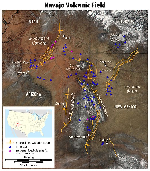
File:Map of the Navajo Volcanic Fields.jpg
Jump to navigation
Jump to search

Size of this preview: 523 × 599 pixels. Other resolutions: 209 × 240 pixels | 419 × 480 pixels | 670 × 768 pixels | 893 × 1,024 pixels | 1,280 × 1,467 pixels.
Original file (1,280 × 1,467 pixels, file size: 568 KB, MIME type: image/jpeg)
Categories:
- Geographic Overlays
- Geological maps of the United States
- Geography of the Southwestern United States
- Mountain ranges of Colorado
- Mountain ranges of New Mexico
- Mountain ranges of Arizona
- Mountain ranges of Utah
- Colorado Plateau region of Colorado
- Colorado Plateau region of New Mexico
- San Juan River (Colorado River tributary)
- Gallup, New Mexico
- Colorado Plateau region of Arizona
- Colorado Plateau region of Utah
- Agathla Peak
- Maps of Navajo Volcanic Field
- Maps of Canyon de Chelly National Monument
- Carrizo Mountains
- Lukachukai Mountains
- Chuska Mountains
- Four Corners (United States)
- Maps of Monument Valley
- Window Rock, Arizona
- Navajo Volcanic Field
- Shiprock
- Landforms on the Navajo Nation
- Kayenta, Arizona
- Black Mesa (Apache-Navajo Counties, Arizona)
- Laguña Creek
- U.S. Route 160 in Arizona
- Chinle, Arizona
- Chinle Creek
- Beautiful Valley (Arizona)
- Defiance Plateau
- Defiance Uplift
- Puerco River
- Plateaus of Arizona
- Plateaus of New Mexico
- Rivers of Arizona
- Rivers of New Mexico
- Rivers of Utah
- Rivers of Colorado
- Apache County, Arizona
- McKinley County, New Mexico
- Maps of volcanoes in the United States
- Volcanoes in Utah
- Volcanoes in Colorado
- Volcanoes in Arizona
- Volcanic fields in New Mexico
- Volcanology of Arizona
- Volcanology of Colorado
- Extensional regime
- Geological maps of Utah
- Geological maps of Arizona
- Geological maps of Colorado
- Geological maps of New Mexico
- Monoclines in the United States
- Mafic rocks in Utah
- Ultramafic rocks in Utah


