File:Map of the Navajo Volcanic Fields.jpg
跳转到导航
跳转到搜索

本预览的尺寸:523 × 599像素。 其他分辨率:209 × 240像素 | 419 × 480像素 | 670 × 768像素 | 893 × 1,024像素 | 1,280 × 1,467像素。
原始文件 (1,280 × 1,467像素,文件大小:568 KB,MIME类型:image/jpeg)
说明
说明
添加一行文字以描述该文件所表现的内容
| 描述 |
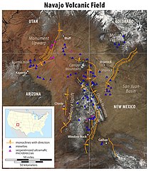
Deutsch: Karte der Navajo Volcanic Fields
English: Map of the Navajo Volcanic Field
|
|||
| 日期 | ||||
| 来源 |
自己的作品, using the following information:
|
|||
| 作者 | Maximilian Dörrbecker (Chumwa) | |||
| 授权 (二次使用本文件) |
我,本作品著作权人,特此采用以下许可协议发表本作品: 本文件采用知识共享署名-相同方式共享 2.5 通用许可协议授权。
Sie dürfen das Bild zu den folgenden Bedingungen nutzen:
|
|||
| 其他版本 |
|


文件历史
点击某个日期/时间查看对应时刻的文件。
| 日期/时间 | 缩略图 | 大小 | 用户 | 备注 | |
|---|---|---|---|---|---|
| 当前 | 2011年5月24日 (二) 14:49 | | 1,280 × 1,467(568 KB) | Chumwa(留言 | 贡献) | {{Information |Description= *{{de|Karte der Navajo Volcanic Fields :Zur Erläuterung: :* Monoklinalen mit Richtung :* Minette :* serpentinisierte [[ |
您不可以覆盖此文件。
文件用途
以下3个页面使用本文件:
全域文件用途
以下其他wiki使用此文件:
- arz.wikipedia.org上的用途
- ceb.wikipedia.org上的用途
- cs.wikipedia.org上的用途
- de.wikipedia.org上的用途
- en.wikipedia.org上的用途
- fa.wikipedia.org上的用途
- fr.wikipedia.org上的用途
- lld.wikipedia.org上的用途
- vi.wikipedia.org上的用途
- www.wikidata.org上的用途
- zh.wikipedia.org上的用途
元数据
分类:
- Geographic Overlays
- Geological maps of the United States
- Geography of the Southwestern United States
- Mountain ranges of Colorado
- Mountain ranges of New Mexico
- Mountain ranges of Arizona
- Mountain ranges of Utah
- Colorado Plateau region of Colorado
- Colorado Plateau region of New Mexico
- San Juan River (Colorado River tributary)
- Gallup, New Mexico
- Colorado Plateau region of Arizona
- Colorado Plateau region of Utah
- Agathla Peak
- Maps of Navajo Volcanic Field
- Maps of Canyon de Chelly National Monument
- Carrizo Mountains
- Lukachukai Mountains
- Chuska Mountains
- Four Corners (United States)
- Maps of Monument Valley
- Window Rock, Arizona
- Navajo Volcanic Field
- Shiprock
- Landforms on the Navajo Nation
- Kayenta, Arizona
- Black Mesa (Apache-Navajo Counties, Arizona)
- Laguña Creek
- U.S. Route 160 in Arizona
- Chinle, Arizona
- Chinle Creek
- Beautiful Valley (Arizona)
- Defiance Plateau
- Defiance Uplift
- Puerco River
- Plateaus of Arizona
- Plateaus of New Mexico
- Rivers of Arizona
- Rivers of New Mexico
- Rivers of Utah
- Rivers of Colorado
- Apache County, Arizona
- McKinley County, New Mexico
- Maps of volcanoes in the United States
- Volcanoes in Utah
- Volcanoes in Colorado
- Volcanoes in Arizona
- Volcanic fields in New Mexico
- Volcanology of Arizona
- Volcanology of Colorado
- Extensional regime
- Geological maps of Utah
- Geological maps of Arizona
- Geological maps of Colorado
- Geological maps of New Mexico
- Monoclines in the United States
- Mafic rocks in Utah
- Ultramafic rocks in Utah