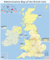
File:Map of the administrative geography of the United Kingdom.png

Rozmiar pierwotny (2806 × 4179 pikseli, rozmiar pliku: 1,06 MB, typ MIME: image/png)
Podpisy
Podpisy
| OpisMap of the administrative geography of the United Kingdom.png |
|
||
| Data | |||
| Źródło | Praca własna, using this diagram | ||
| Autor | Maximilian Dörrbecker (Chumwa) | ||
| Licencja (Ponowne użycie tego pliku) |
Ten plik udostępniony jest na licencji Creative Commons Uznanie autorstwa – Na tych samych warunkach 3.0.
|
||
| Inne wersje |
|
Historia pliku
Kliknij na odpowiedniej dacie/czasie, aby zobaczyć wersję pliku z tamtego okresu.
| Data/czas | Miniatura | Wymiary | Użytkownik | Opis | |
|---|---|---|---|---|---|
| aktualny | 15:32, 1 kwi 2023 |  | 2806 × 4179 (1,06 MB) | NordNordWest (dyskusja | edycje) | upd April 2023 |
| 21:34, 15 lis 2022 |  | 2806 × 4179 (1,07 MB) | NordNordWest (dyskusja | edycje) | update Buckinghamshire and Northamptonshire | |
| 18:38, 7 maj 2019 |  | 2806 × 4179 (1,77 MB) | Chumwa (dyskusja | edycje) | Aktualisierung: Änderungen in der Verwaltungsgliederung am 1.4.2019 | |
| 18:10, 3 mar 2019 |  | 2806 × 4179 (1,78 MB) | Chumwa (dyskusja | edycje) | falsche Anzahl an non-metropolitan ceremonial counties im Infokasten für England korrigiert | |
| 19:21, 8 paź 2015 |  | 2806 × 4179 (1,78 MB) | Chumwa (dyskusja | edycje) | falsche Datei erwischt... | |
| 19:19, 8 paź 2015 |  | 3703 × 4450 (2,29 MB) | Chumwa (dyskusja | edycje) | Aktualisierung: Am 1. April ist eine Verwaltungsreform in Nordirland in Kraft getreten. | |
| 17:43, 15 kwi 2013 |  | 2806 × 4179 (1,82 MB) | Chumwa (dyskusja | edycje) | Isle of Wight | |
| 21:50, 14 wrz 2011 |  | 2806 × 4179 (1,68 MB) | Chumwa (dyskusja | edycje) | corr | |
| 05:38, 27 maj 2010 |  | 2806 × 4179 (1,66 MB) | Chumwa (dyskusja | edycje) | civil parishes were replaced by communities in Wales in 1974 | |
| 21:42, 25 maj 2010 |  | 2806 × 4179 (1,66 MB) | Chumwa (dyskusja | edycje) | ein paar Verbesserungen... |
Nie możesz nadpisać tego pliku.
Lokalne wykorzystanie pliku
Następujące strony korzystają z tego pliku:
- Atlas of the United Kingdom
- Maps of the United Kingdom
- User:Chumwa/Gallery
- File:Map of the British postcode areas.png
- File:Map of the administrative geography of the British Isles.jpg
- File:Map of the administrative geography of the British Isles with postcode areas.jpg
- File:Map of the administrative geography of the United Kingdom.png
Globalne wykorzystanie pliku
Ten plik jest wykorzystywany także w innych projektach wiki:
- Wykorzystanie na ar.wikipedia.org
- Wykorzystanie na az.wikipedia.org
- Wykorzystanie na bar.wikipedia.org
- Wykorzystanie na be.wikipedia.org
- Wykorzystanie na bg.wikipedia.org
- Wykorzystanie na bs.wikipedia.org
- Wykorzystanie na de.wikipedia.org
- Wykorzystanie na en.wikipedia.org
- Talk:Bromley and Chislehurst (UK Parliament constituency)
- Talk:Lewisham Deptford (UK Parliament constituency)
- Administrative geography of the United Kingdom
- Talk:University constituency
- Talk:Rotten and pocket boroughs
- Talk:Foyle (UK Parliament constituency)
- Talk:Fermanagh and South Tyrone (UK Parliament constituency)
- Talk:Belfast South (UK Parliament constituency)
- Talk:Belfast North (UK Parliament constituency)
- Talk:Combined Scottish Universities (UK Parliament constituency)
- Talk:Tralee (UK Parliament constituency)
- Talk:Belfast West (UK Parliament constituency)
- Category talk:Constituencies of the Parliament of the United Kingdom
- Talk:List of United Kingdom Parliament constituencies (2005–2010)
- Talk:Aberavon (UK Parliament constituency)
- Talk:Hampstead and Highgate (UK Parliament constituency)
- Talk:Folkestone and Hythe (UK Parliament constituency)
- Template:WikiProject UK Parliament constituencies
- Category talk:Constituencies of the Parliament of the United Kingdom (historic)
- Talk:Armagh (UK Parliament constituency)
- Talk:Caithness and Sutherland (UK Parliament constituency)
- Talk:East Gloucestershire (UK Parliament constituency)
- Talk:Londonderry (UK Parliament constituency)
- Talk:Queen's University of Belfast (UK Parliament constituency)
- Talk:Roscommon (constituency)
- Talk:Beckenham (UK Parliament constituency)
- Talk:Bosworth (UK Parliament constituency)
- Talk:Blaydon (UK Parliament constituency)
- Talk:Braintree (UK Parliament constituency)
- Talk:Bethnal Green and Bow (UK Parliament constituency)
- Talk:Bridgwater (UK Parliament constituency)
- Talk:Brent East (UK Parliament constituency)
- Talk:Bromsgrove (UK Parliament constituency)
- Talk:Caithness, Sutherland and Easter Ross (UK Parliament constituency)
- Talk:Calder Valley (UK Parliament constituency)
- Talk:North West Cambridgeshire (UK Parliament constituency)
- Talk:Canterbury (UK Parliament constituency)
Pokaż listę globalnego wykorzystania tego pliku.
Metadane
Niniejszy plik zawiera dodatkowe informacje, prawdopodobnie dodane przez aparat cyfrowy lub skaner użyte do wygenerowania tego pliku.
Jeśli plik był modyfikowany, dane mogą być częściowo niezgodne z parametrami zmodyfikowanego pliku.
| Rozdzielczość w poziomie | 86,61 punktów na centymetr |
|---|---|
| Rozdzielczość w pionie | 86,61 punktów na centymetr |


