File:Map of the maritime parts of Virginia exhibiting the seat of war and of Ld. Dunmore's depredations in that colony. LOC gm71005446.jpg
Jump to navigation
Jump to search

Size of this preview: 706 × 600 pixels. Other resolutions: 283 × 240 pixels | 565 × 480 pixels | 904 × 768 pixels | 1,206 × 1,024 pixels | 2,411 × 2,048 pixels | 4,603 × 3,910 pixels.
Original file (4,603 × 3,910 pixels, file size: 2.64 MB, MIME type: image/jpeg)
Captions
Captions
Add a one-line explanation of what this file represents
Summary
[edit]| Description |
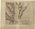
English: Scale ca. 1:700,000. Hand colored. "For the Pennsa. Mag. p. 184." LC Maps of North America, 1750-1789, 1442 Available also through the Library of Congress Web site as a raster image. Vault AACR2 |
||
| Title | Map of the maritime parts of Virginia exhibiting the seat of war and of Ld. Dunmore's depredations in that colony. | ||
| Shelf ID | G3880 1776 .D8 | ||
| Date | |||
| Source | https://www.loc.gov/item/gm71005446/ | ||
| Author | Du Simitière, Pierre Eugène; Aitken, Robert | ||
| Permission (Reusing this file) |
|
||
| Other versions |
|
||
| Location | United States · Chesapeake Bay · Maryland · Virginia | ||
| Part of | Military Battles And Campaigns · American Memory · Catalog · Geography And Map Division · American Revolution And Its Era: Maps And Charts Of North America And The West Indies, 1750-1789 | ||
| Subject | Chesapeake Bay · Virginia · United States · Maps · Early Works To 1800 · Maryland · Chesapeake Bay (Md. And Va.) |

Licensing
[edit]
|
This is a faithful photographic reproduction of a two-dimensional, public domain work of art. The work of art itself is in the public domain for the following reason:
The official position taken by the Wikimedia Foundation is that "faithful reproductions of two-dimensional public domain works of art are public domain".
This photographic reproduction is therefore also considered to be in the public domain in the United States. In other jurisdictions, re-use of this content may be restricted; see Reuse of PD-Art photographs for details. | ||||
File history
Click on a date/time to view the file as it appeared at that time.
| Date/Time | Thumbnail | Dimensions | User | Comment | |
|---|---|---|---|---|---|
| current | 07:38, 21 May 2018 | | 4,603 × 3,910 (2.64 MB) | Fæ (talk | contribs) | LOC Maps https://www.loc.gov/item/gm71005446/ #12735 |
You cannot overwrite this file.
File usage on Commons
The following page uses this file: