File:Map of the route of Edward III's chevauchée of 1346.svg
Aller à la navigation
Aller à la recherche

Taille de cet aperçu PNG pour ce fichier SVG : 643 × 600 pixels. Autres résolutions : 257 × 240 pixels | 515 × 480 pixels | 823 × 768 pixels | 1 098 × 1 024 pixels | 2 195 × 2 048 pixels | 1 059 × 988 pixels.
Fichier d’origine (Fichier SVG, nominalement de 1 059 × 988 pixels, taille : 450 kio)
Légendes
Légendes
Ajoutez en une ligne la description de ce que représente ce fichier
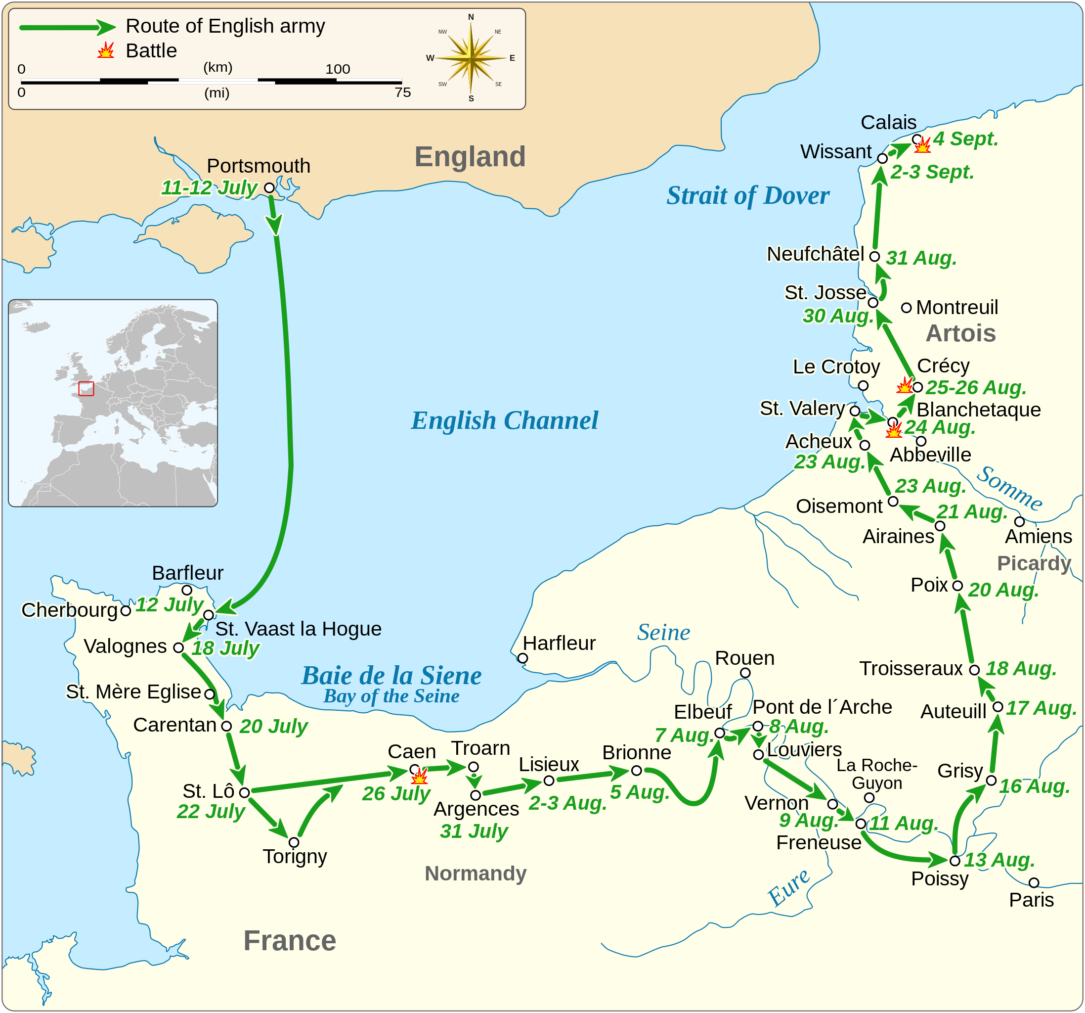
Map of the route of Edward III's chevauchée of 1346, part of the Hundred Years' War
Description[modifier]
| Description |
English: Map of the route of Edward III's chevauchée of 1346, part of the Hundred Years' War. This map shows the English army movements during the campaign and the most important battles.
|
||||||||||||||||||||||||||||||||||||||||||||||||||||||||||
| Date | |||||||||||||||||||||||||||||||||||||||||||||||||||||||||||
| Source |
Travail personnel Derived from; Information from:
|
||||||||||||||||||||||||||||||||||||||||||||||||||||||||||
| Auteur | Goran tek-en | ||||||||||||||||||||||||||||||||||||||||||||||||||||||||||
| Autorisation (Réutilisation de ce fichier) |
Ce fichier est sous la licence Creative Commons Attribution – Partage dans les Mêmes Conditions 4.0 International. Attribution: Goran tek-en
|
||||||||||||||||||||||||||||||||||||||||||||||||||||||||||
| SVG information | Cette image vectorielle a été créée avec Inkscape. |
||||||||||||||||||||||||||||||||||||||||||||||||||||||||||


| Position de l'objet | | Voir cet endroit et d’autres images sur : OpenStreetMap |
|---|


Historique du fichier
Cliquer sur une date et heure pour voir le fichier tel qu'il était à ce moment-là.
| Date et heure | Vignette | Dimensions | Utilisateur | Commentaire | |
|---|---|---|---|---|---|
| actuel | 3 février 2022 à 00:14 | | 1 059 × 988 (450 kio) | Iso10970 (d | contributions) | Reverted to version as of 13:17, 9 November 2021 (UTC) |
| 3 février 2022 à 00:13 |  | 1 059 × 988 (614 kio) | Iso10970 (d | contributions) | File uploaded using svgtranslate tool (https://svgtranslate.toolforge.org/). Added translation for ja. | |
| 9 novembre 2021 à 13:17 |  | 1 059 × 988 (450 kio) | Goran tek-en (d | contributions) | Changed view box, font size, added location map | |
| 14 avril 2019 à 13:06 |  | 1 059 × 988 (191 kio) | Goran tek-en (d | contributions) | Spelling | |
| 10 mars 2019 à 17:53 |  | 1 059 × 988 (115 kio) | JoKalliauer (d | contributions) | phab:T36947 bad character aligment on same sizes | |
| 6 mars 2019 à 14:08 |  | 1 059 × 988 (191 kio) | Goran tek-en (d | contributions) | {{Information |description ={{en|1=Map of the route of Edward III's chevauchée of 1346, part of the Hundred Years' War. This map shows the English army movements during the campaign and the most important battles.}} |date =20190306 |source ={{Own}}<br> Derived from; * [https://www.openstreetmap.org/#map=8/49.919/1.371 OSM] Information from: * [https://www.themaparchive.com/the-crecy-campaign-12-july-to-4-september-1346.html themaparchive.com] * {{U|Newm30}} |author... |
Vous ne pouvez pas remplacer ce fichier.
Utilisations locales du fichier
Les 8 pages suivantes utilisent ce fichier :
- User:Goran tek-en/Gallery/2019
- User:Magog the Ogre/Maps of conflicts/2019 April
- User:Magog the Ogre/Maps of conflicts/2019 March
- User:Magog the Ogre/Maps of conflicts/2021 November
- User:Magog the Ogre/Maps of conflicts/2022 February
- File:Map of Gascon campaign of 1345.svg
- File:Map of route of Black Prince chevauchée of 1355.svg
- File:Map of route of Lancaster's chevauchée of 1346.svg
Utilisations du fichier sur d’autres wikis
Les autres wikis suivants utilisent ce fichier :
- Utilisation sur cs.wikipedia.org
- Utilisation sur en.wikipedia.org
- Utilisation sur es.wikipedia.org
- Utilisation sur fi.wikipedia.org
- Utilisation sur fr.wikipedia.org
- Utilisation sur hu.wikipedia.org
- Utilisation sur ja.wikipedia.org
- Utilisation sur nl.wikipedia.org
- Utilisation sur pt.wikipedia.org
- Utilisation sur ru.wikipedia.org
- Utilisation sur sh.wikipedia.org
- Utilisation sur tr.wikipedia.org
- Utilisation sur zh.wikipedia.org