File:Map of the route of Edward III's chevauchée of 1346.svg
ナビゲーションに移動
検索に移動

この SVG ファイルのこの PNG プレビューのサイズ: 643 × 600 ピクセル. その他の解像度: 257 × 240 ピクセル | 515 × 480 ピクセル | 823 × 768 ピクセル | 1,098 × 1,024 ピクセル | 2,195 × 2,048 ピクセル | 1,059 × 988 ピクセル。
元のファイル (SVG ファイル、1,059 × 988 ピクセル、ファイルサイズ: 450キロバイト)
キャプション
キャプション
このファイルの内容を1行で記述してください
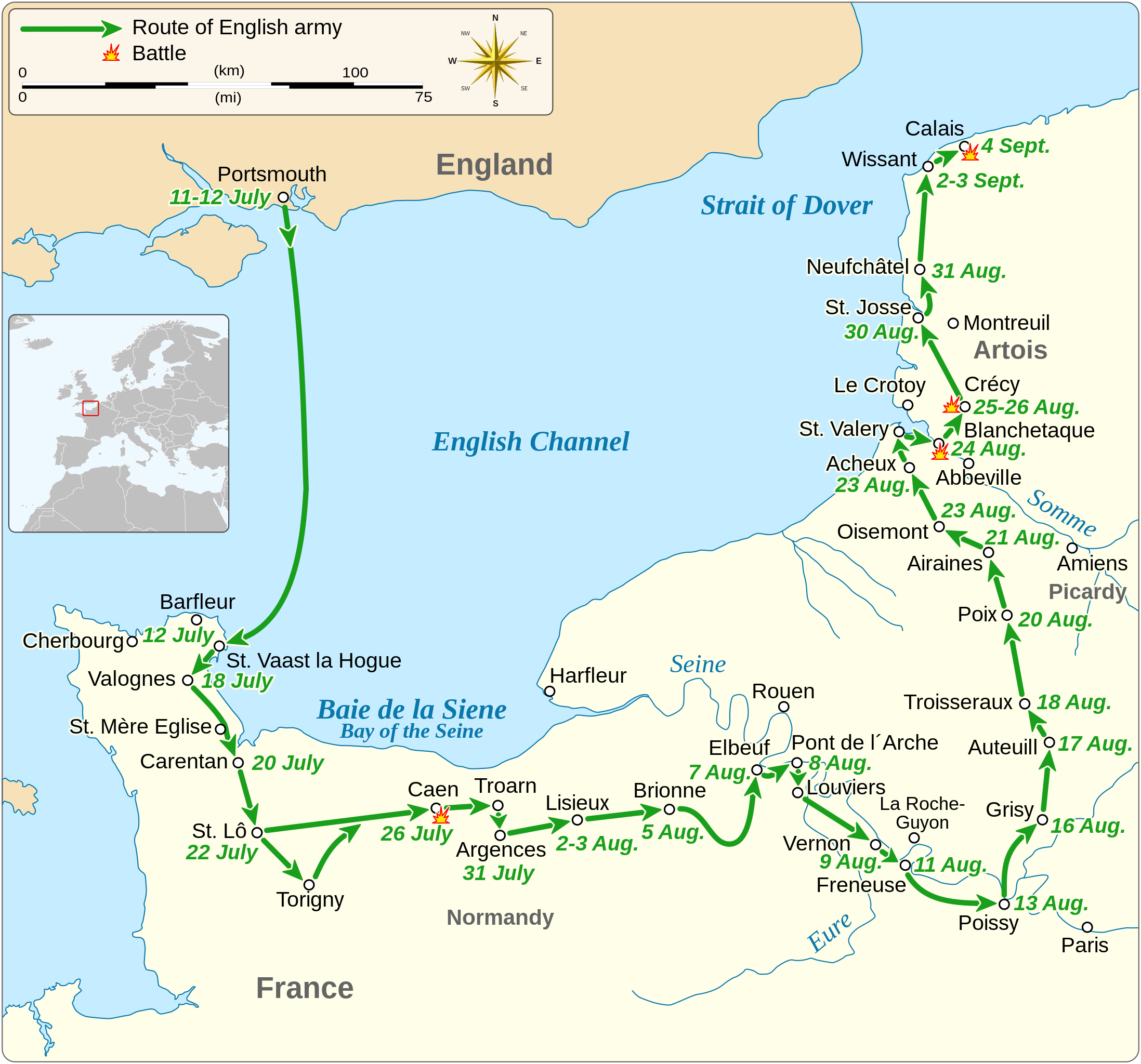
Map of the route of Edward III's chevauchée of 1346, part of the Hundred Years' War
概要
[編集]| 解説 |
English: Map of the route of Edward III's chevauchée of 1346, part of the Hundred Years' War. This map shows the English army movements during the campaign and the most important battles.
|
|||
| 日付 | ||||
| 原典 |
投稿者自身による著作物 Derived from; Information from:
|
|||
| 作者 | Goran tek-en | |||
| 許可 (ファイルの再利用) |
このファイルはクリエイティブ・コモンズ 表示-継承 4.0 国際ライセンスのもとに利用を許諾されています。 帰属: Goran tek-en
|
|||
| SVG 開発 |


| 被写体の位置 | | 以下のサービスでこの位置を確認する: オープンストリートマップ |
|---|


ファイルの履歴
過去の版のファイルを表示するには、その版の日時をクリックしてください。
| 日付と時刻 | サムネイル | 寸法 | 利用者 | コメント | |
|---|---|---|---|---|---|
| 現在の版 | 2022年2月3日 (木) 00:14 | | 1,059 × 988 (450キロバイト) | Iso10970 (トーク | 投稿記録) | Reverted to version as of 13:17, 9 November 2021 (UTC) |
| 2022年2月3日 (木) 00:13 |  | 1,059 × 988 (614キロバイト) | Iso10970 (トーク | 投稿記録) | File uploaded using svgtranslate tool (https://svgtranslate.toolforge.org/). Added translation for ja. | |
| 2021年11月9日 (火) 13:17 |  | 1,059 × 988 (450キロバイト) | Goran tek-en (トーク | 投稿記録) | Changed view box, font size, added location map | |
| 2019年4月14日 (日) 13:06 |  | 1,059 × 988 (191キロバイト) | Goran tek-en (トーク | 投稿記録) | Spelling | |
| 2019年3月10日 (日) 17:53 |  | 1,059 × 988 (115キロバイト) | JoKalliauer (トーク | 投稿記録) | phab:T36947 bad character aligment on same sizes | |
| 2019年3月6日 (水) 14:08 |  | 1,059 × 988 (191キロバイト) | Goran tek-en (トーク | 投稿記録) | {{Information |description ={{en|1=Map of the route of Edward III's chevauchée of 1346, part of the Hundred Years' War. This map shows the English army movements during the campaign and the most important battles.}} |date =20190306 |source ={{Own}}<br> Derived from; * [https://www.openstreetmap.org/#map=8/49.919/1.371 OSM] Information from: * [https://www.themaparchive.com/the-crecy-campaign-12-july-to-4-september-1346.html themaparchive.com] * {{U|Newm30}} |author... |
このファイルは上書きできません。
ファイルの使用状況
以下の 8 ページがこのファイルを使用しています:
- User:Goran tek-en/Gallery/2019
- User:Magog the Ogre/Maps of conflicts/2019 April
- User:Magog the Ogre/Maps of conflicts/2019 March
- User:Magog the Ogre/Maps of conflicts/2021 November
- User:Magog the Ogre/Maps of conflicts/2022 February
- File:Map of Gascon campaign of 1345.svg
- File:Map of route of Black Prince chevauchée of 1355.svg
- File:Map of route of Lancaster's chevauchée of 1346.svg
グローバルなファイル使用状況
以下に挙げる他のウィキがこの画像を使っています:
- cs.wikipedia.org での使用状況
- en.wikipedia.org での使用状況
- es.wikipedia.org での使用状況
- fi.wikipedia.org での使用状況
- fr.wikipedia.org での使用状況
- hu.wikipedia.org での使用状況
- ja.wikipedia.org での使用状況
- nl.wikipedia.org での使用状況
- pt.wikipedia.org での使用状況
- ru.wikipedia.org での使用状況
- sh.wikipedia.org での使用状況
- tr.wikipedia.org での使用状況
- zh.wikipedia.org での使用状況