File:Map of the seat of war showing the battles of July 18th, 21st & Oct. 21st 1861. LOC lva0000218.jpg
Jump to navigation
Jump to search

Size of this preview: 546 × 600 pixels. Other resolutions: 218 × 240 pixels | 437 × 480 pixels | 699 × 768 pixels | 932 × 1,024 pixels | 1,865 × 2,048 pixels | 7,838 × 8,609 pixels.
Original file (7,838 × 8,609 pixels, file size: 8.72 MB, MIME type: image/jpeg)
Captions
Captions
Add a one-line explanation of what this file represents
Summary[edit]
| Description |
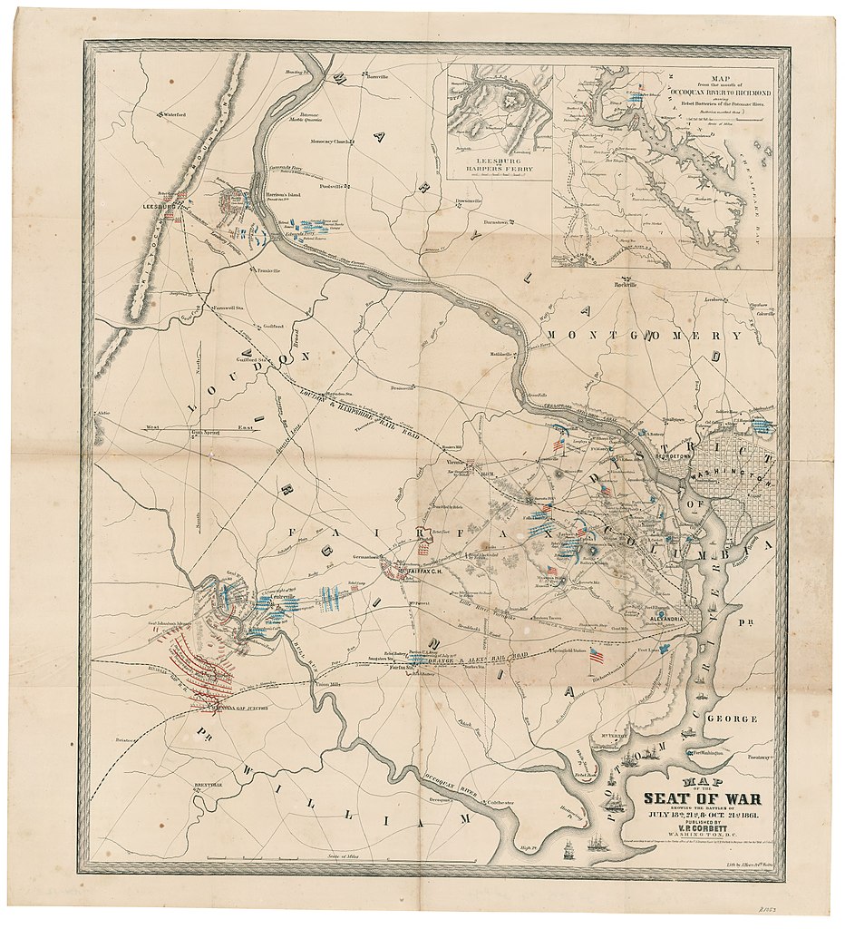
English: Similar to no. 564, LC Civil War maps (2nd ed.). Map of the battles of first Manassas and Ball's Bluff, showing troop camps, entrenchments, forts, batteries, positions during engagements, roads, railroads, street pattern of Washington and Alexandria, towns, drainage, vegetation, and some indication of relief by hachures. Depths shown by isolines. Annotated in red and blue to show Union and Confederate positions. With hand colored American flags. Insets: Leesburg to Harpers Ferry. Scale ca. 1:400,000. 9 x 9 cm. -- Map from the mouth of Occoquan River to Richmond showing rebel batteries on the Potomac River. Scale ca. 1:810,000. 16 x 18 cm. Description derived from published bibliography. "Entered according to act of Congress in the Clerks office of the U.S. District Court by V.P. Corbett in the year 1861 for the Dist. of Columb." Available also through the Library of Congress web site as raster image. |
||
| Title | Map of the seat of war showing the battles of July 18th, 21st & Oct. 21st 1861. | ||
| Shelf ID | https://www.loc.gov/item/lva0000218/ | ||
| Date | |||
| Source | https://www.loc.gov/item/lva0000218/ | ||
| Author | Corbett, V. P.; A. Hoen & Co. | ||
| Permission (Reusing this file) |
|
||
| Other versions |
|
||
| Location | United States · Manassas Region · Leesburg Region · Virginia | ||
| Part of | American Memory | ||
| Subject | Ball'S Bluff, Battle Of, Va. · Bull Run, 1St Battle Of, Va. · Virginia · United States · Maps · Manassas Region · Leesburg Region |


Licensing[edit]
|
This is a faithful photographic reproduction of a two-dimensional, public domain work of art. The work of art itself is in the public domain for the following reason:
The official position taken by the Wikimedia Foundation is that "faithful reproductions of two-dimensional public domain works of art are public domain".
This photographic reproduction is therefore also considered to be in the public domain in the United States. In other jurisdictions, re-use of this content may be restricted; see Reuse of PD-Art photographs for details. | ||||
File history
Click on a date/time to view the file as it appeared at that time.
| Date/Time | Thumbnail | Dimensions | User | Comment | |
|---|---|---|---|---|---|
| current | 07:12, 18 May 2018 | | 7,838 × 8,609 (8.72 MB) | Fæ (talk | contribs) | LOC Maps https://www.loc.gov/item/lva0000218/ #10618 |
You cannot overwrite this file.
File usage on Commons
The following page uses this file: