File:Map provinces Netherlands-nl.svg
跳转到导航
跳转到搜索

此SVG文件的PNG预览的大小:506 × 600像素。 其他分辨率:202 × 240像素 | 405 × 480像素 | 648 × 768像素 | 864 × 1,024像素 | 1,727 × 2,048像素 | 743 × 881像素。
原始文件 (SVG文件,尺寸为743 × 881像素,文件大小:856 KB)
说明
说明
添加一行文字以描述该文件所表现的内容

|
此SVG檔案包含可翻譯至您的語言的内嵌文字,可以使用任何可用SVG編輯器、文本編輯器或SVG翻譯工具來翻譯。詳情請見:關於翻譯SVG檔案。 |
摘要[编辑]
| 描述 |
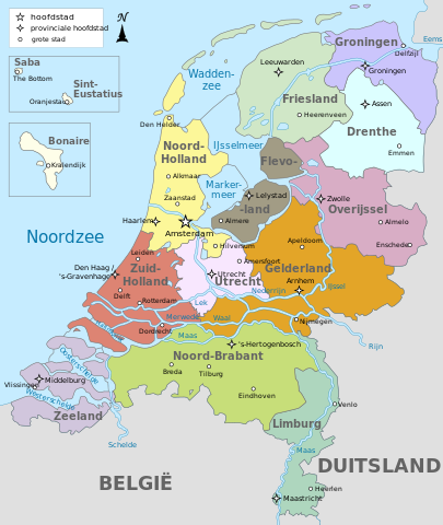
Français : Carte des provinces de Pays-Bas en néerlandais
English: Map of the provinces of the Netherlands in Dutch |
| 日期 | |
| 来源 | 自己的作品. Translated from File:Map provinces Netherlands-de.svg, using this map for the Dutch names |
| 作者 | Alphathon (original German SVG); Bibi Saint-Pol (SVG translation) |
| 其他版本 |
[]
|


.svg)
许可协议[编辑]
我,本作品著作权人,特此采用以下许可协议发表本作品:
本文件采用知识共享署名-相同方式共享 3.0 未本地化版本许可协议授权。
- 您可以自由地:
- 共享 – 复制、发行并传播本作品
- 修改 – 改编作品
- 惟须遵守下列条件:
- 署名 – 您必须对作品进行署名,提供授权条款的链接,并说明是否对原始内容进行了更改。您可以用任何合理的方式来署名,但不得以任何方式表明许可人认可您或您的使用。
- 相同方式共享 – 如果您再混合、转换或者基于本作品进行创作,您必须以与原先许可协议相同或相兼容的许可协议分发您贡献的作品。

|
已授权您依据自由软件基金会发行的无固定段落及封面封底文字(Invariant Sections, Front-Cover Texts, and Back-Cover Texts)的GNU自由文件许可协议1.2版或任意后续版本的条款,复制、传播和/或修改本文件。该协议的副本请见“GNU Free Documentation License”。 |
您可以选择您需要的许可协议。
文件历史
点击某个日期/时间查看对应时刻的文件。
| 日期/时间 | 缩略图 | 大小 | 用户 | 备注 | |
|---|---|---|---|---|---|
| 当前 | 2023年4月18日 (二) 22:43 | | 743 × 881(856 KB) | Von Freudstein-Reinach(留言 | 贡献) | File uploaded using svgtranslate tool (https://svgtranslate.toolforge.org/). Added translation for oc. |
| 2019年2月17日 (日) 11:43 |  | 743 × 881(809 KB) | Thayts(留言 | 贡献) | Fixed Eastern Scheldt which wasn't rendered by the MediaWiki engine; removed Belgian city of Antwerp | |
| 2019年2月16日 (六) 13:29 |  | 743 × 881(809 KB) | Thayts(留言 | 贡献) | Updated borders | |
| 2014年10月15日 (三) 08:53 |  | 743 × 881(887 KB) | Bibi Saint-Pol(留言 | 贡献) | User created page with UploadWizard |
您不可以覆盖此文件。
文件用途
以下17个页面使用本文件:
- Atlas of the Netherlands
- User:Magog the Ogre/Multilingual legend/2023 April 11-20
- File:Map provinces Netherlands-de.svg
- File:Map provinces Netherlands-el.svg
- File:Map provinces Netherlands-en.svg
- File:Map provinces Netherlands-es.svg
- File:Map provinces Netherlands-fr.svg
- File:Map provinces Netherlands-fy.svg
- File:Map provinces Netherlands-he.svg
- File:Map provinces Netherlands-it.svg
- File:Map provinces Netherlands-ja.svg
- File:Map provinces Netherlands-mk.svg
- File:Map provinces Netherlands-nl.svg
- File:Netherlands Map (Without Islands).svg
- File:Netherlands map large dutch-10-10-10.png
- File:Netherlands map large dutch 3.png
- Template:Other versions/Map provinces Netherlands
全域文件用途
以下其他wiki使用此文件:
- ar.wikipedia.org上的用途
- ban.wikipedia.org上的用途
- da.wikipedia.org上的用途
- en.wikipedia.org上的用途
- id.wikipedia.org上的用途
- ku.wikipedia.org上的用途
- li.wikipedia.org上的用途
- lld.wikipedia.org上的用途
- nds-nl.wikipedia.org上的用途
- nl.wikipedia.org上的用途
- uz.wikipedia.org上的用途
- vls.wikipedia.org上的用途
- vo.wikipedia.org上的用途
- zea.wikipedia.org上的用途
- zh.wikipedia.org上的用途