File:Map shewing the site of Melbourne and the position of the huts and buildings previous to the foundation of the township by Sir Richard Bourke -- Robert Russell - KONB16-414778251 - Prent 1 van 1.jpg

Original file (1,500 × 1,129 pixels, file size: 190 KB, MIME type: image/jpeg)
Captions
Captions
Summary
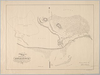
[edit]| Map shewing the site of Melbourne and the position of the huts and buildings previous to the foundation of the township by Sir Richard Bourke -- Robert Russell
( |
|||||||||||||||||||||
|---|---|---|---|---|---|---|---|---|---|---|---|---|---|---|---|---|---|---|---|---|---|
| Artist |
Creator(s) and/or contributor(s) of this object:
|
||||||||||||||||||||
| Title |
Map shewing the site of Melbourne and the position of the huts and buildings previous to the foundation of the township by Sir Richard Bourke -- Robert Russell |
||||||||||||||||||||
| Object type | map | ||||||||||||||||||||
| Description |
Scale 8 inches to a mile |
||||||||||||||||||||
| Date | circa 1840 | ||||||||||||||||||||
| Collection |
|
||||||||||||||||||||
| Accession number |
|
||||||||||||||||||||
| Source/Photographer |
Source page of image: http://resolver.kb.nl/resolve?urn=urn:gvn:KONB16:414778251
|
||||||||||||||||||||

Licensing
[edit]
|
This is a faithful photographic reproduction of a two-dimensional, public domain work of art. The work of art itself is in the public domain for the following reason:
The official position taken by the Wikimedia Foundation is that "faithful reproductions of two-dimensional public domain works of art are public domain".
This photographic reproduction is therefore also considered to be in the public domain in the United States. In other jurisdictions, re-use of this content may be restricted; see Reuse of PD-Art photographs for details. | ||||
File history
Click on a date/time to view the file as it appeared at that time.
| Date/Time | Thumbnail | Dimensions | User | Comment | |
|---|---|---|---|---|---|
| current | 12:50, 5 October 2022 | | 1,500 × 1,129 (190 KB) | OlafJanssen (talk | contribs) | Creating new file "File:Map shewing the site of Melbourne and the position of the huts and buildings previous to the foundation of the township by Sir Richard Bourke -- Robert Russell - KONB16:414778251 - Prent 1 van 1.jpg" via API upload with custom Python script |
You cannot overwrite this file.
File usage on Commons
The following page uses this file: