File:Map showing properties under jurisdiction of the Architect of the Capitol - (Capitol Hill, Washington, D.C.) LOC 93680157.jpg
Jump to navigation
Jump to search

Size of this preview: 796 × 600 pixels. Other resolutions: 319 × 240 pixels | 637 × 480 pixels | 1,020 × 768 pixels | 1,280 × 964 pixels | 2,560 × 1,928 pixels | 7,284 × 5,486 pixels.
Original file (7,284 × 5,486 pixels, file size: 5.84 MB, MIME type: image/jpeg)
Captions
Captions
Add a one-line explanation of what this file represents
Summary
[edit]| Description |
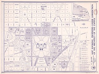
English: Also shows government buildings and block numbers. Oriented with north to the left. Blue-line print. Includes notes and inset of "U.S. Botanic Gardens nursery at D.C. Village." Available also through the Library of Congress Web site as a raster image. DCP |
||
| Title | Map showing properties under jurisdiction of the Architect of the Capitol : [Capitol Hill, Washington, D.C.] | ||
| Shelf ID | G3852.U518 1992 .U5 | ||
| Date | |||
| Source | https://www.loc.gov/item/93680157/ | ||
| Author | United States. Architect Of The Capitol; White, George M. (George Malcolm) | ||
| Permission (Reusing this file) |
|
||
| Other versions |
|
||
| Location | Washington D.C. · United States Capitol · Capitol Hill · Washington · United States · District Of Columbia | ||
| Part of | American Memory · Cities And Towns · Catalog · Geography And Map Division | ||
| Subject | Washington (D.C.) · United States Capitol · Public Lands · Capitol Hill (Washington, D.C.) · Capitol Hill · Washington · United States Capitol (Washington, D.C.) · United States · Maps · District Of Columbia · Public Buildings |


_LOC_93680157.jpg&action=edit§ion=1)
Licensing
[edit]_LOC_93680157.jpg&action=edit§ion=2)
This work is in the public domain in the United States because it is a work prepared by an officer or employee of the United States Government as part of that person’s official duties under the terms of Title 17, Chapter 1, Section 105 of the US Code.
Note: This only applies to original works of the Federal Government and not to the work of any individual U.S. state, territory, commonwealth, county, municipality, or any other subdivision. This template also does not apply to postage stamp designs published by the United States Postal Service since 1978. (See § 313.6(C)(1) of Compendium of U.S. Copyright Office Practices). It also does not apply to certain US coins; see The US Mint Terms of Use.
|
 | |
| This file has been identified as being free of known restrictions under copyright law, including all related and neighboring rights. | ||
File history
Click on a date/time to view the file as it appeared at that time.
| Date/Time | Thumbnail | Dimensions | User | Comment | |
|---|---|---|---|---|---|
| current | 09:02, 13 June 2018 | | 7,284 × 5,486 (5.84 MB) | Fæ (talk | contribs) | LOC Maps https://www.loc.gov/item/93680157/ #13948 |
You cannot overwrite this file.
File usage on Commons
The following page uses this file:
_LOC_93680157.jpg&oldid=737079589)