File:Mapa Podarcis Iberia.svg
Ir a la navegación
Ir a la búsqueda

Tamaño de esta previsualización PNG del archivo SVG: 520 × 573 píxeles. Otras resoluciones: 218 × 240 píxeles | 436 × 480 píxeles | 697 × 768 píxeles | 929 × 1024 píxeles | 1859 × 2048 píxeles.
Archivo original (archivo SVG, nominalmente 520 × 573 píxeles, tamaño de archivo: 144 kB)
Leyendas
Leyendas
Añade una explicación corta acerca de lo que representa este archivo
Resumen[editar]
| Descripción |
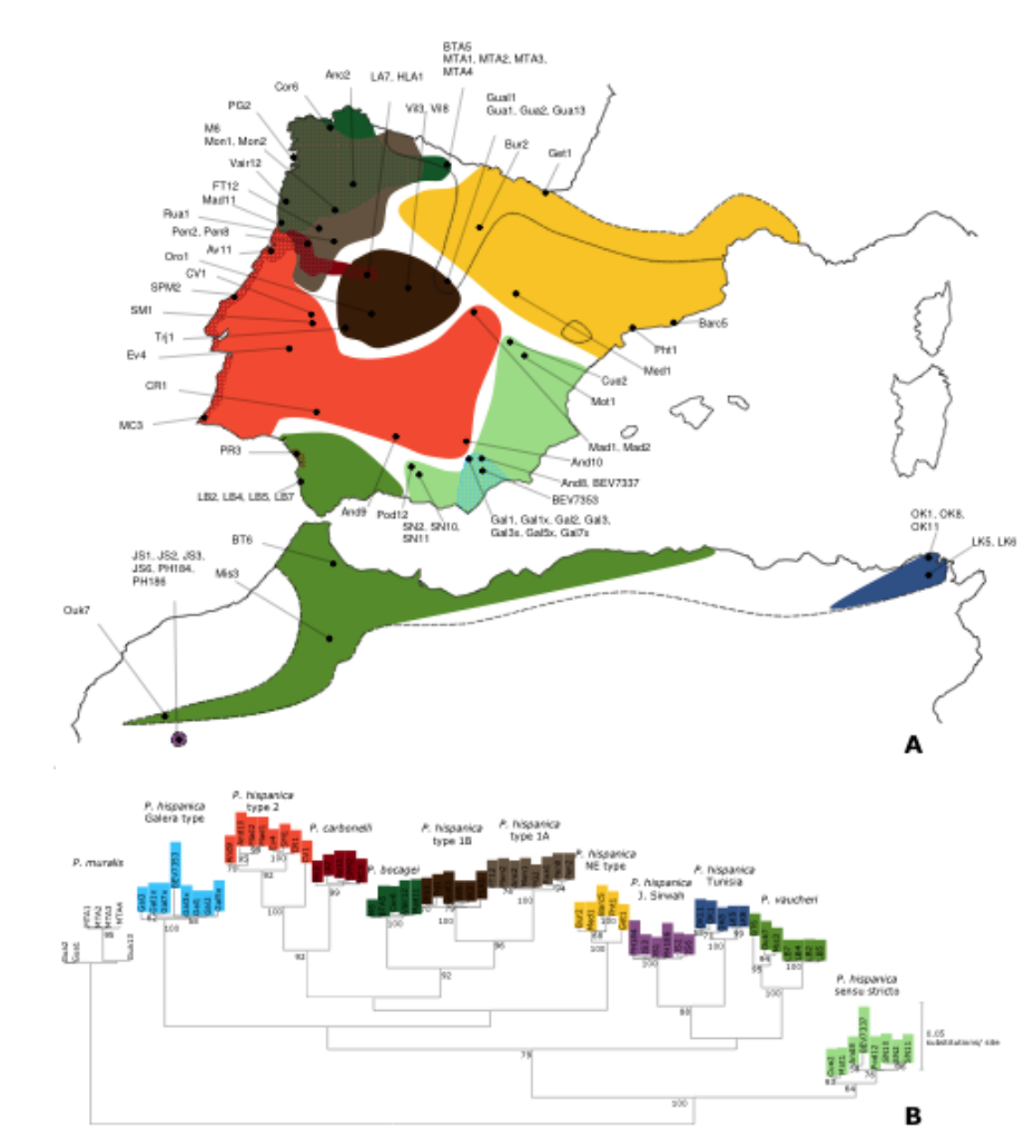
English: Distribution map of Podarcis lizards in the Iberian Peninsula and North Africa. Original figure legend: Geographical origin and mitochondrial DNA assignment of samples used in this study. A. Map of the Iberian Peninsula and the Maghreb showing the putative distribution of mtDNA lineages based on a compilation of available data and samples analysed in this study. The dashed line represents the distribution of the Iberian-Maghrebian clade of Podarcis; the dotted line represents the limits of the Iberian distribution of P. muralis. B. Maximum-likelihood tree of the mitochondrial gene ND4 for the samples analysed. Bootstrap values over 50% are shown.
Figure published in BMC Evolutionary Biology, under their Open Access feature. Open Access article distributed under the terms of the Creative Commons Attribution License (https://creativecommons.org/licenses/by/2.0).
Português: Mapa de distribuição de lagartos do género Podarcis na Península Ibérica e Norte de África |
| Fecha | |
| Fuente | Non-equilibrium estimates of gene flow inferred from nuclear genealogies suggest that Iberian and North African wall lizards (Podarcis spp.) are an assemblage of incipient species BMC Evolutionary Biology Accepted: 26 February 2008 http://www.biomedcentral.com/1471-2148/8/63 |
| Autor | Catarina Pinho, D James Harris and Nuno Ferrand |
| Permiso (Reutilización de este archivo) |
Este archivo se encuentra bajo la licencia Creative Commons Genérica de Atribución/Compartir-Igual 3.0.
|
| Otras versiones | File:Mapa Podarcis Iberia.tiff |
| SVG desarrollo | El código fuente de esta imagen SVG es válido. |

Registro original de carga[editar]
This image is a derivative work of the following images:
- File:Mapa Podarcis Iberia.tiff licensed with Cc-by-3.0
- 2009-04-13T15:39Z GoEThe 520 × 573 pixels (1.14 MB) {{Information |Description={{en|1=Distribution map of ''Podarcis'' lizards in the Iberian Peninsula and North Africa. '''Original figure legend''': Geographical origin and mitochondrial DNA assignment of samples used in this study. A. Map of the Iberian P)
Historial del archivo
Haz clic sobre una fecha y hora para ver el archivo tal como apareció en ese momento.
| Fecha y hora | Miniatura | Dimensiones | Usuario | Comentario | |
|---|---|---|---|---|---|
| actual | 18:40 6 sep 2009 | | 520 × 573 (144 kB) | Rrburke (discusión | contribs.) | Images not embedded in previous version |
| 18:32 6 sep 2009 |  | 520 × 573 (479 bytes) | Rrburke (discusión | contribs.) | {{Information |Description={{en|1={{en|1=Distribution map of ''Podarcis'' lizards in the Iberian Peninsula and North Africa. '''Original figure legend''': Geographical origin and mitochondrial DNA assignment of samples used in this study. A. Map of the Ib |
No puedes sobrescribir este archivo.
Usos del archivo
La siguiente página usa este archivo:
Uso global del archivo
Las wikis siguientes utilizan este archivo:
- Uso en arz.wikipedia.org
- Uso en bg.wikipedia.org
- Uso en ca.wikipedia.org
- Uso en ceb.wikipedia.org
- Uso en en.wikipedia.org
- Uso en es.wikipedia.org
- Uso en eu.wikipedia.org
- Uso en fa.wikipedia.org
- Uso en fi.wikipedia.org
- Uso en gl.wikipedia.org
- Uso en hu.wikipedia.org
- Uso en pt.wikipedia.org
- Uso en sv.wikipedia.org
- Uso en vi.wikipedia.org
- Uso en www.wikidata.org
- Uso en zh.wikipedia.org