File:Mapa Proyecto Arica Zapiga 1929.jpg
Jump to navigation
Jump to search

Size of this preview: 800 × 516 pixels. Other resolutions: 320 × 206 pixels | 640 × 413 pixels | 902 × 582 pixels.
Original file (902 × 582 pixels, file size: 76 KB, MIME type: image/jpeg)
Captions
Captions
Add a one-line explanation of what this file represents
Summary[edit]
| Description |
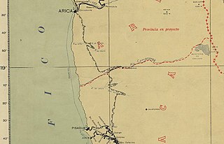
Español: Mapa que presenta el proyecto de ferrocarril Arica-Zapiga en 1929. |
| Date | |
| Source | Mapa de los ferrocarriles de Chile |
| Author | Taller de Fotolitografía del Servicio de Mensura y Clasificación de Tierras |
Licensing[edit]
This file has fallen into the public domain according to Chilean copyright law (No. 17336 and its amendments). Nevertheless, its author and source must be acknowledged.
See here for the type of material that is in the public domain (patrimonio cultural común / common cultural heritage).
|

|
File history
Click on a date/time to view the file as it appeared at that time.
| Date/Time | Thumbnail | Dimensions | User | Comment | |
|---|---|---|---|---|---|
| current | 17:21, 21 April 2020 | | 902 × 582 (76 KB) | Sfs90 (talk | contribs) | Uploaded a work by Taller de Fotolitografía del Servicio de Mensura y Clasificación de Tierras from [http://www.bibliotecanacionaldigital.gob.cl/bnd/631/w3-article-156653.html Mapa de los ferrocarriles de Chile] with UploadWizard |
You cannot overwrite this file.
File usage on Commons
The following 2 pages use this file:
File usage on other wikis
The following other wikis use this file:
- Usage on es.wikipedia.org