File:Mapa de los ferrocarriles de Chile - Ferrocarril Santiago Valparaiso (1929).jpg
Jump to navigation
Jump to search

Size of this preview: 800 × 440 pixels. Other resolutions: 320 × 176 pixels | 640 × 352 pixels | 1,024 × 563 pixels | 1,280 × 704 pixels | 2,007 × 1,104 pixels.
Original file (2,007 × 1,104 pixels, file size: 340 KB, MIME type: image/jpeg)
Captions
Captions
Add a one-line explanation of what this file represents
Summary[edit]
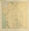
| Description |
Español: Mapa de los ferrocarriles en Chile al año 1929 y proyectados, entre los paralelos 16 y 43 sur. |
| Date | |
| Source | http://www.bibliotecanacionaldigital.gob.cl/bnd/631/w3-article-156653.html |
| Author | Talleres de Fotolitografía del Servicio de Mensura y Clasificación de Tierras |
| Other versions |
.jpg&action=edit§ion=1)
Mapa de los ferrocarriles de Chile [material cartográfico] Santiago: Talleres de Fotolitografía del Servicio de Mensura y Clasificación de Tierras, 1929. 1 atlas (6 hojas) : color ; 58 x 56 cm. Reproducción electrónica. Santiago, Chile : Biblioteca Nacional de Chile, Laboratorio Digital, 2014.
Licensing[edit]
.jpg&action=edit§ion=2)
This file has fallen into the public domain according to Chilean copyright law (No. 17336 and its amendments). Nevertheless, its author and source must be acknowledged.
See here for the type of material that is in the public domain (patrimonio cultural común / common cultural heritage).
|

|
File history
Click on a date/time to view the file as it appeared at that time.
| Date/Time | Thumbnail | Dimensions | User | Comment | |
|---|---|---|---|---|---|
| current | 01:59, 27 October 2021 | | 2,007 × 1,104 (340 KB) | LuisCG11 (talk | contribs) | File:Mapa de los ferrocarriles de Chile (1929).pdf cropped 71 % horizontally, 85 % vertically using CropTool with precise mode. |
You cannot overwrite this file.
File usage on Commons
The following 3 pages use this file:
File usage on other wikis
The following other wikis use this file:
- Usage on es.wikipedia.org
.jpg&oldid=605913938)