File:Mapa terremoto de Indonesia de 2012.png
Jump to navigation
Jump to search
No higher resolution available.
Mapa_terremoto_de_Indonesia_de_2012.png (540 × 558 pixels, file size: 92 KB, MIME type: image/png)
Captions
Captions
Add a one-line explanation of what this file represents
Summary
[edit]
| Description |
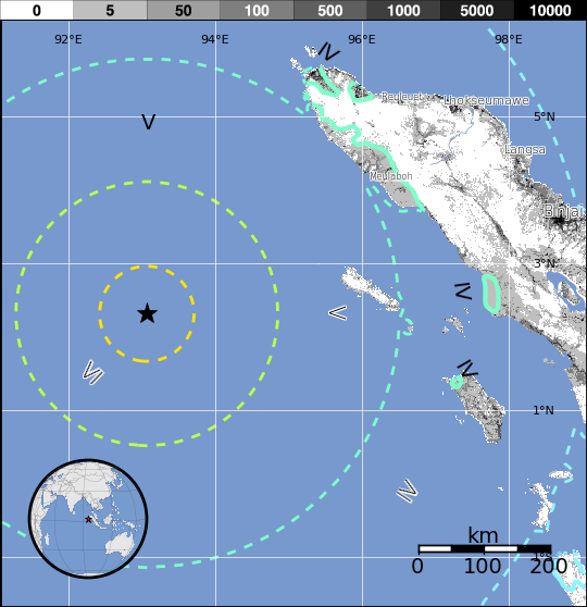
Español: El terremoto del océano Índico de 2012 fue un terremoto de magnitud 8,6 grados en la escala de magnitud de momento que sacudió a Indonesia, Tailandia, Malasia, Sri Lanka, India, Bangladesh, Vietnam, Maldivas y Singapur. Además obligó a emitir una advertencia de tsunami para 20 países debido a la magnitud del sismo y una posterior réplica de 8,2 grados en la escala de magnitud de momento. |
| Date | |
| Source | https://earthquake.usgs.gov/earthquakes/pager/events/us/c000905e/exposure.png |
| Author | USGS |
Licensing
[edit]
This image is in the public domain in the United States because it only contains materials that originally came from the United States Geological Survey, an agency of the United States Department of the Interior. For more information, see the official USGS copyright policy.
|
File history
Click on a date/time to view the file as it appeared at that time.
| Date/Time | Thumbnail | Dimensions | User | Comment | |
|---|---|---|---|---|---|
| current | 17:55, 11 April 2012 | | 540 × 558 (92 KB) | LuchoCR (talk | contribs) |
You cannot overwrite this file.
File usage on Commons
There are no pages that use this file.
File usage on other wikis
The following other wikis use this file:
- Usage on es.wikipedia.org
- Usage on he.wikipedia.org
- Usage on id.wikipedia.org