File:Mappa Linea Maginot.png
Jump to navigation
Jump to search

Size of this preview: 566 × 600 pixels. Other resolutions: 227 × 240 pixels | 453 × 480 pixels | 725 × 768 pixels | 967 × 1,024 pixels | 1,483 × 1,571 pixels.
Original file (1,483 × 1,571 pixels, file size: 479 KB, MIME type: image/png)
Captions
Captions
Add a one-line explanation of what this file represents
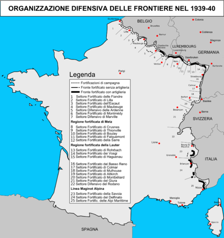
| Description | Mappa rappresentante l'organizzazione difensiva delle frontiere francesi nel 1939-1940 |
| Date | (UTC) |
| Source | |
| Author |
|
| Other versions | File:CarteLigneMaginot.png |
| This is a retouched picture, which means that it has been digitally altered from its original version. Modifications: Traduzione. The original can be viewed here: CarteLigneMaginot.png:
|
I, the copyright holder of this work, hereby publish it under the following license:
This file is licensed under the Creative Commons Attribution-Share Alike 2.0 France license.
- You are free:
- to share – to copy, distribute and transmit the work
- to remix – to adapt the work
- Under the following conditions:
- attribution – You must give appropriate credit, provide a link to the license, and indicate if changes were made. You may do so in any reasonable manner, but not in any way that suggests the licensor endorses you or your use.
- share alike – If you remix, transform, or build upon the material, you must distribute your contributions under the same or compatible license as the original.

Original upload log[edit]
This image is a derivative work of the following images:
- File:CarteLigneMaginot.png licensed with Cc-by-sa-2.0-fr
- 2006-02-18T18:06:51Z Duomaxw 1483x1571 (403359 Bytes) Version sans les fautes.
- 2006-01-31T23:45:21Z Rama 1482x1566 (402817 Bytes) Carte représentant l'organistation défensive de la France en 1939-1940 Auteur : Duomaxw = Sources : = ** Philippe Truttmann, ''La Muraille de France'', Gérard Klopp, [[Thionville]], 1985. ** Jean-Bernard Wahl, ''Il étai
Uploaded with derivativeFX
File history
Click on a date/time to view the file as it appeared at that time.
| Date/Time | Thumbnail | Dimensions | User | Comment | |
|---|---|---|---|---|---|
| current | 20:41, 13 September 2010 | | 1,483 × 1,571 (479 KB) | Gigillo83 (talk | contribs) | {{Information |Description=Mappa rappresentante l'organizzazione difensiva delle frontiere francesi nel 1939-1940 |Source=*File:CarteLigneMaginot.png |Date=2010-09-13 20:36 (UTC) |Author=*File:CarteLigneMaginot.png: Duomaxw *derivative work: |
You cannot overwrite this file.
File usage on Commons
There are no pages that use this file.
File usage on other wikis
The following other wikis use this file:
- Usage on it.wikipedia.org