File:Marcellus shale isobath map 2019 DE.png
Jump to navigation
Jump to search
Size of this preview: 800 × 566 pixels. Other resolutions: 320 × 226 pixels | 640 × 453 pixels | 1,024 × 724 pixels | 1,280 × 905 pixels | 2,560 × 1,810 pixels | 3,507 × 2,480 pixels.
Original file (3,507 × 2,480 pixels, file size: 4.84 MB, MIME type: image/png)
Captions
Captions
Add a one-line explanation of what this file represents
Summary[edit]
| Description |
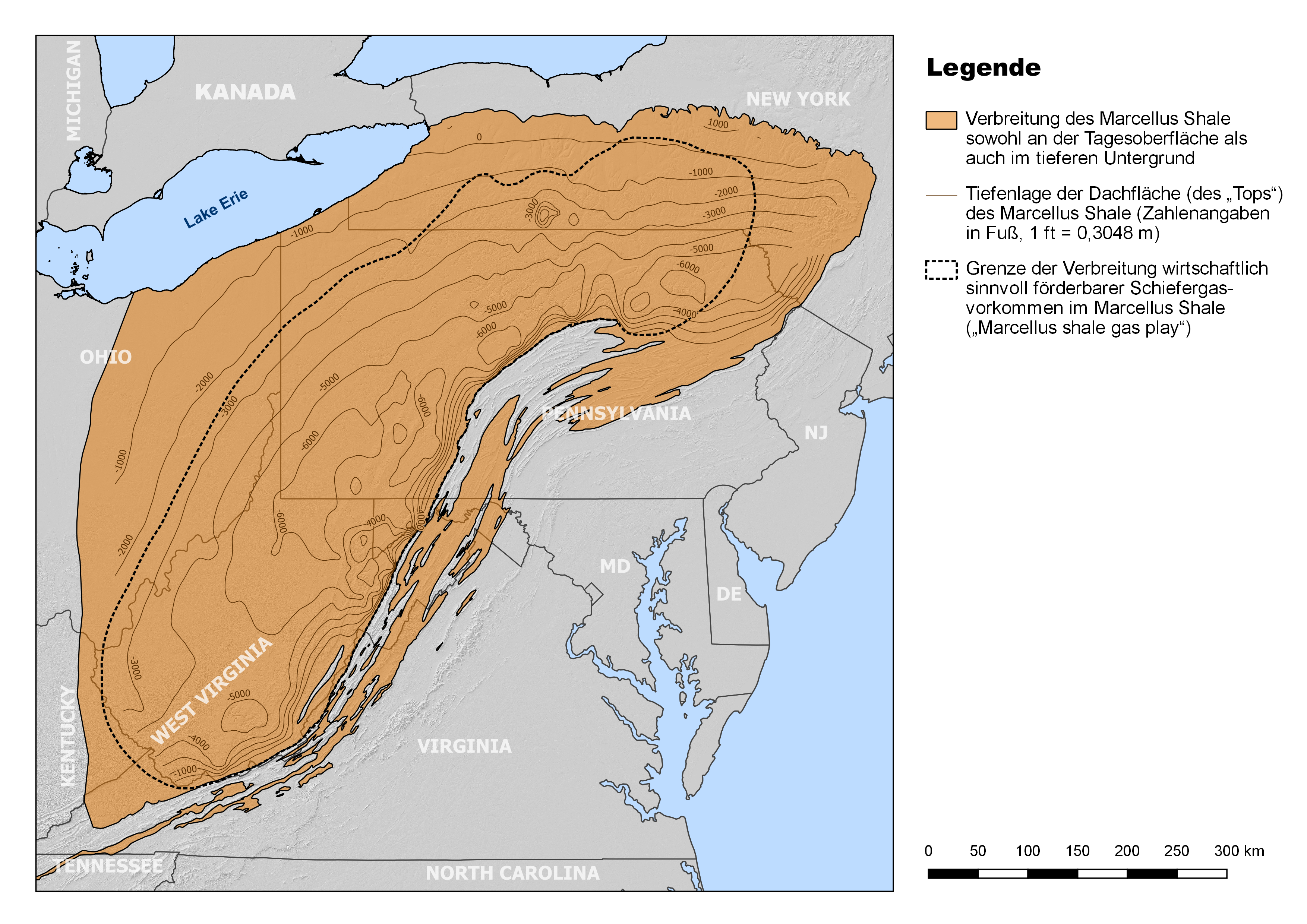
Deutsch: Verbreitung des mitteldevonischen Marcellus Shale im Nordosten der USA (Appalachenbecken) mit Verzeichnung der Tiefenlage der Dachfläche (engl. „Top“) der Formation (Angaben in Fuß bzgl. Meeresspiegelniveau). Wie der Karte zu entnehmen ist, liegt der weit überwiegende Teil der Formation unterhalb der Tagesoberfläche, mit Tiefenmaxima von mehr als 6000 ft (> 1800 m) nahe der Alleghenischen Front. Letztgenannte ist zudem annähernd deckungsgleich mit der östlichen Grenze des „Marcellus shale gas play“.
English: Geographic extent of the Middle Devonian Marcellus Shale in the northeastern U.S. (Appalachian Basin) with indication of the depth of the top surface of the formation (given in feet relative to sea level). As it is obvious from the map, the by far greater portion of the formation lies deep below the surface, reaching maximum depths of more than 6000 ft near the Allegheny Front. The latter is also approximately congruent with the eastern margin of the Marcellus shale gas play. |
| Date | |
| Source |
Own work
|
| Author | Gretarsson |
| Other versions |
 |
Licensing[edit]
I, the copyright holder of this work, hereby publish it under the following license:
This file is licensed under the Creative Commons Attribution-Share Alike 4.0 International license.
- You are free:
- to share – to copy, distribute and transmit the work
- to remix – to adapt the work
- Under the following conditions:
- attribution – You must give appropriate credit, provide a link to the license, and indicate if changes were made. You may do so in any reasonable manner, but not in any way that suggests the licensor endorses you or your use.
- share alike – If you remix, transform, or build upon the material, you must distribute your contributions under the same or compatible license as the original.
File history
Click on a date/time to view the file as it appeared at that time.
| Date/Time | Thumbnail | Dimensions | User | Comment | |
|---|---|---|---|---|---|
| current | 13:50, 22 August 2019 | | 3,507 × 2,480 (4.84 MB) | Gretarsson (talk | contribs) | {{Information |description ={{de|1=Verbreitung des mitteldevonischen Marcellus Shale im Nordosten der USA (Appalachenbecken) mit Verzeichnung der Tiefenlage der Dachfläche (engl. „Top“) der Formation (Angaben in Fuß bzgl. Meeresspiegelniveau). Wie der Karte zu entnehmen ist, liegt der weit überwiegende Teil der Formation unterhalb der Tagesoberfläche, mit Tiefenmaxima nahe der Alleghenischen Front. Letztgenannte ist zudem annähernd deckungsgleich mit der östlichen Grenze des „Marcellus shal... |
You cannot overwrite this file.
File usage on Commons
The following 2 pages use this file:
File usage on other wikis
The following other wikis use this file:
- Usage on de.wikipedia.org