File:Maritime boundaries between Channel Islands and France-fr.svg
Jump to navigation
Jump to search

Size of this PNG preview of this SVG file: 467 × 600 pixels. Other resolutions: 187 × 240 pixels | 374 × 480 pixels | 598 × 768 pixels | 797 × 1,024 pixels | 1,595 × 2,048 pixels | 901 × 1,157 pixels.
Original file (SVG file, nominally 901 × 1,157 pixels, file size: 207 KB)
Captions
Captions
Add a one-line explanation of what this file represents
Summary
[edit]| Description |
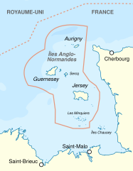
English: Maritime boundaries between Channel Islands and France. Français : Frontières maritimes entre les Îles Anglo-Normande et la France. |
||
| Date | |||
| Source | Maritime boundaries between UK and France in Europe-fr.svg, Sémhur, CC-BY-SA | ||
| Author | Sémhur (talk) | ||
| Other versions | |||
| Attribution (required by the license) | © Sémhur / Wikimedia Commons / | ||
| SVG | W3C-validity not checked.
|
||
| Graphic Lab |

| Object location | | View this and other nearby images on: OpenStreetMap |
|---|
Licensing
[edit]
I, the copyright holder of this work, hereby publish it under the following licenses:
| Copyleft: This work of art is free; you can redistribute it and/or modify it according to terms of the Free Art License. You will find a specimen of this license on the Copyleft Attitude site as well as on other sites. |
This file is licensed under the Creative Commons Attribution-Share Alike 4.0 International, 3.0 Unported, 2.5 Generic, 2.0 Generic and 1.0 Generic license.
- You are free:
- to share – to copy, distribute and transmit the work
- to remix – to adapt the work
- Under the following conditions:
- attribution – You must give appropriate credit, provide a link to the license, and indicate if changes were made. You may do so in any reasonable manner, but not in any way that suggests the licensor endorses you or your use.
- share alike – If you remix, transform, or build upon the material, you must distribute your contributions under the same or compatible license as the original.
You may select the license of your choice.
File history
Click on a date/time to view the file as it appeared at that time.
| Date/Time | Thumbnail | Dimensions | User | Comment | |
|---|---|---|---|---|---|
| current | 19:50, 29 May 2024 | | 901 × 1,157 (207 KB) | Sémhur (talk | contribs) | redresse |
| 19:47, 29 May 2024 |  | 901 × 1,157 (207 KB) | Sémhur (talk | contribs) | ||
| 19:42, 29 May 2024 |  | 300 × 386 (206 KB) | Sémhur (talk | contribs) | == {{int:filedesc}} == {{Information |Description={{Multilingual description |en= Maritime boundaries between Channel Islands and France. |fr= Frontières maritimes entre les Îles Anglo-Normande et la France. }} |Source={{F|File:Maritime boundaries between UK and France in Europe-fr.svg}}, {{User:Sémhur}}, CC-BY-SA }} |Date=2024-05-29 |Author= Sémhur (<span class="signature-talk">talk</span>) |Permission= |other_versions= {{User:Sémhur/Credit}} {{Informatio... |
You cannot overwrite this file.
File usage on Commons
The following page uses this file:
File usage on other wikis
The following other wikis use this file:
- Usage on fr.wikipedia.org
- Wikipédia:Atelier graphique/Cartes
- Discussion:Îles Anglo-Normandes
- Wikipédia:Statistiques des anecdotes de la page d'accueil
- Wikipédia:Statistiques des anecdotes de la page d'accueil/Visibilité des anecdotes (2024)
- Wikipédia:Le saviez-vous ?/Archives
- Discussion:Îles Anglo-Normandes/LSV 23203
- Wikipédia:Statistiques des anecdotes de la page d'accueil/Visibilité des anecdotes (2024)/2024 08
- Wikipédia:Réseaux sociaux/X/Publications/archives/août 2024