File:Martian north polar cap.jpg
跳转到导航
跳转到搜索

本预览的尺寸:622 × 600像素。 其他分辨率:249 × 240像素 | 498 × 480像素 | 797 × 768像素 | 1,062 × 1,024像素 | 1,368 × 1,319像素。
原始文件 (1,368 × 1,319像素,文件大小:1 MB,MIME类型:image/jpeg)
说明
说明
添加一行文字以描述该文件所表现的内容
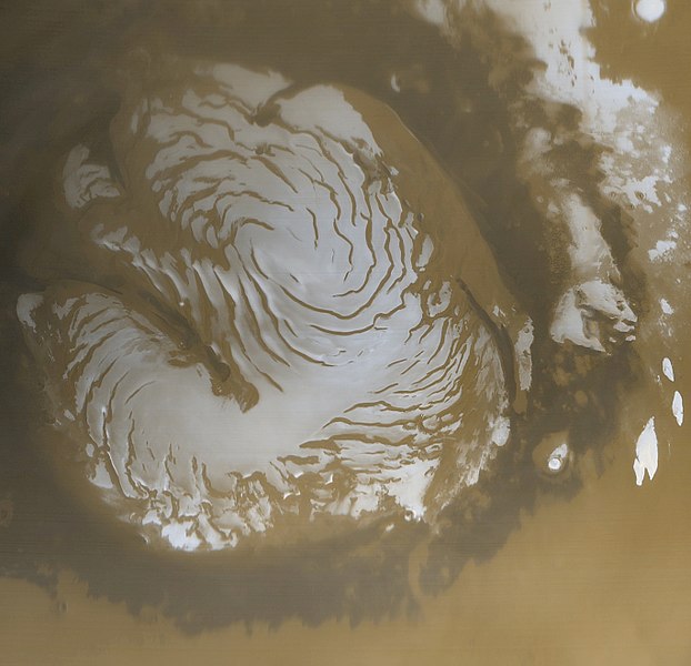
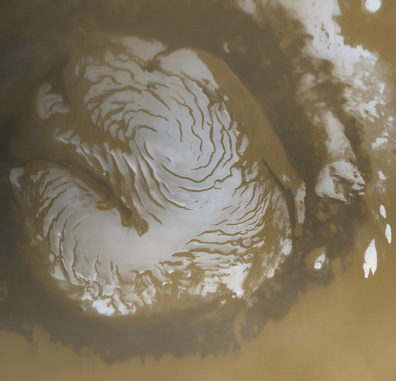
火星北极初夏的冰盖(1999年)
摘要[编辑]
| 描述 |
English: The Mars Global Surveyor (MGS) Mars Orbiter Camera (MOC) acquired this image of the Martian north polar cap in early northern summer. The picture was acquired on March 13, 1999, near the start of the Mapping Phase of the MGS mission. The light-toned surfaces are residual water ice that remains through the summer season. The nearly circular band of dark material surrounding the cap consists mainly of sand dunes formed and shaped by wind. The north polar cap is roughly 1100 kilometers (680 miles) across.
Ελληνικά: Ο Βόρειος Πόλος του πλανήτη Άρη, φωτογραφημένος από τη διαστημοσυσκευή Mars Global Surveyor το 1999. Όταν λήφθηκε η φωτογραφία στο βόρειο ημισφαίριο του πλανήτη ήταν καλοκαίρι, και έτσι ο πάγος που παρατηρείται είναι πάγος νερού, που βρίσκεται κάτω από ένα στρώμα πάγου διοξείδιου του άνθρακα, που το καλοκαίρι εξατμίζεται. Η σκοτεινή περιοχή γύρω από τον πάγο είναι μια "θάλασσα" από άμμο που περιβάλλει τον Βόρειο Πόλο.
|
|||||
| 日期 | The picture was acquired on March 13, 1999 | |||||
| 来源 | ||||||
| 作者 | NASA/JPL/Malin Space Science Systems | |||||
| 授权 (二次使用本文件) |
|

| 此标签不表示文件的著作权状态。任何文件在附有此标签的同時还需要一个有效的著作权标签。请参阅许可协议说明页面以了解更多信息。 其他语言:
|
文件历史
点击某个日期/时间查看对应时刻的文件。
| 日期/时间 | 缩略图 | 大小 | 用户 | 备注 | |
|---|---|---|---|---|---|
| 当前 | 2011年9月18日 (日) 13:30 | | 1,368 × 1,319(1 MB) | Badseed(留言 | 贡献) | uploading full resolution |
| 2008年8月3日 (日) 21:53 |  | 419 × 404(134 KB) | BatteryIncluded(留言 | 贡献) | {{Information |Description=The Mars Global Surveyor (MGS) Mars Orbiter Camera (MOC) acquired this image of the Martian north polar cap in early northern summer of. The picture was acquired on March 13, 1999, near the start of the Mapping Phase of the MGS |
您不可以覆盖此文件。
文件用途
没有页面使用本文件。
全域文件用途
以下其他wiki使用此文件:
- ar.wikipedia.org上的用途
- az.wikipedia.org上的用途
- be.wikipedia.org上的用途
- ca.wikipedia.org上的用途
- de.wikipedia.org上的用途
- el.wikipedia.org上的用途
- en.wikipedia.org上的用途
- en.wikibooks.org上的用途
- en.wikiversity.org上的用途
- es.wikipedia.org上的用途
- eu.wikipedia.org上的用途
- fa.wikipedia.org上的用途
- fr.wikipedia.org上的用途
- he.wikipedia.org上的用途
- hi.wikipedia.org上的用途
- hr.wikipedia.org上的用途
- hy.wikipedia.org上的用途
- id.wikipedia.org上的用途
- incubator.wikimedia.org上的用途
- ja.wikipedia.org上的用途
- kv.wikipedia.org上的用途
- lb.wikipedia.org上的用途
- mnw.wikipedia.org上的用途
- pnb.wikipedia.org上的用途
- pt.wikipedia.org上的用途
- pt.wikibooks.org上的用途
- ru.wikipedia.org上的用途
- sc.wikipedia.org上的用途
查看本文件的更多全域用途。